
Dodger Stadium Transportation Study
LADOT Dodger Stadium Bicycle and Pedestrian Map
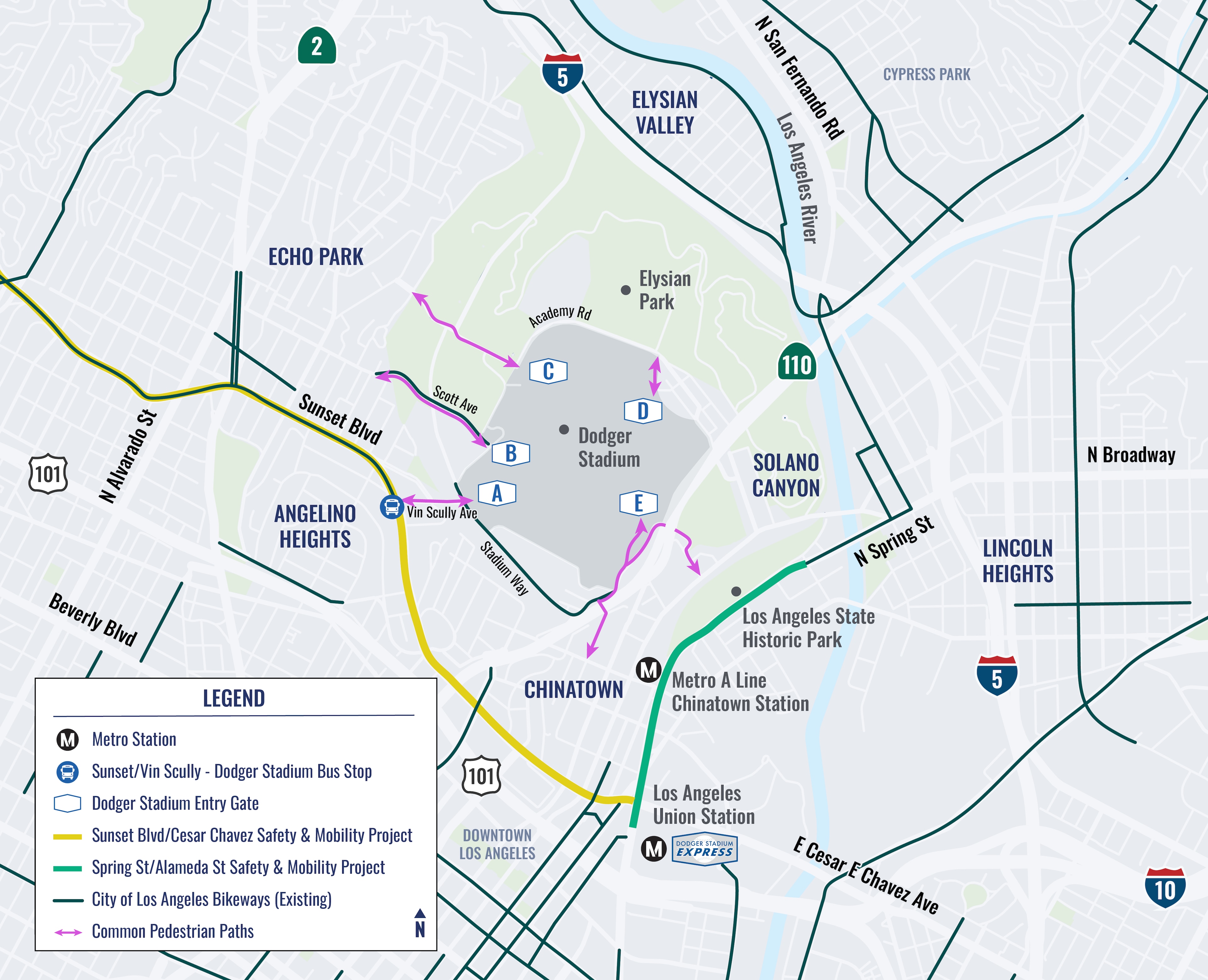
The City of Los Angeles is conducting a transportation study to identify potential strategies to improve access to and from Dodger Stadium and reduce impacts on neighboring communities. The study will assess event-day and non-event day conditions across all travel modes and the impacts on surrounding neighborhoods, including Solano Canyon, Elysian Valley, Echo Park, Chinatown, Angelino Heights, and Lincoln Heights. The study will issue short- and long-term recommendations based on community input and current multimodal traffic patterns involving vehicle, shuttle, transit, bike, and pedestrian travel.
Dodger Stadium hosts a number of baseball games and events every year with tens of thousands of attendees at a time. Currently, most attendees drive, contributing to traffic congestion and access issues in nearby neighborhoods. The purpose of this study is to look at current conditions for all modes of transportation and issue recommendations to help improve access for attendees and mitigate impacts for the surrounding community.
The City of Los Angeles is also planning safety and mobility upgrades for pedestrians, cyclists, and transit riders along Sunset Boulevard and Cesar Chavez Avenue. Together, these interconnected efforts will help create a safer and more cohesive transportation network for people traveling by walking, biking, transit, and driving. Click here to learn more about the Sunset Blvd/Cesar Chavez Safety & Mobility Project.
A public survey and engagement activities are being conducted to generate community feedback and gain a better understanding of the safety and accessibility concerns for getting to and from Dodger Stadium, while also considering how to lessen the effects on nearby neighborhoods. With your meaningful feedback, solutions will be identified to benefit local communities and improve the range of options for accessing Dodger Stadium. Complete the Dodger Stadium Transportation Study survey by Friday, July 31, 2026, for a chance to win a $50 gift card!
Earlier this year, the project team engaged with community members to share about the study, existing conditions, and collect feedback at local events. In partnership with community-based organizations, the project team engaged with more than 700 people at community events within the study area and nearly 6,000 homes and businesses through canvassing.
May 2026 – Walk and Bike Audits (x4)
Key travel routes to and from Dodger Stadium
May-June 2026 - Transit Intercept Surveys
May 14 – Dodger Stadium Express at LA Union Station
May 14 – Sunset Blvd/Vin Scully Ave bus stop
May 29 – Chinatown Metro Station
June 5 – Echo Park Ave/Scott Ave bus stop
June-July 2026 – Pop-Up Events
June 12 – LA State Historic Park
June 26 – Kick It in the Park – Echo Park Lake
July 10 – CD-1 Park-to-Park Open Streets Community Event
July 11 – LA Lotus Festival – Echo Park Lake
July 2026 – Community Open House
July 11 – Community Open House at LA Lotus Festival – Echo Park Lake
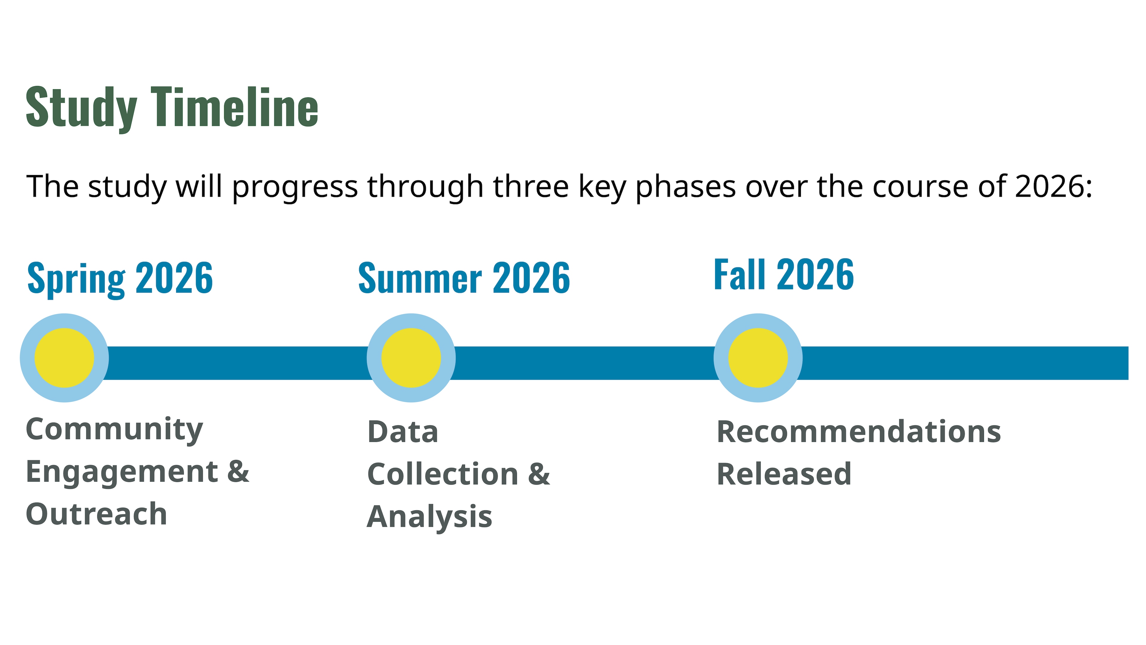
Public engagement activities are set to began in Spring 2026. To stay informed about the project and learn how you can get involved, be sure to sign up for updates to be informed of confirmed activities as well as other updates on the Dodger Stadium Transportation Study.
The project team can be reached by emailing us.