LADOT develops transportation plans and programs that advance sustainable mobility in the City of Los Angeles. LADOT actively plans mobility investments and reviews development projects to determine the best outcomes for the City of LA. Additionally, LADOT contributes to state, regional, and local transportation planning efforts, led by Caltrans, SCAG, and Metro, to address mobility investments, transit station connectivity, goods movement, high-speed rail, sustainability, congestion management, and regional and citywide equity. LADOT also reviews environmental documents for land use and transportation infrastructure projects.
Projects:
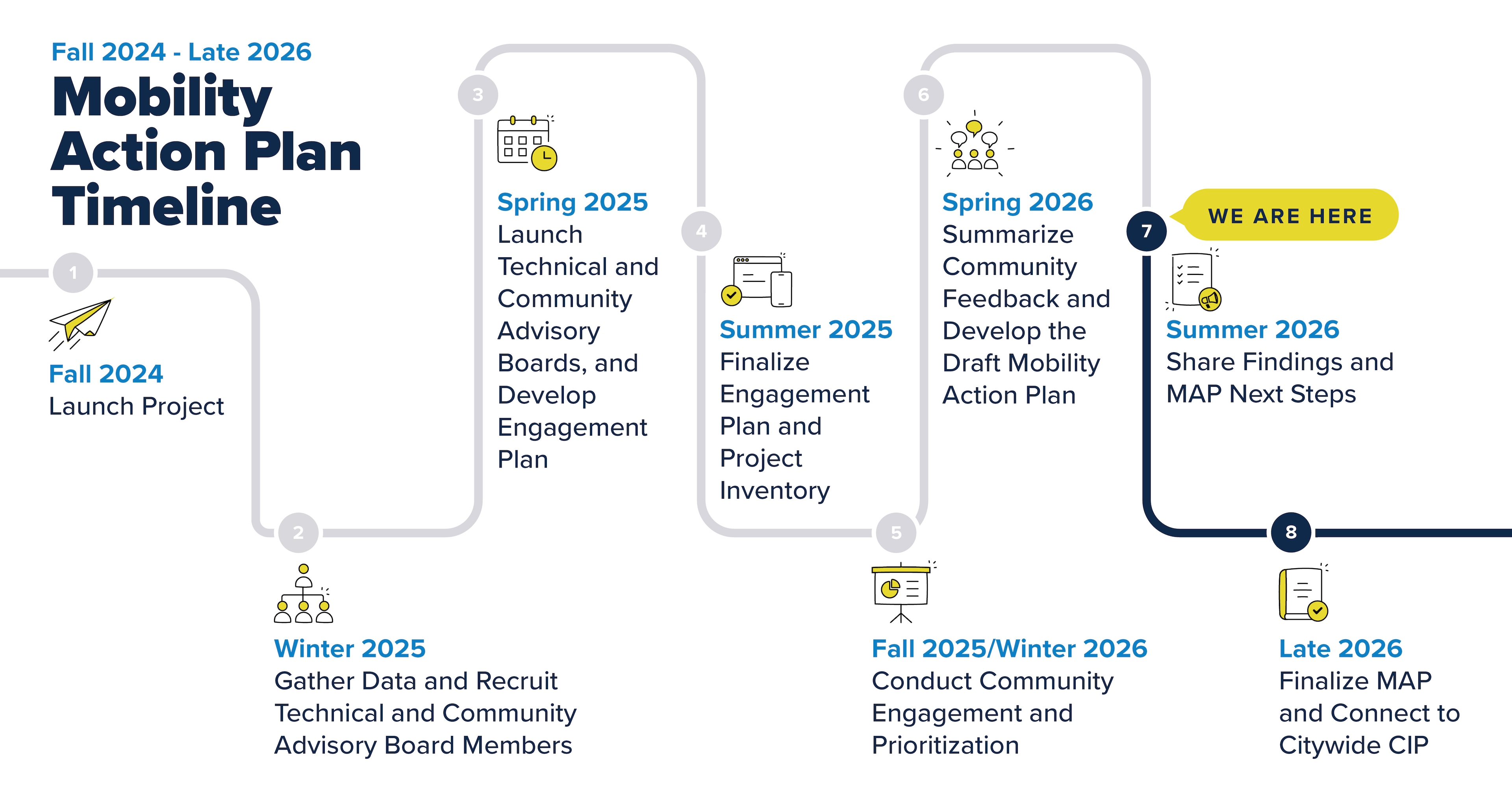
In The Los Angeles Department of Transportation (LADOT), along with a Community Advisory Board and Technical Advisory Committee, is leading the City’s first Mobility Action Plan (MAP) to guide future transportation investments with a focus on safety, equity, access, and sustainability. The MAP will create a list of prioritized transportation investments for Los Angeles that advance our City’s policy goals and community vision.
Learn more and follow the process on the Mobility Action Plan website.
To receive updates about the project, please sign up for our email newsletter.
Downtown Los Angeles Mobility Investment Plan
The Downtown Los Angeles Mobility Investment Program (DTLA MIP) prepares the City to meet the transportation needs of current and future residents, workers, and visitors. Downtown Los Angeles (DTLA) is the regional hub of business, culture, and transportation with a residential population that is expected to more than double by 2040. The DTLA MIP prioritized inclusive, equitable, sustainable, and healthy growth for DTLA, with a goal of addressing mobility and access gaps.
The DTLA MIP is a comprehensive list of projects and programs developed through a community first engagement process that asked residents and workers of Downtown Los Angeles about their specific mobility barriers and needs. The DTLA MIP built upon previous planning and community engagement efforts, such as the DTLA 2040 Community Plan, to prioritize inclusive, equitable, sustainable and healthy growth for DTLA. Through this process, the DTLA MIP created a roadmap for the City of Los Angeles to invest in transportation infrastructure and programs that support a safe and reliable travel experience for all in DTLA. LADOT implements DTLA MIP identified priority projects as funding opportunities become available. LADOT will periodically update the DTLA MIP Project List as projects are completed.
View past DTLA MIP materials and the final report using the links below:
● Project Factsheet (English, Spanish, Vietnamese, Japanese, Korean, Chinese)
● DTLA MIP Introduction Overview Video
● DTLA MIP Final Report (coming soon)
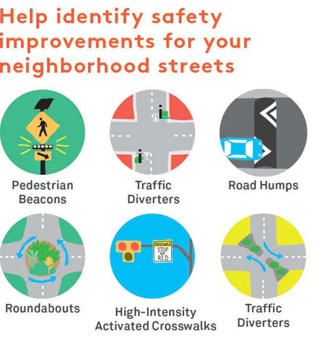
Stress Free Connections projects create a comfortable network of connected residential streets with easier crossings for localized travel by people of all ages and abilities. Through this effort, LADOT collaborated with communities to address barriers to mobility and advance new street design concepts to improve the comfort and safety of people who walk, bike, or roll on neighborhood streets. This effort was funded through a Caltrans Planning Grant and focused on planning Stress Free Connections in four focus neighborhoods from 2019-2022.
Learn More About Previous Efforts on this Project:
- Council File 17-1196
- Planning for Stress-Free Networks Factsheet
- Central LA | South LA | Watts | Mid-City
- Map of estimated Level of Travel Stress for the Mobility Plan’s neighborhood bikeway corridors
- Bicycle Latent Demand Neighborhood Identification Report: Outlines the process for identifying areas within the Central City subregion that have greater potential to promote active transportation
- Focus Geographies and Networks: Maps of neighborhood networks within Central City that LADOT focused on based on analysis of latent demand and level of travel stress
- Stress Free Connections Implementation Guide: Document that provides tools for successful implementation of low-stress neighborhood bikeways
- Level of Traffic Stress (LTS) Standard Operating Procedure Report: Explains methodology for calculating stress levels for streets and intersections
- Vehicle Miles Traveled, Demand, and Equity Analysis: Quantifies additional benefits of building out neighborhood bikeways.
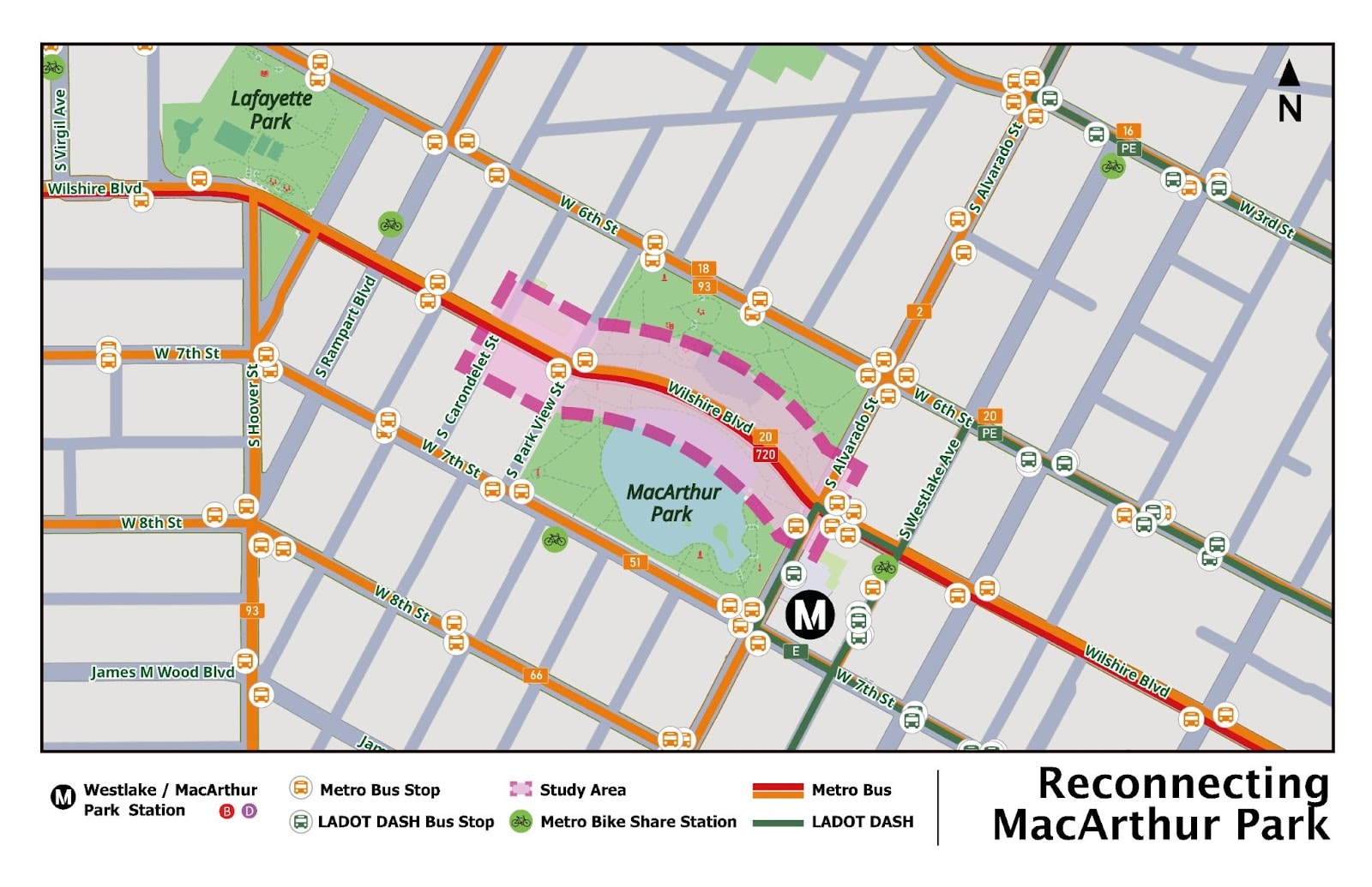
The Reconnecting MacArthur Park study will explore the potential permanent closure of Wilshire Boulevard to vehicle travel between Carondelet Street and Alvarado Street in the City of Los Angeles. The study includes transportation analysis, community visioning, community engagement, and conceptual planning. The study will examine how a multimodal “open streets” concept for this transit-dense neighborhood could better connect residents with housing, jobs, schools, and park space. Reconnecting MacArthur Park studies ways to correct the historic environmental injustice that split the park in two, reducing green space, and separating the neighborhood.
MacArthur Park (formerly known as Westlake Park) was bifurcated in 1934, extending Wilshire Boulevard, in order to prioritize the movement of automobiles. As a result, the northern portion of the lake was drained and parkgoers could only access the opposite side of the park via two pedestrian tunnels built under Wilshire Boulevard. Due to similar land use planning decisions of the past, the surrounding neighborhoods of Westlake and Pico Union are considered “park-poor” since they contain only 0.5 acres of open space, compared to the City average of 8.9 acres per 1,000 residents. The Reconnecting MacArthur Park study envisions increasing much-needed green space in this community. While defined as “park poor”, this neighborhood is also very “transit-rich”, with several high frequency bus lines serving the park including Metro Lines 20, 51 and 720, as well as DASH E, DASH Pico Union/Echo Park, and Metro’s B/D Line Westlake/MacArthur Park rail station within close proximity. As a result of the many transit options, high density of housing and retail, and low availability of vehicle parking spaces, this community has some of Los Angeles County’s highest transit ridership and lowest car ownership rates. These factors further exacerbate the need for accessible green, open space.
The Reconnecting MacArthur Park team is currently conducting community engagement through surveys, a monthly Community Advisory Council (CAC), workshops, and focus groups. Community engagement will inform conceptual design of the project through February 2026. This first phase of the project is funded through a SCAG Sustainable Communities Program Civic Engagement, Equity & Environmental Justice (SCP CEEEJ) grant and is suppointed by a consultant team in partnership with Central City Neighborhood Partners. LADOT is supporting this work in collaboration with Council District 1.
The second phase of this project includes preparing an environmental assessment, developing design and engineering plans for the reconnected park, and developing a preliminary design for the closure of Wilshire Blvd from Park View St and Carondelet St. The second phase is expected to be completed by 2028 and will be led by the Bureau of Engineering, in partnership with the Department of Recreation and Parks, Council District 1, and Central City Neighborhood Partners.