
LADOT develops transportation plans and programs that advance sustainable mobility in the City of Los Angeles. LADOT actively plans mobility investments and reviews development projects to determine the best outcomes for the City of LA. Additionally, LADOT contributes to state, regional, and local transportation planning efforts, led by Caltrans, SCAG, and Metro, to address mobility investments, transit station connectivity, goods movement, high-speed rail, sustainability, congestion management, and regional and citywide equity. LADOT also reviews environmental documents for land use and transportation infrastructure projects.
Projects:
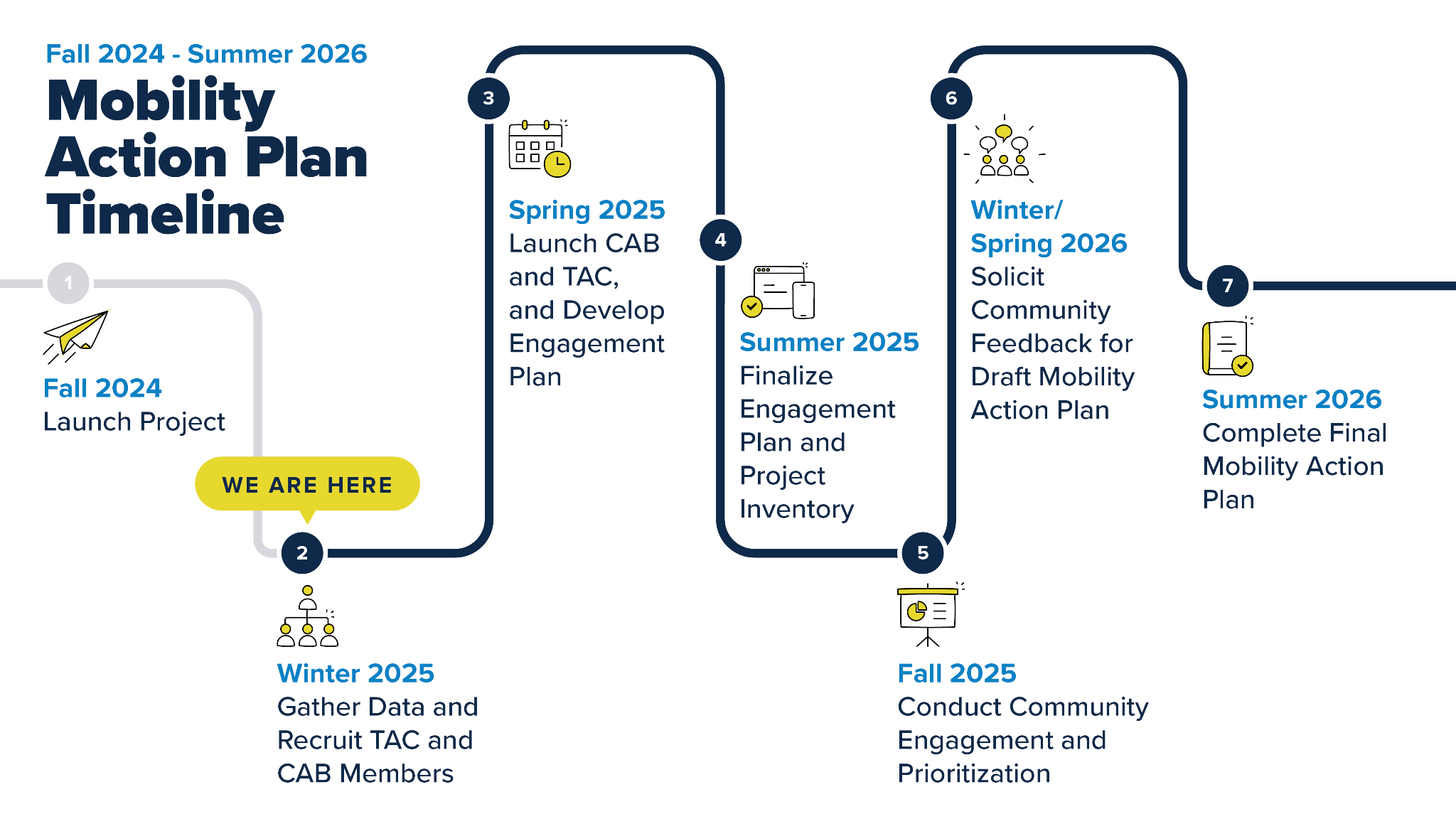
In Fall 2024, the Los Angeles Department of Transportation (LADOT) kicked off the City’s first-ever Mobility Action Plan (MAP). The MAP will create a list of prioritized transportation investments for Los Angeles that advance our City’s policy goals and community vision. These transportation investments will be organized into a five-year Transportation Capital Improvement Plan (2028–2032) and a 20-year transportation investment strategy (2033–2052), as a guide for how the City makes transportation funding and delivery decisions.
What is the purpose of the Mobility Action Plan?
The MAP will guide how Los Angeles invests in transportation projects, programs, and services. The MAP will ensure the City continues to focus on the City’s Mobility Plan 2035 policy goals of improving safety, access, sustainability, and equity. It will also support the implementation of the transportation networks in the City’s Mobility Plan 2035, creating connected infrastructure for people of all ages. The MAP is also part of the City’s response to Mayor Karen Bass’ Executive Directive 9, guiding transportation investments within the larger citywide Capital Investment Plan.
Who will be involved in the Mobility Action Plan process?
The MAP will be shaped by input from a Community Advisory Board (CAB), a Technical Advisory Committee (TAC) of City staff with diverse expertise, and citywide community feedback. Citywide outreach efforts will focus on historically underserved communities to ensure the MAP reflects the transportation needs of all Angelenos. CAB recruitment concluded in March 2025.
What type of projects will be included in the Mobility Action Plan?
The MAP will include transportation projects, programs, and services that improve how people move around Los Angeles. This includes complete streets projects, safety and connectivity treatments, and dedicated bus lane projects to make streets safer and more connected for everyone. It is anticipated that there will be more demand for transportation projects than available funding and staffing resources to implement them. Staff will prioritize the highest need projects guided by principles of equity, safety, access, and connectivity.
How will projects in the Mobility Action Plan be funded?
The MAP is a guide for how City staff and decision-makers make transportation funding and delivery decisions. As part of the MAP process, LADOT will identify budgetary needs and funding sources for projects included in the five-year Transportation Capital Improvement Plan, which will cover fiscal years 2028 to 2032. To implement priority projects, programs, and services in the MAP, the City will need to align available local funds and staff resources to the plan and then pursue state and federal grants. Staff will also consider innovative funding strategies for project delivery and maintenance.
How will the Mobility Action Plan incorporate equity?
The MAP aims to provide access to safe and affordable transportation options, especially in neighborhoods that have been historically underserved. Guided by LADOT’s Universal Basic Mobility (UBM) commitment, the MAP will identify areas of the City with the greatest transportation need using a tailored version of the Los Angeles Community Health and Equity (CHE) Index. Input from the Community Advisory Board and feedback from residents will ensure that the MAP’s goals and investments reflect the priorities of underserved communities.
How can I get involved in the Mobility Action Plan process?
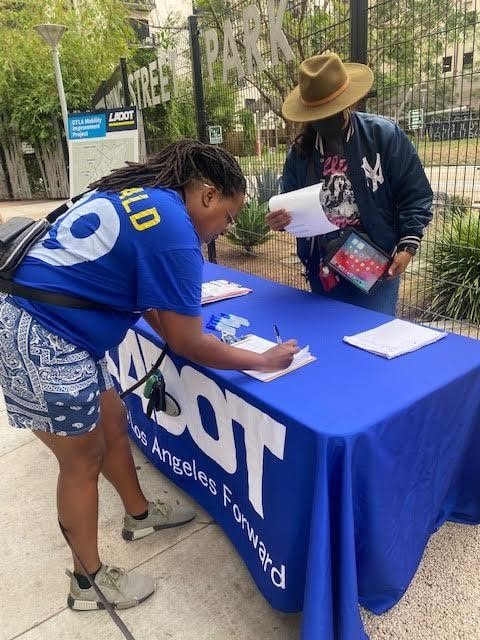
There are many ways to get involved in the MAP. LADOT will hold events across the city to gather ideas and make sure the MAP reflects community needs, especially in historically underserved neighborhoods. Information about future MAP engagement events will be shared via this webpage and LADOT social media accounts. You can also share your input or suggestions by emailing the MAP team at LADOT.MAP@lacity.org. To receive updates about the project, please sign up for our email newsletter here.
Downtown Los Angeles Mobility Investment Plan
The DTLA MIP is a comprehensive list of projects and programs developed through a community first engagement process that asked residents and workers of Downtown Los Angeles about their specific mobility barriers and needs. DTLA is the regional hub of business, culture, and transportation with a residential population that is expected to more than double by 2040. The DTLA MIP prepares the City to meet the transportation needs of current and future residents, workers, and visitors. The DTLA MIP prioritized inclusive, equitable, sustainable, and healthy growth for DTLA, with a goal of addressing mobility and access gaps.
The Downtown Los Angeles Mobility Investment Program (DTLA MIP) built upon previous planning and community engagement efforts, such as the DTLA 2040 Community Plan, to prioritize inclusive, equitable, sustainable and healthy growth for DTLA. Through this process, the DTLA MIP created a roadmap for the City of Los Angeles to invest in transportation infrastructure and programs that support a safe and reliable travel experience for all in DTLA.
Learn More About Previous Efforts on this Project:
● Project Factsheet
● DTLA MIP Introduction Overview Video
● DTLA MIP Feedback Tool
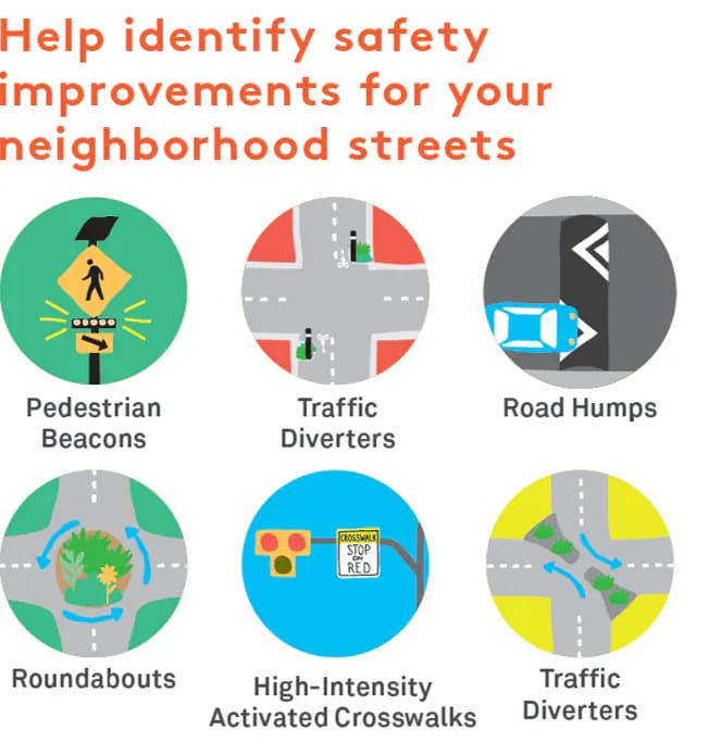
Stress Free Connections projects create a comfortable network of connected residential streets with easier crossings for localized travel by people of all ages and abilities. Through this effort, LADOT collaborated with communities to address barriers to mobility and advance new street design concepts to improve the comfort and safety of people who walk, bike, or roll on neighborhood streets. This effort was funded through a Caltrans Planning Grant and focused on planning Stress Free Connections in four focus neighborhoods from 2019-2022.
Learn More About Previous Efforts on this Project:
- Council File 17-1196
- Planning for Stress-Free Networks Factsheet
- Central LA | South LA | Watts | Mid-City
- Map of estimated Level of Travel Stress for the Mobility Plan’s neighborhood bikeway corridors
- Bicycle Latent Demand Neighborhood Identification Report: Outlines the process for identifying areas within the Central City subregion that have greater potential to promote active transportation
- Focus Geographies and Networks: Maps of neighborhood networks within Central City that LADOT focused on based on analysis of latent demand and level of travel stress
- Stress Free Connections Implementation Guide: Document that provides tools for successful implementation of low-stress neighborhood bikeways
- Level of Traffic Stress (LTS) Standard Operating Procedure Report: Explains methodology for calculating stress levels for streets and intersections
- Vehicle Miles Traveled, Demand, and Equity Analysis: Quantifies additional benefits of building out neighborhood bikeways.