PURPOSE
In 2019, the Los Angeles Department of Transportation (LADOT) commissioned Changing Lanes, a study to advance its efforts to achieve a gender-equitable transportation system. One of the main obstacles to this goal is the lack of data pertaining to the unique experiences and needs of women navigating Los Angeles’ transportation system. Changing Lanes addresses that shortcoming.
A landmark step toward rectifying this gendered data imbalance, Changing Lanes employs a variety of methods—analyzing existing studies, collecting survey data, conducting interviews on travel patterns, convening local community stakeholder groups—to add empirical evidence to the growing body of research at the intersection of gender and mobility.
FINDINGS
The research team focused its analysis on three Los Angeles neighborhoods—Sun Valley in the Valley region, Watts in the Central City region, and Sawtelle in the Westside region—chosen, in part, due to their high proportions of BIPOC residents and women workers living in zero-car households. All data collection across the three study neighborhoods was inspired by Community-Based Research (CBR), a participatory approach that pairs researchers with community members throughout all phases of the process. Across all neighborhoods, the project team identified a consistent pattern: the Los Angeles transportation system is failing women.
For BIPOC women, this failure is even more pronounced. In addition to gender inequities, BIPOC women face racial barriers to safe and accessible transportation, maneuvering factors like historic under investment, racist housing and zoning practices, and economic disenfranchisement.
Changing Lanes also reveals the critical role of income in determining women’s experiences of gender inequity. While higher-income women can often leverage their resources to overcome gendered travel challenges, lower-income women are left dependent on systems that do not account for their needs.
ADDITIONAL FINDINGS
Barriers to travel
- A smaller percentage of women have driver’s licenses than do men.
- Respondents in Watts and Sun Valley are more likely to report perceptions of danger at night, fear of crime, and poor sidewalk conditions as barriers to walking than are respondents in Sawtelle.
- Sun Valley residents are more likely than Sawtelle residents to report a lack of destinations nearby
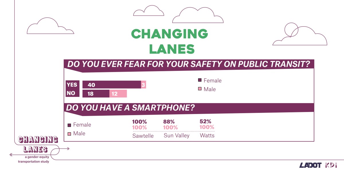
- Men have higher access to smartphones and computers than do women.
Recreation
- Women are more likely than are men to report transportation as a barrier to recreation trips.
- Recreation trips, for both men and women, are the most common types of trips avoided due to transportation difficulties.
Safety
- Women are more likely than men to be concerned about their safety while using public transit.
- Respondents that identify as Latinx, Black, or Asian, are more likely than those that identify as White or other to feel unsafe.
Travel patterns
- Women are more likely than men to use multiple transportation modes in a day
- Women are more likely than men to trip-chain, or make multiple stops during a single trip, during trips that do not include commutes.
- Men, before and during the pandemic, are more likely than women to use active transportation modes, which include bicycles, skateboards, and scooters.
Travel and employment changes during COVID-19 pandemic
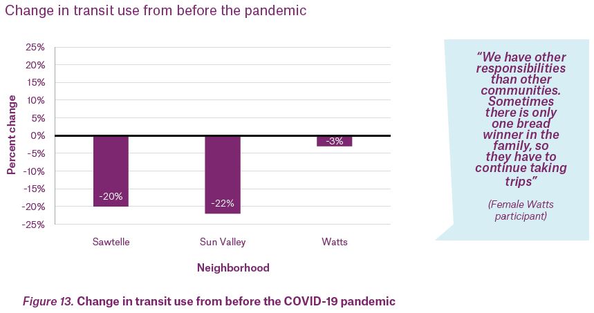
- Transit use declined in all three neighborhoods compared to before the COVID-19 pandemic, with the smallest decline in Watts.
- Across the three neighborhoods, Watts respondents suffered the greatest job loss as a result of the COVID-19 pandemic.
- Employment losses were greater for women than for men.
Destination access
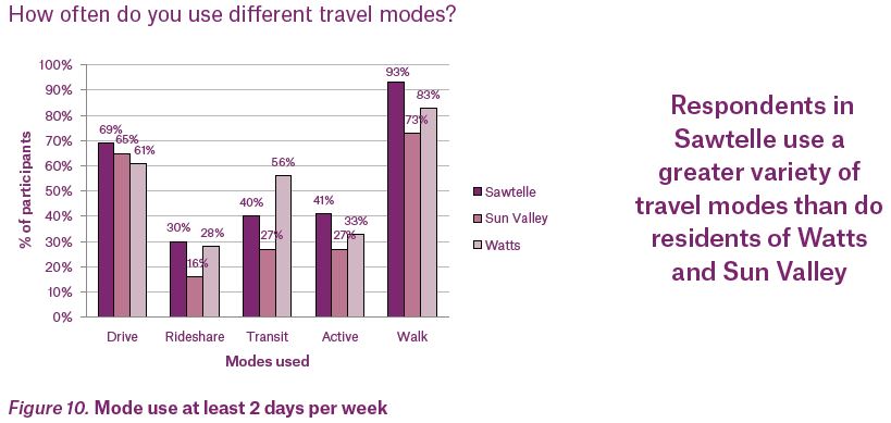
- Respondents in Sawtelle, which has a greater mix of destination types than the other two neighborhoods, used a greater variety of travel modes and are more likely to use active modes than respondents in Watts and Sun Valley.
- Sawtelle respondents were more likely to find all their daily destinations within their neighborhood than were residents of Watts and Sun Valley. In both Watts and Sun Valley, women were less likely than men to be able to access their daily destinations within their neighborhood.
- In all three neighborhoods, women are more likely than men to have long duration grocery store trips (over 45 minutes)
RECOMMENDATIONS
LADOT commissioned Changing Lanes with the explicit objective of prioritizing equity in transportation planning and design. The only viable means of achieving this goal is to focus on directly serving low-income, BIPOC women and communities at every stage of the planning and implementation process—from resource allocation and design to project execution and administrative support. Changing Lanes understands equitable planning not as a supplement to existing processes, but rather as a holistic, systematic effort towards rectifying historic and current injustices. The study’s recommendations and implementation strategies were crafted accordingly.
The Implementation Strategies section is presented in four categories, each of which is accompanied by a series of relevant, actionable steps to create a gender-equitable transportation system.
A. Closing the Data Gap outlines ways to make better decisions with data. Strategies of note include:
- Adapt current data collection efforts and establish new data collection efforts to ensure the inclusion of gender or perceived gender, race/ethnicity, and other intersectional categories like income, ability, and age.
- Engage Community Based Organizations (CBOs) involved in gender-, race- , sexuality-, age-, and disability-based advocacy to identify key issues and specific concerns related to mobility.
B. Inclusive Infrastructure describes how the built environment should inform transportation decisions and how it can be improved to increase women’s mobility. Strategies of note include:
- In low- and medium-density neighborhoods, where destinations and opportunities are further away, focus strategies on expanding access to transportation modes better suited to long distance travel like automobiles and public transit, understanding that the ability of public transit to meet women’s complex travel needs may remain limited in these areas.
- In high-density, mixed-use neighborhoods with multiple destinations located within ¼-½ mile, focus strategies on increasing walking, bicycling, and other active modes.
- Since automobiles accommodate trip-chaining better than other modes, partner with other agencies and CBOs to improve women’s access to driver’s licenses and vehicles that accommodate long trips.
- In low- and medium-density neighborhoods, partner with the Department of City Planning and other agencies that inform land use development to encourage the
15-minute city
concept, promoting the location of destinations women most often travel to such as healthy grocery stores, libraries, clinics, recreation opportunities, childcare facilities, and essential services in close proximity to housing.
C. Services offer guidance on how to improve existing services and add new options that better meet the needs of women. Strategies of note include:
- Design a weekend, point-to-point transit service—informed first and foremost by the needs of women caregivers in low-income neighborhoods—that connects them to recreation and open-space opportunities, especially to and from beaches.
- Partner with CBOs, housing authorities, and affordable housing developments to pilot non-profit van- and car-sharing models in low-income, BIPOC communities.
D. Programs offer ideas for how public initiatives can work alongside infrastructure and mode options to increase women’s mobility, particularly low-income BIPOC women. Strategies of note include:
- Introduce residents in low-income BIPOC communities to new mobility services, like BlueLA, and guide them on best practices for usage through culturally competent outreach, engagement, education, demonstration, and evaluation.
- Hire local women as community ambassadors to provide a visible, culturally-competent safety presence in public spaces like street corners, parks, and crosswalks, and offer general assistance to transit users, particularly in low-income BIPOC communities where increased police presence may not necessarily lead to increased levels of safety.
Properly applied, these implementation strategies have the potential to establish Los Angeles as a national leader in equitable, efficient, and affordable transportation solutions for all genders.
A NOTE ON ACCESS TO AUTOMOBILES
Changing Lanes envisions a transition away from automobile dependency, towards a Los Angeles in which public and active transportation options are practical and equally accessible across income levels. It also understands that this is a long-term goal—one that we are decades from achieving.
Research demonstrates the vital role cars currently play in the lives of low-income women and their families. Cars offer reliability, route flexibility, storage capacity, autonomy, and the ability to travel long distances. In communities lacking reliable public transportation, cars are an essential means of accessing economic opportunities and critical destinations like schools, health clinics, day cares, and grocery stores. While reducing personal car use is an important objective with significant environmental benefits, it is not without potential pitfalls. If carried out hastily,
such a transition risks inadvertently harming vulnerable communities.
LADOT must take a measured approach to the question of automobile access, balancing the immediate needs of low-income women and their families with aspirations for universal, equitable public transportation. To this end, we offer a number of recommendations tailored to ensuring a just transition to car independence, such as investing in car- and van-share programs and evaluating interest in neighborhood-based dial-a-ride services. A just transition also requires, in part, recognizing that travel by high-income households accounts for the majority of the negative environmental externalities of driving. Equitable approaches to increasing car access should improve access to driving among those who most stand to benefit, while managing the driving of the heaviest polluters.

Transportation is not just a matter of networks and infrastructure. It is, more accurately, a critical means of self-determination, since access to mobility has substantive impact on a range of other outcomes, including education, employment, health services, civic participation, recreational opportunities, and housing options. Inequitable access to transportation, therefore, has profound consequences, negatively affecting quality of life across many metrics, and, by extension, compromising the overall economic health of the city.
In cities around the world, women have long been overlooked in transportation planning. This is true of Los Angeles, where transportation systems have been shaped over generations primarily by and for men. City planners have tended to use the commutes of cisgender, able-bodied men as the prototype: a point-A-to-point-B commute between residential areas and commercial centers during peak hours. In structuring systems to meet that need, they have largely failed to incorporate the unique interests and experiences of women into the design process. Thus, despite accounting for the majority of transit ridership and household travel in Los Angeles, women must navigate a system that is often unresponsive to their needs, and, in many cases, carries the specter of threat or danger.
In the face of this disparity, the City has an historic opportunity to reshape its transportation system, ensuring that its many facets—from roads and cycling infrastructure to bus benches and sidewalks—equitably serve all Angelenos, regardless of gender. Unprecedented investments in infrastructure and public transit, coupled with emerging autonomous and shared modes of travel, have the potential to catalyze this change and establish Los Angeles as a national leader in accessible, efficient, and affordable transportation solutions.
Los Angeles has been at the vanguard of transportation for generations. Having done so much to define the Age of the Automobile, the City now has the opportunity to define a new culture of mobility yet again, recasting its transportation system as a fully gender-inclusive network and positioning it as an exemplar of inclusivity.
Representation has long been a challenge to creating equity in transportation. Women and gender and sexual minorities are under-represented in planning, hiring, and decision-making processes across Los Angeles’ transportation system, for example.
Gender representation in data has been inadequate, too. To create transportation systems that work for all Angelenos, the data used to make those systems need to equitably account for all Angelenos. The point of departure for most transportation initiatives are data sets that demonstrate need. Historically, though, data collection has mirrored the gender imbalances of transportation design, under representing women and over representing heterosexual, able-bodied, cisgender men. As transportation technologies develop, this information gap continues to hamper efforts to advance gender-equity. LADOT increasingly depends on data to make transportation infrastructure and service decisions. In the absence of data that reflects the travel needs of Angelenos of all gender identities, transportation investments and decisions risk overlooking certain populations, and creating or exacerbating inequities.
Gender inequity is not uniform, and its consequences are not felt equally by all women. Owing to a host of factors—historic under investment, racist housing and zoning practices, structural racism, economic disenfranchisement—low-income and BIPOC women face the greatest gender disparities across the city’s transportation systems. As such, attempts to reckon with the legacy of biased planning must not only center the needs and experiences of these women, but also prioritize their communities in efforts to design and implement gender-equitable transportation policies.
In keeping with these principles, the research methods and recommendations of the Changing Lanes study are firmly rooted in intersectionality, or the notion that one’s gender, race, and class—and the social advantages bestowed or withheld on the basis of these identities—are inseparable. This theory has profound consequences for transportation planners. Legal theorist Kimberlee Crenshaw writes, If you don’t have a lens that’s been trained to look at how various forms of discrimination come together, you’re unlikely to develop a set of policies that will be as inclusive as they need to be.
In other words, considering gender in isolation risks undercutting efforts to advance transit equity and reproducing new divides, like the ones that led to the need for this report.
Changing Lanes is a landmark step toward transforming the way LADOT collects, manages, and learns from data to better understand the travel needs, experiences, and preferences of women. A gender-inclusive transportation system is a more reliable, efficient, flexible, affordable, and safer transportation system. In short, a gender-inclusive system is a system that works better for all Angelenos.
By building a transportation system that works for those of all genders, the City can unlock a number of important, unrealized benefits, including:
Economic development—By expanding access to employment and educational opportunities, a gender-inclusive transportation system opens economic opportunities for women. Additionally, reductions in travel time would allow more women to pursue jobs further from home, devote more time to wage-earning jobs, and engage in professional development.
Racial justice—Gender and racial justice are inextricable and, thus, a gender-inclusive transportation system is essential to achieving Los Angeles’ racial justice goals, particularly for BIPOC women who constitute the majority of public transit riders in Los Angeles and the nation.
Health and wellness—Mobility is directly related to public health. Not only does gender-inclusive mobility bolster the ability of women and their families to access medical services, but it also frees up time, which can be spent on improving other determinants of overall health, such as stress reduction, increased physical activity, and time spent nurturing social bonds. Additionally, when pedestrian and cycling infrastructure is planned and designed with women’s unique needs and experiences in mind, it encourages greater use of active modes by women, further enhancing overall health outcomes. Because women are more likely than men to care for others like children and elders, women’s mobility is also a determinant of the health and wellness of their families and other dependents.
KEY TERMS
GENDER—Refers to social, behavioral, and cultural attributes, expectations, and norms associated with being male or female.
SEX—The biological categories of male, female, and intersex to which humans belong, based on sex characteristics and chromosomes.
SEXUALITY—Each person’s enduring capacity for profound romantic, emotional, and/or physical feelings for, or attraction to, person(s) of a particular sex or gender. It encompasses hetero-, homo- and bi-sexuality and a wide range of other expressions of sexual orientation.
CISGENDER—Cisgender or cis (meaning in alignment with
or on the same side
) people are those whose gender identity is in alignment with the sex assigned to them at birth.
GENDER NON-CONFORMING—A term for those who do not follow gender stereotypes. Often an umbrella for non-binary genders.
GENDER OR SEXUAL MINORITY—Persons whose sex, gender, sexual orientation, gender identity and/or gender expression differ from those of the majority of the surrounding society.
BLACK, INDIGENOUS, AND PEOPLE OF COLOR (BIPOC)—The term refers to individuals and communities who identify as Black, Indigenous, and People of Color. The term BIPOC underscores the unique history and experiences of Indigenous and Black (African American) communities in relationship to whiteness and the relationship to white supremacy for all people of color in the United States (definition adapted from The BIPOC Project).
MOBILITY—The ease of moving people, goods, and services and is a function of the transportation system and its performance.
CARE WORK—Tasks that promote the well-being of individuals, families, and communities like grocery shopping, child rearing, caring for the sick or elderly, or teaching
CARE TRAVEL—All travel resulting from home and caring responsibilities: escorting others; shopping for daily living (with the exclusion of leisure shopping); household maintenance, organization, and administrative errands, as different from personal walks for recreation; visits to take care of sick or older relatives, outside of leisure visits; etc.
BUILT ENVIRONMENT— The architectural, infrastructural, and physical characteristics of place. This can include buildings, streets, public spaces like parks and plazas, transportation systems, and land use patterns.
TRIP-CHAINING—A description of a series of short trips linked together between anchor destinations, such as a trip that leaves home, stops to drop a passenger, and continues to work.
EQUALITY VERSUS EQUITY—Equity involves trying to understand and give people what they need to enjoy full, healthy lives. Equality, in contrast, aims to ensure that everyone gets the same things in order to enjoy full, healthy lives. Like equity, equality aims to promote fairness and justice, but it can only work if everyone starts from the same place and needs the same things. Equity requires a holistic and systematic effort towards righting historic and current injustices to ensure equality is possible in the future.
TIME POVERTY—The lack of adequate discretionary time outside of sleep and paid/unpaid work to engage in activities that build social and human capital.

Changing Lanes builds on a growing body of international research on the relationships between gender and mobility. Metro’s 2018 Understanding How Women Travel study was a significant step toward understanding gender differences in travel purpose, mode, time, and experience in the Los Angeles region.
Changing Lanes was designed to build on this work, expanding its reach and rendering its findings in greater detail.
The data collection process in Changing Lanes prioritized participation by women of diverse intersectional identities, including race, ethnicity, income, and neighborhood. The results of this study provide a deeper understanding of how travel patterns vary across different sub-groups of women and across different neighborhoods.
WHAT WE KNOW
Despite major strides in recent decades, women continue to face sharp disparities stemming from their socio-economic status in society. Women continue to be responsible for larger shares of household and care-related duties and are overwhelmingly the victims of harassment and sexual assault compared to men. Existing research, including Metro’s 2018 Understanding How Women Travel report, reveals how these disparities shape women’s transportation experience and behavior.
TRAVEL MODES AND PATTERNS
Women’s transportation needs are often more complex than a routine Point-A-to-Point-B commute.
Travel modes
- Women are less likely to have a driver’s license and access to a private vehicle than are men.
- Women are more likely to carpool or get a ride from a family member or friend than men if they do not have a driver’s license.
Care and household-related travel
- Women are more likely to travel with younger and older dependents and often cover their fare or cost of travel.
- Women are more likely to travel on behalf of others like running errands for members of their community, family, or household.
Complex trips
- Women are more likely to make short, repetitive, and/or circuitous trips closer to home than are men, who generally have linear travel patterns between work and home.
- Women are more likely to trip-chain, or make multiple stops in a single trip.
- Women are more likely to use multiple modes of transportation in a single trip, meaning they are also more likely to transfer and spend greater amounts of time waiting at or walking to stops or stations if using public transportation.
Time of travel
- Women are more likely than men to need to travel during off-peak hours outside of traditional commute times, including early morning, the middle of the day, or late in the evening—times with fewer transportation options.
DESIGN
Not only do entire systems fail to adequately account for women, the infrastructure used in those systems prioritizes men’s experience.
User experience
- Due to household and caregiving responsibilities, women are more likely to travel accompanied by children or with items like strollers or shopping bags in tow, yet inaccessible design and policies like required stroller folding before boarding transit make transit inconvenient and inefficient for these uses.
- Transit infrastructure, such as grab bars, handles, ramps, curbs, seat heights, tend to be designed using men’s bodies as the prototypical figure, rendering them less effective for women.
- Vehicle safety tests use male crash test dummies, making vehicle safety features work better for men than women.
SAFETY
Women, girls, and the LGBTQI+ community, particularly those of color, face considerable safety concerns when traveling Safety and perceptions of safety
Safety and perceptions of safety
- Women, girls, and gender and sexual minorities are more likely to face violence or harassment while traveling, especially after dark and in spaces with poor lighting. Experiences of violence, harassment, and fear while traveling can vary based on other factors like age and race and ethnicity. For example, BIPOC, elderly and younger, and disabled women and LGBTQI+ folks may have heightened perceptions of fear while traveling, walking to/from transit stops or waiting for the bus or train.
- Fears and experiences of violence and harassment prompt women and gender and sexual minorities to opt for other private transportation modes like cars or rideshare, when possible. However, this option is not as accessible to lower-income women—these groups are less likely to have access to private cars or have disposable income to use car-share, making them more exposed to violence and harassment compared to higher income women.
- BIPOC communities experience higher rates of policing, especially while traveling. Black riders, in particular, report feeling unsafe in the presence of law enforcement.
ACCESS
Women and their households experience additional costs—financial and otherwise—as a result of a transportation system that does not meet their needs.
Barrier to mobility
- Although men and women in Los Angeles take the same number of daily trips on average, women’s travel patterns gravitate to the extremes of the daily trip spectrum. That is, compared to men, women are more likely to take many trips a day, and are also more likely to take no trips at all. Women in the former category may experience disproportionate travel burdens like cost, time poverty, stress, or safety risks. Women in the latter group—those taking no trips at all—may be more isolated from opportunities.
Employment opportunity
- Inadequate mobility options limit the kinds of jobs available to women. Reliable transportation is essential to access schools and employment centers, so inefficient and inflexible travel options limit the types of jobs women seek. Because of the time required to commute and fulfill household responsibilities, women are more likely to take part-time jobs that offer flexible schedules and/or work close to home. This is particularly true for hourly or low-wage workers (who are disproportionately BIPOC), for whom time spent commuting and on care travel reduces potential income-earning hours and further widens the gender pay gap. As a result, in Los Angeles, as in many US cities, single occupancy vehicles (SOVs) are currently the most efficient and flexible modes of transport to meet women’s travel needs.
TIME POVERTY
Time poverty refers to a lack of adequate discretionary time outside of sleep and paid and unpaid work to engage in activities that build social and human capital and is a useful metric for overall well-being.
Travel complexity
- Travel complexity can lead directly to time poverty. For low-income women and BIPOC women, who are more likely to depend on public transit, rates of time poverty are even more acute.
Inadequate transportation options
- Low-income women and BIPOC women are disproportionately likely to experience time poverty because they are more likely than cisgender men and higher-income, White women to depend on modes of transport that do not adequately serve their travel patterns (like public transit) and are less likely to have access to a private car. For example, a working mom with a 90-minute commute might get off her evening bus before reaching home to pick up her child from daycare, before she and her child walk back to the stop and wait for the bus to ride home, adding an additional hour to her daily commute and tripling her total trip fare.
COVID-19 IMPACTS
More recently, COVID-19 has intensified and made more broadly perceptible many of these gender-related mobility disparities.
Job loss and increased care duties
- Women, particularly low-income and BIPOC women, have suffered the greatest job losses due to the economic fallout of the pandemic. Essential workers, the majority of whom are women, who are reliant on public transportation face more dangerous and challenging commutes due to service cuts. For women, inadequate access to childcare and the demands of remote learning for children in their household has further limited mobility and economic opportunity.
- Outside of paid labor, COVID-19 may have increased the amount of time women spend engaged in care travel and travel on behalf of others due to the care-taking role women often play.

Because the subject of this study is rooted squarely in equity and access, it was paramount that our research methods reflected that sense of equity, engaging women in all parts of the data collection process.
In addition to analyzing existing data sources, the project team collected original data pertaining to women’s travel needs, preferences, and experiences. All original collection efforts were inspired by Community-Based Research (CBR), a participatory approach that pairs researchers with community members across all phases of a research process. In keeping with this methodology, community members were involved in every aspect of the data collection process, helping refine data collection instruments, implement new engagement strategies, and conduct surveys and interviews with neighbors. Initial findings from data analysis were also shared with study participants for their feedback.
NEIGHBORHOOD SELECTION
Changing Lanes establishes a model rooted in the analysis of three neighborhoods—Sun Valley in the San Fernando Valley, Watts in Central Los Angeles, and Sawtelle in West Los Angeles. Because the population size, density, and demographic characteristics of the study neighborhoods are representative of many neighborhoods in Los Angeles, the study’s model provides an important foundation for future departmental efforts geared towards collecting gender-disaggregated data on a citywide scale.
The project team identified these neighborhoods based on their differences across key variables affecting the mobility of women, girls, and gender minorities. Neighborhood selection was also driven by the project team’s goal to foreground the needs of the most vulnerable and underserved groups.
For these reasons, the project team selected neighborhoods using the following criteria:
- Geographic or regional distribution across Los Angeles—The project team selected one neighborhood from each of three broad regions generated from the City’s Area Planning Commissions (APC) as follows: the Westside (equivalent to the West Los Angeles APC), the Valley (combining North Valley and South Valley APC) and Central City (from South Los Angeles and East Los Angeles APC).
- Proximity to destinations that women, girls, and gender minorities travel to—Many of these destinations are household serving, including schools, shopping centers, day care centers, medical destinations, social service offices, post offices, and more.
- Income—Low-, medium-, and high- income neighborhoods were defined as those with median household incomes under $46,290, $76,036, and $182,851, respectively. To set these income thresholds, the research team divided the median household income of all Los Angeles neighborhoods into nine equal quantiles. The bottom three quantiles made up the
low-income
category, the middle three themedium income,
and the top three thehigh income
. Within these primary criteria and using an equity lens to prioritize low-income, BIPOC neighborhoods, the project team selected neighborhoods that fit the following three categories: 1. Low-income and high density of destinations, 2. Low-income and low density of destinations, and 3. Medium-income and high density and destinations.
WHAT IS COMMUNITY-BASED RESEARCH?
Changing Lanes research methods are based on the Community-Based Research (CBR) model, in which professional researchers partner with diverse community members. CBR validates multiple sources of knowledge and promotes diverse methods of discovery and ways of knowing, understanding the lived experience of community members to be of equal value as theory or professional expertise. CBR is participatory—it engages those affected by the research topic in data collection, analysis, and dissemination, and aims to achieve justice through social action and change.
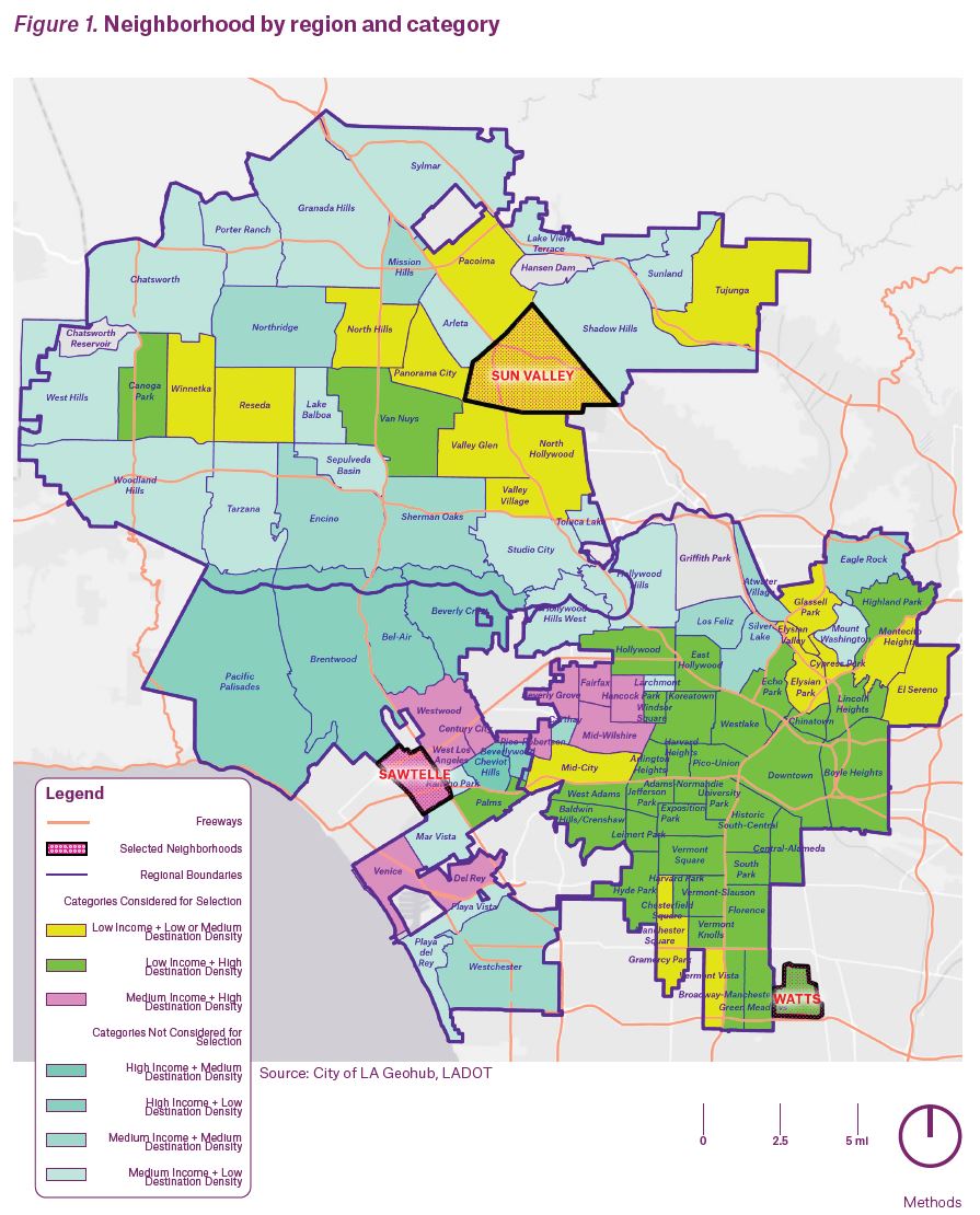
These criteria yielded many neighborhoods within each category. The project team further refined the list of neighborhoods within each category by considering race, ethnicity and access to cars, prioritizing the selection of neighborhoods with high proportions of BIPOC and female workers with no car access. The project team used these factors because existing data demonstrates the intersecting challenges women, girls, and gender and sexual minorities face, particularly low-income and BIPOC women and women without car access.
The resulting study neighborhoods were:
Sun Valley—A low-destination-density, low-income neighborhood in the Valley region
Watts—A high-destination-density, low-income neighborhood in the Central City region
Sawtelle—A high-destination-density, medium-income neighborhood in the Westside region
(See Figure 1. Neighborhood by Region + Category for neighborhood map. See Appendix C for more information on neighborhood ranking and selection process.)
EXISTING DATA SOURCES
Prior to collecting new data, the project team analyzed datasets available from the City of Los Angeles and other sources, including LADOT, Metro, Trust for Public Land (TPL), Bureau of Street Services (BSS), Bureau of Engineering (BOE), Bureau of Street Lighting (BSL) and the US Census Bureau. While some of these datasets included information about gender, not all could be disaggregated by gender at the scale of the study neighborhood. Other data sets did not include gender data, but helped analyze neighborhood conditions and the extent of transportation service relative to other Los Angeles neighborhoods. (See Appendix B: Existing Conditions Report for complete analysis of existing data sources.)
COMMUNITY-ENGAGED DATA COLLECTION METHODS
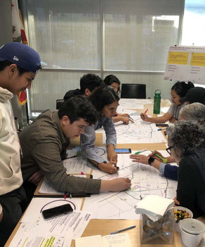
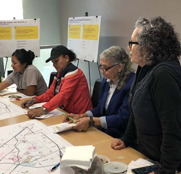
Gender-inclusive data begins with a gender-inclusive process. All data collection efforts engaged and were led by community members in the study neighborhoods. In Sun Valley, the project team partnered with Pacoima Beautiful, and in Watts, the team partnered with Watts Century Latino Organization. These community groups were integral to the process of training and hiring neighborhood residents to complete surveys and travel interviews with members of their community. Although the project team sought a CBO partner in Sawtelle, no potential partner had capacity to serve in this role due to impacts of the COVID-19 pandemic. KDI invited Sawtelle residents to join the neighborhood Working Group through outreach to local businesses, the West Los Angeles Sawtelle Neighborhood Council, schools, churches, and CBOs. Members of the Working Groups—cohorts of residents from each neighborhood that partnered with the research team—were mostly female-identifying adults and they ranged in age, including some high-school-aged youth. Data were collected between July and October 2020.
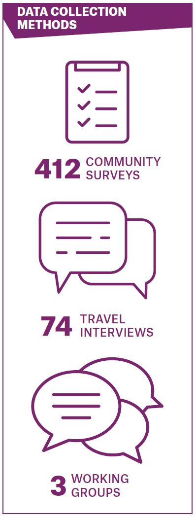
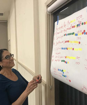
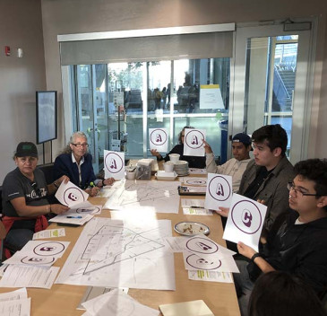
WORKING GROUPS—The project team partnered with residents in the three study neighborhoods to establish Working Groups. In Watts and Sun Valley, CBO partners recruited Working Group members through their organization’s ongoing programs. In Sawtelle, KDI reached out to local organizations like schools, faith-based organizations, and businesses and flyered the neighborhood to recruit Working Group members. Through collaboration with these groups—comprised of 5-8 residents of diverse gender identities, preferred languages, and ages—the project team ensured that the data collection process was shaped by community member expertise and input.
Over the course of 12 meetings, Working Group members provided feedback on data collection methods, helped develop and implement engagement strategies, offered insights into neighborhood context, and vetted findings to ensure they aligned with their lived experiences and perceptions of the neighborhood. Working Group meetings were held in Spanish and English, when applicable, and members were paid for their attendance. Additionally, Working Group members led data collection efforts by administering phone surveys and travel interviews and encouraging their friends, family, and neighbors to participate in the study. The KDI team met with Working Group members in Sun Valley and Watts for an in-person workshop and site visit, respectively, but remaining meetings in these neighborhoods and all meetings in Sawtelle were virtual due to the COVID-19 pandemic.
SURVEY—The project team designed a survey to collect data about community member mobility: how people move around, their experiences traveling, challenges they face, and changes that would improve mobility. Questions covered all travel modes, including driving, public transit, carpooling, rideshare, and active modes. The survey was designed during the beginning of the COVID-19 pandemic, when travel patterns were very different for many and the uncertainty of people’s response was very high. The project team added questions about the impacts of COVID-19, including changes in employment status and potential changes in the use of travel modes, to better understand how the pandemic has affected travel for different groups. (See Appendix A for a full list of survey questions.)
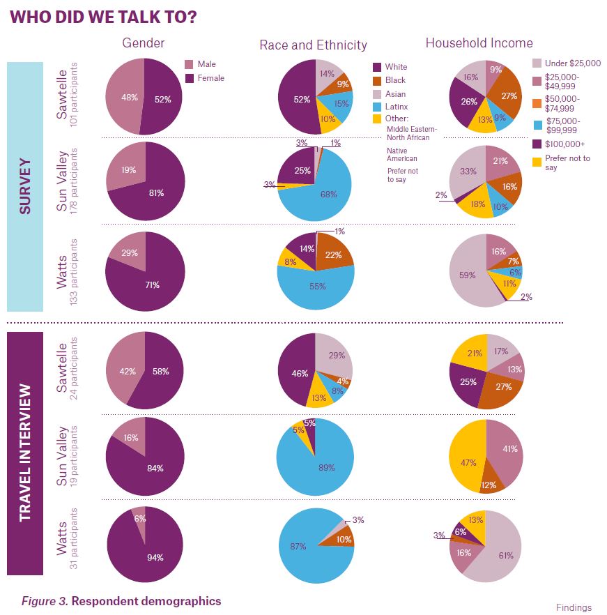
Community members who live, work, go to school, or spend a significant amount of time in the study neighborhoods were eligible to participate in the survey. Four hundred and twelve participants completed the survey: 178 from Sun Valley, 133 from Watts, and 101 from Sawtelle. The project team intentionally oversampled women to address gaps in existing data. As a result, women had a majority voice across the data samples: 82% in Watts, 72% in Sun Valley, and 51% in Sawtelle. The survey required five to ten minutes to complete. All respondents received a $5 gift card and were entered into a weekly $100 raffle.
To protect the health and safety of participants, Working Group members, and the entire community during the COVID-19 pandemic, the project team developed a remote survey engagement strategy, which included a phone option to ensure community members with limited computer literacy or Wi-Fi access were able to participate.
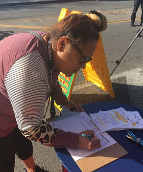
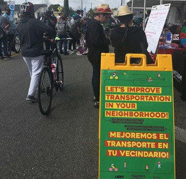
The survey was available in four languages: English, Spanish, Japanese, and Chinese. Participants had the option to take the survey over the phone, online, or on paper at socially-distant, in-person mobile engagements. KDI and CBO partners advertised the survey using the following methods:
- Social media posts and email blasts
- Presentations to community members
- Text messages to residents with the survey link
- Word-of-mouth advertising by Working Group members (Working Group members were paid for every survey completed by a community member they referred)
TRAVEL INTERVIEW—Travel interviews are a qualitative data collection tool used to understand the travel patterns of individuals in greater detail than data derived from surveys. Travel interviews were approximately 30-40 minutes long. Participants answered questions on the following topics:
- Household and demographic characteristics
- Travel behavior to employment, grocery shopping, medical care, childcare, education, and recreation trips
- Care-related trips
- Mode use
- Neighborhood walkability
- Travel impacts and differences related to the COVID-19 pandemic
- Perceptions of and barriers to public transit
- Access to technology
- Trips not taken due to the difficulty of travel
Due to its length and the complexity of questions, the travel interview provides nuanced information and helps fill gaps in existing data about care travel, trip-chaining, intersectionality, opportunity costs of a transportation system that does not prioritize women, and impacts of the COVID-19 pandemic. (See Appendix A for a full list of travel interview questions.)
In total, 74 participants completed travel interviews: 19 in Sun Valley, 31 in Watts, and 24 in Sawtelle. Travel interview participants were recruited in three principal ways: 1) A survey question asking participants to indicate their interest in taking the interview, 2) Text-message recruiting by the project team and CBO partners, and 3) invitations from Working Group members asking friends and fellow community members to participate.
Travel interviews were administered over the phone by Working Group members, LADOT employees, and KDI employees between September and November 2020. Interviewees were compensated $35 for their participation.
A NOTE ON PUBLIC SAFETY SOLUTIONS
Existing research has documented that police presence does not always improve public safety, or perceptions thereof, in low-income, BIPOC neighborhoods. As such, the data collection instruments used in Changing Lanes were designed to understand root causes of perceptions of safety and danger, rather than to solely advance potential solutions like increased
police presence. This strategy provides a foundation for developing safety-related pilot programs in collaboration with communities who have a history of being over-policed. It also recognizes that an increased police presence remains an available option, if of interest to community members.
LIMITATIONS OF DATA
While this study collected a substantial amount of data on the patterns, needs, and concerns of women and men in these selected neighborhoods, the data do present some limitations. While the project team collected a quality sample of data on gendered travel patterns and needs, especially in low-income BIPOC communities, the sample is still relatively small. Additionally, the sample only allowed the project team to compare responses between women and men, and is not inclusive of all gender identities. This sample size limits the analysis in two ways. First, it was difficult to compare and contrast between sub-groups within the dataset. For example, this report could compare patterns between gender and neighborhoods, but it was challenging to examine gender, neighborhood, age, and race because of the small sub-samples. Second, the research team used a convenience sampling approach, which creates a non-random sample of people in these study neighborhoods. The limitation of the sample size and sampling approach is that the results may be hard to generalize to the overall population of Los Angeles.
Going forward, the Department can build on this work by ensuring that projects are sufficiently resourced to collect a sample large enough for analysis through multiple lenses. The Department could also consider strengthening data collection efforts in future studies through the establishment of a demographically representative panel of community members. (See objective A in the Implementation Strategies section for strategies to collect representative data).
AREAS FOR FUTURE RESEARCH
Findings from Changing Lanes underscore the importance of additional study including, but not limited to, the topics listed below:
- Barriers to recreation travel and what would make leisure travel easier
- Trips not taken by women, due to costs of inaccessible, inefficient, or unsafe transport
- Women’s needs, preferences, and interests in bikes, scooters, and other micromobility options
- Travel preferences, needs, and experiences of the LGBTQI+ community
- Travel preferences, needs, and experiences of BIPOC individuals
Because low-income women in BIPOC communities experience the greatest impact of gender-inequities, further study should place an extra focus on these communities.

Before collecting original data, the Changing Lanes project team analyzed existing data to understand differences in demographics, access to transportation services, traffic safety, and built infrastructure across the three study neighborhoods. Taken together, these sources reveal disparities in access to mobility relative to gender.
Data sources include LADOT, Metro, Trust for Public Land (TPL), Bureau of Street Services (BSS), Bureau of Engineering (BOE), and Bureau of Street Lighting (BSL), and the US Census Bureau. Tables 1-4 in the Existing Conditions report (Appendix B) summarize the datasets, including whether the data can be broken out by gender and study area. Since no datasets considered the study area in ways that could be disaggregated by gender (except for Census data), we included relevant non-gendered data. Datasets without gender fields—such as those that identify transit facilities and service—allowed the project team to assess how well-served the study areas are compared to each other and/or to other neighborhoods.
The conditions summarized in this section highlight the importance of intersectionality in gender-inclusive transportation planning. For instance, our examination of Watts revealed a lack of basic on-street infrastructure like crosswalks and signalized intersections and pervasive traffic safety issues. These disparities are consistent with patterns related to race and class. Of the three neighborhoods in this study, Watts has the highest percentage of both Black and Hispanic/Latinx residents, as well as the lowest median incomes across genders. A concerted, long-term investment—one that understands gender, race, and class as inextricably linked—is needed to reconcile the inequities highlighted in this study.
NEIGHBORHOOD DEMOGRAPHICS
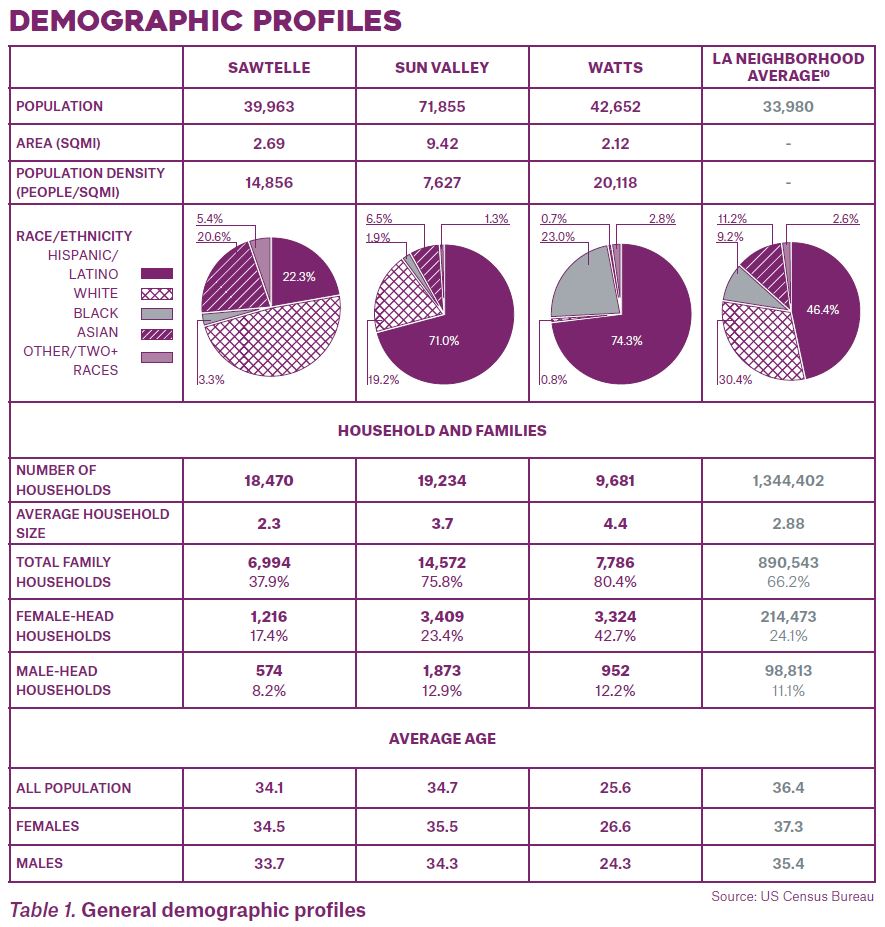
The three study neighborhoods were chosen to represent a demographically-varied cross section of Los Angeles. As noted earlier, Sawtelle was identified as a medium-income neighborhood, while Sun Valley and Watts were identified as lower-income neighborhoods.
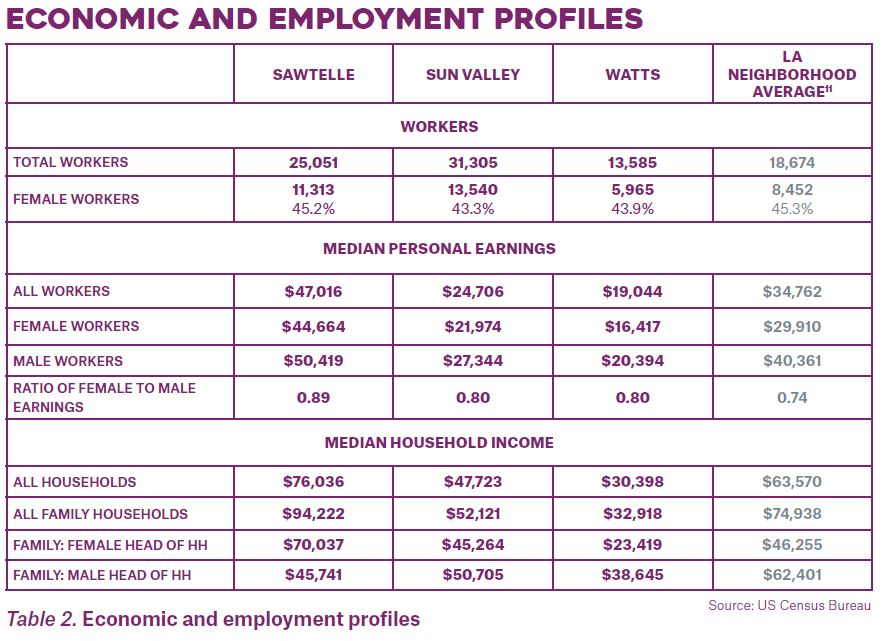
Sun Valley has the largest area, population, number of households, and BIPOC population, all well over the citywide neighborhood average. Sun Valley and Watts have high Hispanic/Latinx populations and Watts has a high Black population and a very low White (non-Hispanic/Latinx) population. Both Watts and Sun Valley have household sizes larger than the city average, and Watts has the highest rate of households with female householders without a husband present among the study neighborhoods, at nearly double the citywide rate. In all three study neighborhoods, the percentage of families with female householders and no husband was higher than that of families with male householders and no wife.
Median personal earnings are lower for female workers than their male counterparts in all three study neighborhoods. Among study participants, Watts residents have the lowest personal earnings for all workers and the lowest median household income. Generally, female-headed households with no husband had a lower median income than their male counterparts, except in Sawtelle, where the former’s household income was significantly higher than the latter’s.
While the median household income in Watts and Sun Valley is in the lowest tercile citywide, the median household income in Sun Valley is about 50% higher than in Watts. When considering the larger average household sizes in Watts, this disparity in household income becomes even more striking.
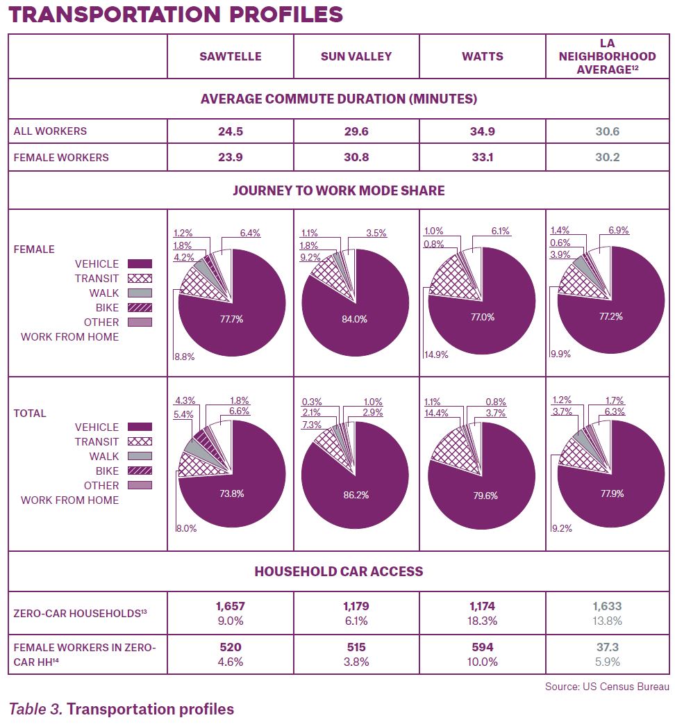
Table 3 describes commuting and transport characteristics of the three study neighborhoods. Commute duration in Sawtelle is lower than average for neighborhoods in the City, and slightly higher than average in Watts. Across the three study areas, there is no clear pattern of one gender having a systematically longer commute. However, the way commute
is defined may exclude commute-related or commute-essential components of a trip chain, such as dropping children off at childcare.
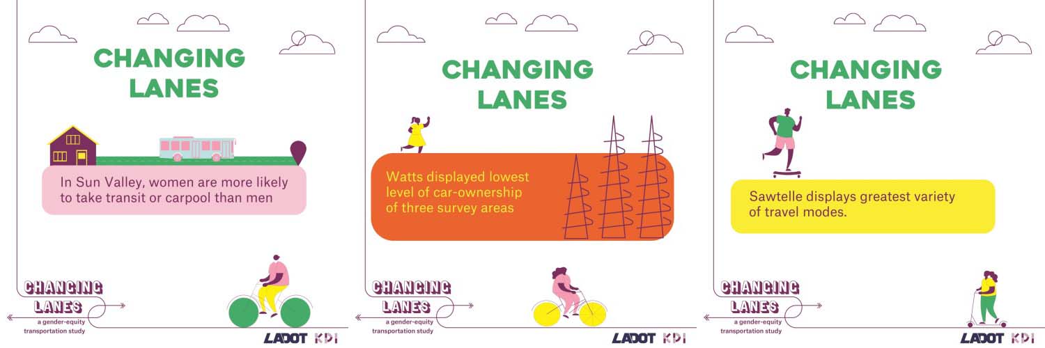
Across the three study areas, women drive and take transit to work at higher-than-average rates for their respective study areas, and are less likely to walk or bike to work. These rates are consistent with existing literature showing a modest gender gap in walking and a larger, more persistent gender gap in bicycling. Additionally, Watts has a higher-than-citywide average transit mode share. Watts has the largest share of zero-car households (18.3%), double and triple the shares for Sawtelle and Sun Valley, respectively. Watts also has the largest percent of female workers living in zero-car households. Sun Valley, the study neighborhood selected to represent areas with lower destination densities, has the lowest share of zero-car households and female workers living in zero-car households.
EXISTING TRANSPORTATION OPTIONS
TRANSPORTATION SERVICES AND MODES
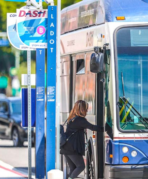
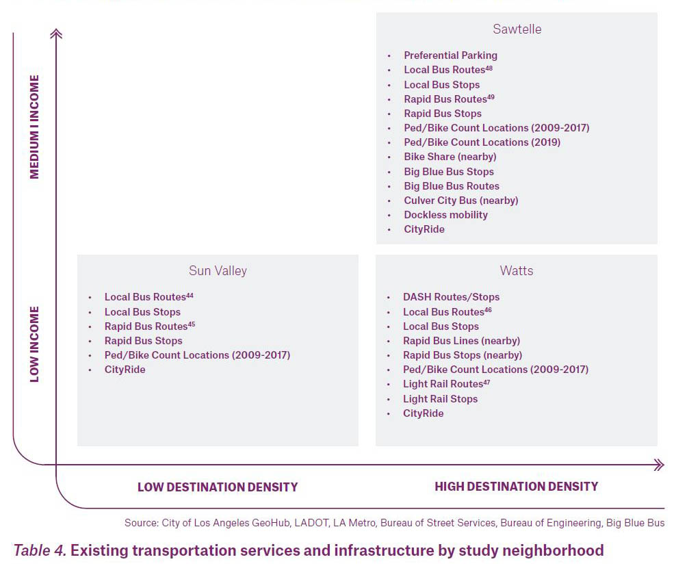
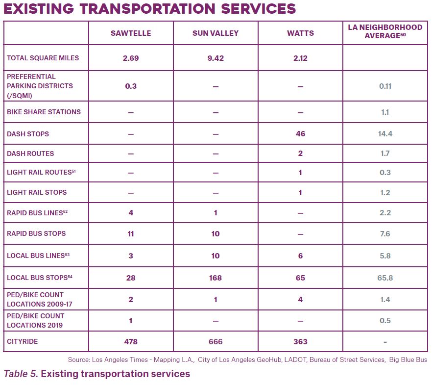
The study neighborhoods vary in their access to diverse travel modes. All study neighborhoods are served by Metro bus routes, but Sawtelle and Watts are served by a greater variety of transportation modes than Sun Valley. This is somewhat expected because destination density is higher in Sawtelle and Watts than in Sun Valley. Watts is the only study neighborhood with a DASH route, a Metro light rail transit stop (on the Metro A Line, also known as the Blue Line), and nearby bus rapid transit. Sawtelle, the study neighborhood with the highest income, is served by various Metro services, including a nearby Metro light rail stop on the Expo line, the City of Santa Monica Big Blue Bus line, and a nearby Culver City bus line. While there are several Metro lines in Sun Valley, each serves a much larger geographic area than in Sawtelle and Watts (Sun Valley is nearly double the size of the other two study neighborhoods).
CityRide provides subsidized shuttle and taxi service for qualified riders citywide, but use is not evenly spread across the study neighborhoods: use in Watts and Sawtelle is roughly 3 and 3.5 times higher than in Sun Valley, respectively. There are no bike-share stations in any of the study neighborhoods, though there are stations near Sawtelle. Although the location of dockless micromobility options like e-bikes and scooters varies, they are generally concentrated in Downtown and neighborhoods to the west, including Sawtelle, and are unavailable in Watts and Sun Valley. Citywide, dockless modes make up a very small share of all trips and current use of these dockless modes is gendered—64% of users identify as male.
BUILT ENVIRONMENT
The study also considers respective differences in built environments (the architectural, infrastructural, and physical characteristics of place). These characteristics affect how residents experience mobility. Sawtelle and Watts are largely composed of compact, dense development, while Sun Valley is characterized by lower-density development. Given these development patterns, some environment characteristics in the three neighborhoods demonstrate a clear pattern of planning inequity.
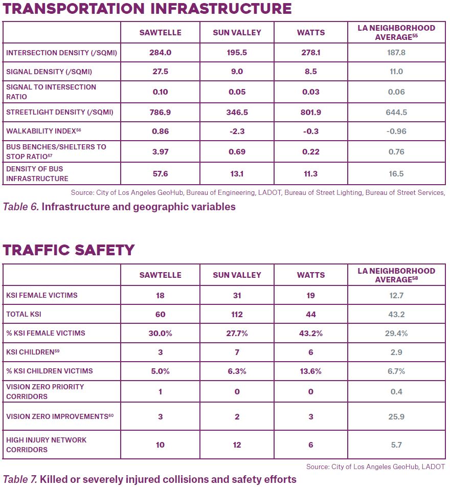
Of the three neighborhoods, Watts, for example, has a higher-than-average density of traffic intersections, but the lowest density of traffic signals, creating a hazardous landscape for pedestrians (see Table 6. Transportation infrastructure). This relative comparison notably includes the more suburban Sun Valley, where one might expect a lower density of signalized intersections than in a denser neighborhood like Watts. In Watts, only one in every 33 intersections is signalized, compared to roughly 1 in 10 in Sawtelle. Additionally, while Watts and Sawtelle share similar patterns of density and compact development, the density of crosswalks per square mile in Watts is slightly over half that in Sawtelle. Collectively, the patterns of signalization and crossing facilities demonstrate that Watts is underserved by basic infrastructure needed to safely cross the street.
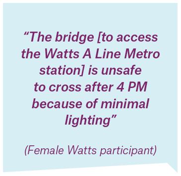
The density of bus amenities—measured by the presence of amenities like bus benches or bus shelters—is also much lower in Watts than in Sawtelle. It is even lower than in Sun Valley, despite Watts having more light rail service, local bus, and DASH bus service. Street lighting, an essential feature of a safe, accessible pedestrian environment, also varies by neighborhood. Watts and Sawtelle have a similar density of streetlights, Watts residents have reported inadequate lighting, noting that the lights may be underpowered or dimmed.
Sun Valley has more bicycle infrastructure than the other study neighborhoods, though many of Sun Valley’s on-street bike lanes are located along La Tuna Canyon Road, which is mainly used for accessing recreational trails. As such, this infrastructure may not adequately serve those who rely on bicycles for everyday travel related to employment, education, shopping, and/or care-giving. For all neighborhoods, the type of bicycle facility is just one of many important factors to consider, including comfort, usefulness, and the extent to which the facility is appropriate for the local context.
Additionally, women’s bicycle travel needs and preferences have been shown to differ from men’s. Research has demonstrated women have greater concerns about personal safety while cycling, especially when cycling in mixed traffic or non-separated bicycle facilities. Women also encounter more street harassment and unwelcome interactions while bicycling, and motorists encroach on female-assumed cyclists more than cyclists assumed to be male.
TRAFFIC SAFETY
Traffic collision data includes information on victim gender and injury severity (the gender field in this dataset is the officer-reported perceived sex, which may not accurately reflect the victim’s gender identity). Although the majority of traffic violence victims killed or seriously injured (KSI) in all three study neighborhoods are male-bodied, the number of female-bodied and child KDI victims was above the citywide average in all three neighborhoods. In Watts, the percent of female-bodied KSI victims (43.2%) was, substantially above the neighborhood average (29.4%). Watts also recorded relatively high percentages of KSI victims under the age of 18–more than twice as rates in Sawtelle, Sun Valley, and the neighborhood average.
To the extent that women’s travel needs imply additional travel time in general or additional time spent as a vulnerable road user, their gender may be associated with an elevated risk of injury or death in a crash. Further, once a crash occurs, research suggests that female-bodied people are more likely to be killed or seriously injured than those with an average male>/q> body type, which is the body type car manufacturers use to design safety features.
BIPOC people and people with low incomes are disproportionately likely to be victims of traffic voilence. This stems from longstanding public underinvestment, which results in inadequate infrastructure like crosswalks and lighting and poor maintenance, inadequate access to health care and biased medical care, racially-biased policing and enforcement, and lower access to newer, safer vehicles, among other factors.
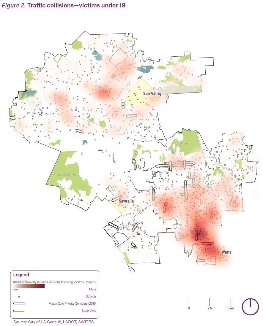
When overlaying the City’s Vision Zero Priority Corridors on KSI data in the study neighborhoods, some geographic differences emerge. There are some similarities between sites where KSI incidents occur, the Vision Zero Priority Corridors appear to align more with the locations of male-bodied KSI incidents. Given the higher number of male KSI victims, this is not surprising. Additionally, children constitute a greater percentage of KSI victims in Watts than on average citywide. This echoes the anecdotes that stakeholders in the neighborhood shared about children being killed or severely injured near schools. Figure 3 shows a heatmap of where KSI collisions with children occur, overlaid with school points.
Twenty-eight neighborhoods throughout the city have at least one Vision Zero Priority Corridor. On average, these neighborhoods have eight High Injury Network segments identified within their boundaries. There were 15 neighborhoods that had more than eight High Injury Network segments and no Priority Corridors, including Sun Valley.

This section outlines the findings that resulted from data collection. The findings are broken up into three sections: 1) findings by gender, 2) findings by neighborhood, and 3) findings related to the COVID-19 pandemic. Each section includes a comprehensive list of statistically significant findings and is followed by a discussion of the implications of those findings.
Taken together, the following findings demonstrate the critical role of income in determining women’s ability to overcome gendered transportation challenges.
Higher-income women can overcome gendered travel challenges by paying for better transportation options or living in neighborhoods with more amenities and mobility options, while lower-income women are trapped depending on systems that do not account for their needs and, as a result, bear greater travel burdens like cost, time poverty, stress, safety risks, or limited access to economic opportunities.
FINDINGS BY GENDER
The gender-based findings in this section reinforce existing knowledge about the differences in women’s mobility compared to men (see Background chapter for list of differences). However, due to data collection coinciding with the COVID-19 pandemic, they also reveal the compounding impact of women’s socio-economic status on mobility and access to opportunity in times of emergency. Women, who are more often essential workers and more often responsible for care-giving and household-related duties, lost their jobs and/or dropped out of the workforce to care for others at higher rates than men.
TRAVEL PATTERNS
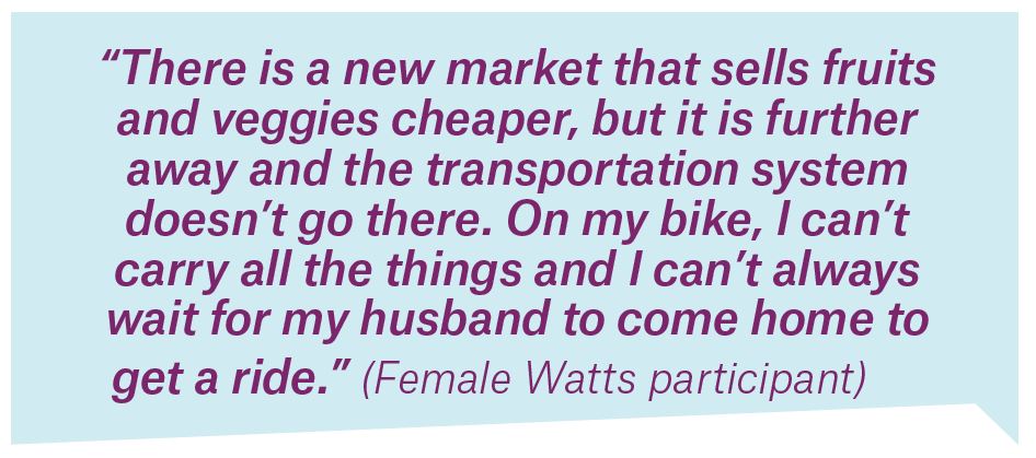
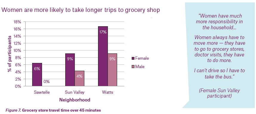
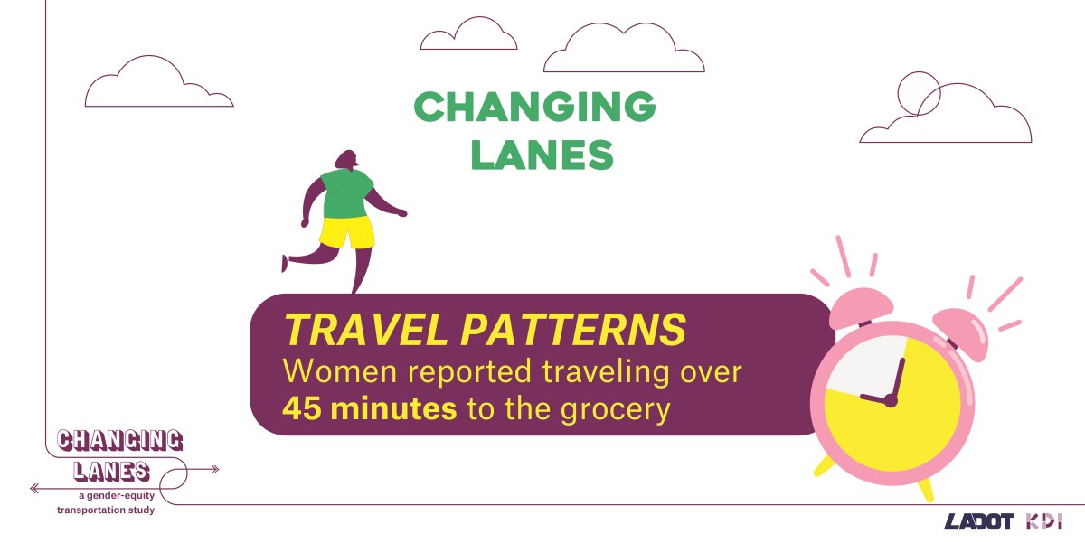
Women are more likely than men to use multiple modes in a day and to trip-chain during trips that do not include commutes. Female respondents in Watts and Sun Valley are more likely to be responsible for household errands like grocery shopping, while male respondents in Sawtelle are more likely to be responsible for those errands. In all three neighborhoods, women are more likely than men to travel over 45 minutes to the grocery store: 6% (Sawtelle), 9% (Sun Valley), and 17% (Watts) of female respondents travel over 45 minutes to grocery shop, compared to 0% (Sawtelle), 4% (Sun Valley) and 9% (Watts) of male respondents. In Watts and Sun Valley, the duration of travel time to the grocery store is tied to car access, with those living in zero-car households most likely to travel over 45 minutes to the grocery store.
MODE USE
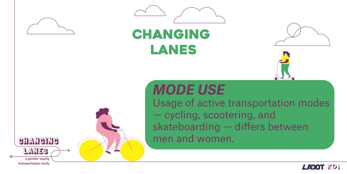
Usage of active transportation modes—cycling, scootering, and skateboarding—differs between men and women. Men, before and during the pandemic, are more likely than women to use active modes. Before the pandemic, 63% of men and 24% of women across all neighborhoods used active modes two or more days a week. During the pandemic, usage decreased to 54% of men and 23% of women. Use of active modes changed less for women during the pandemic than for men, increasing slightly among women in Watts and Sun Valley, while falling among women in Sawtelle. This is in line with LADOT’s Review of the 2019-2020 Dockless Vehicle Pilot Program, which found a higher share of participants who identified as male (64%) than female. Participants also skewed younger and wealthier than the general population.
Women and men drive similar amounts across all neighborhoods. Transit use by gender differs by neighborhood. Before the pandemic, women used transit more frequently (defined by trips per week) than did men in Sun Valley, but men used transit more frequently than did women in Watts and Sawtelle.
BARRIERS TO TRAVEL
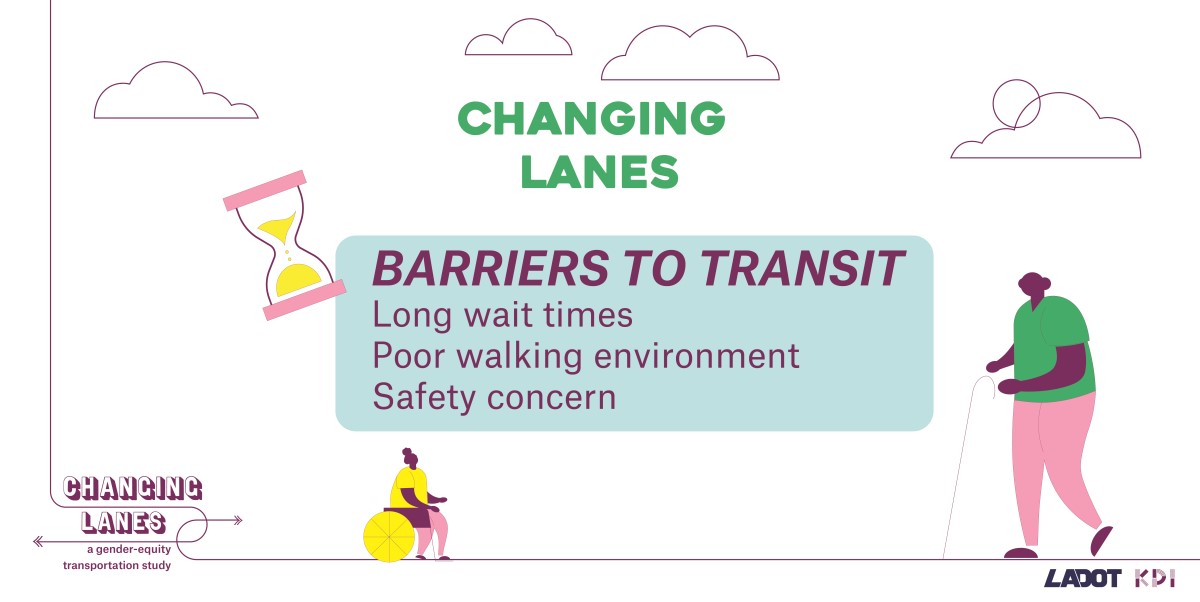
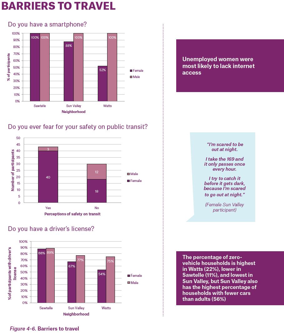
For most modes of transportation, women face varying barriers, including safety concerns, poor walking environments, lower access to driver’s licenses, high costs, and transit inefficiencies such as long travel times and infrequent service. These barriers prevent them from taking trips, making them less mobile than men.
Women are also more likely than are men to be concerned about their safety while using public transit. In addition to gender disparities, there are racial disparities in perceptions of safety waiting for transit, using transit, and walking. Respondents identifying as Latinx, Black, or Asian are more likely than those that identify as White or other to feel unsafe. In addition, women are more likely than men to report transportation as a barrier to recreation trips, which leads women to take fewer recreation trips.
A smaller percentage of female participants have driver’s licenses than do male participants. Sixty-five percent of women surveyed possessed a license versus 82% of men surveyed. Gender disparities in licensure vary by neighborhood. The disparity is greatest in Watts, where 54% of female respondents are licensed compared to 75% of male respondents. In Sun Valley, 67% of female respondents are licensed compared to 77% of men. The gender disparity in licensure is smallest in Sawtelle, where 88% and 89% of women and men are licensed, respectively. Although this study did not collect data on current car-share use, lack of a driver’s license may be a barrier to using car-share services and others that require a driver’s license, especially for women in Watts and Sun Valley where female participants were least likely to have a driver’s license.
In all three study neighborhoods, price appears to be a major consideration in the decision to use ride-hailing services. Sixty-nine percent of men and women surveyed agreed that Lyft/Uber/Taxis are expensive to use.
While men and women in Watts and Sun Valley were equally likely to find these modes expensive, men in Sawtelle were more likely than women to find them expensive. Similarly, 50% of respondents agreed with the statements I walk places to save money
and I take transit to save money,
with Watts residents most likely to agree. In all three study neighborhoods, men were more likely than women to walk and take transit to save money.
WHAT KINDS OF TRIPS DO YOU NOT TAKE BECAUSE TRAVEL IS TOO DIFFICULT?
INTERNET ACCESS
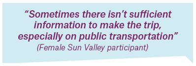
The internet has emerged as a central tool for wayfinding and transit usage. By extension, one’s access to smartphones and the internet is a key determinant of their relative access to mobility. Most travel interview participants had access to a smartphone, computer, and internet at home, but there were significant differences by gender. For example, 0/15 men (0%) lacked a smartphone versus 16/43 women (37%), and 1/15 men (7%) did not have a computer at home versus 18/59 women (31%). Unemployed women were most likely to lack internet access.
IMPLICATIONS OF FINDINGS BY GENDER
The gendered travel patterns found in this study mirror the findings of previous studies. These data demonstrate that, compared to men, women have more complex travel patterns and greater concerns about personal safety, leading to an increased reliance on cars. Low-income women living in low-density neighborhoods also depend on cars to reach destinations located beyond walking distance. Lack of access to cars or lack of a driver’s license can contribute to decreased mobility and/or long, expensive travel for low-income women in low-density neighborhoods as compared to men and higher-income women in these neighborhoods.
In Sawtelle, where the majority of respondents were licensed, there is little to no difference in driver’s licensing rates between genders. Women in Sun Valley and Watts had the lowest rates of licensure compared to their male counterparts. It is likely that the socio-economic and citizenship characteristics of the respondents also affect licensure.
Most participants used cars to reach recreational destinations, and it likely follows that women’s lower access to cars and driver’s licenses inhibits their ability to take these kinds of trips. Limited access to social and recreational destinations like parks and the beach may negatively affect overall quality of life and contribute to social isolation among women and dependents who travel with them, like children and older adults.
FINDINGS BY NEIGHBORHOOD
Women in the three study neighborhoods have different travel patterns and face distinct challenges related to the demographic and built environment characteristics of their neighborhoods. Most significantly, respondents in the majority low-income study neighborhoods of Watts and Sun Valley use fewer transportation modes, are less likely to have car and driver’s license access, and travel longer distances to reach daily destinations compared to women in the higher-income neighborhood of Sawtelle.
TRAVEL PATTERNS
Respondents in the three neighborhoods had different travel profiles. Respondents in Sawtelle, which is a more mixed-use neighborhood than the other two, use a greater variety of travel modes, including driving, walking, biking, and scootering, than do residents of Watts and Sun Valley. Sawtelle residents are also more likely to use active modes than respondents in the other two study neighborhoods. While Sun Valley residents walked the least, Watts residents drove the least and used transit the most. Travel times also varied by neighborhood, with a larger share of Watts and Sun Valley residents leaving for work between midnight and 6:00 AM. This is the case for both men and women in these neighborhoods.
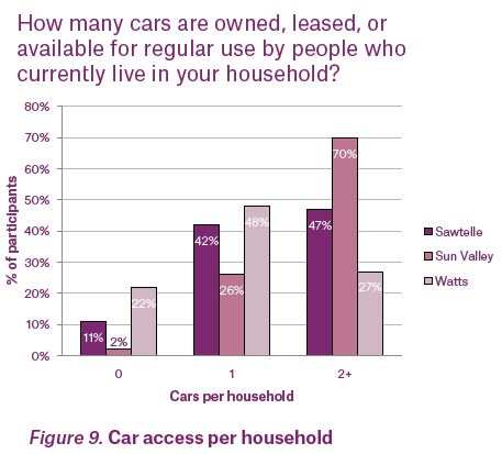
Neighborhood travel differences are connected to a combination of characteristics related to urban form (e.g. density, land use types, proximity to employment centers) and the socioeconomic characteristics of residents (e.g. income, race/ethnicity). In Watts, where residents are mostly low- or very-low-income, households had the lowest levels of car ownership and access to driver’s licenses.
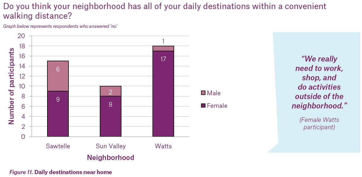
This is represented in the study sample and in community demographics from the American Community Survey. In addition to socioeconomic characteristics, differences in neighborhood land use and development patterns were tied to participants’ ability to access daily destinations. In Sawtelle, respondents were more likely to find all their daily destinations within their neighborhood than were residents of Watts and Sun Valley. In both Watts and Sun Valley, women were less likely than men to be able to access their daily destinations within their neighborhood.
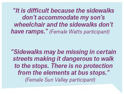
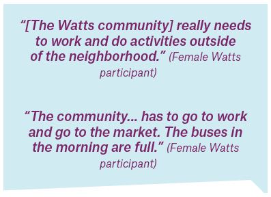
Women face obstacles to walking and taking transit, especially in low-income neighborhoods.
Perceptions of the overall walking environment and the public realm vary by neighborhood, but poor walking environment is the greatest barrier to travel for men and women across all three study neighborhoods. Respondents in Watts and Sun Valley are more likely to report perceptions of danger at night, fear of crime, and poor sidewalk conditions as barriers to walking than are respondents in Sawtelle. Additionally, Sun Valley residents are more likely than Sawtelle residents to report lack of nearby destinations as a barrier.
Across all three neighborhoods, long, unpredictable wait and travel times were also common barriers to using public transit. Watts residents also commonly identified distant stops and indirect service as barriers, while Sun Valley residents commonly identified a lack of bus stop amenities as a barrier. These findings align with previous research that demonstrates frequency of service and travel times as major barriers to using public transit. Service frequency on Metro bus lines is particularly low in Sun Valley, and while lines with frequent service have routes near Watts, not many lines directly serve the neighborhood. Metro bus lines that serve Sawtelle have the highest frequency of service, and the neighborhood is also served by Big Blue Bus and Culver City bus lines. Metro’s NextGen bus plan aims to increase bus frequency and service reliability.
WHAT ARE THE CHALLENGES OF USING PUBLIC TRANSPORTATION?
It’s really hot when I’m waiting
When it rains or there’s a lot of sun, there are no shade structures
Wait times are long
The stops are far
Walking to the stop
It takes a lot more time
You have to plan your day more accordingly
You have to transfer
Can’t bring [a] bike...because of the capacity and infrastructure of the transit system
I’ve been volunteering...but to get there is such a nightmare on public transit...one time it took over 3 hours...Time is the biggest issue, and frequency...[and] no shade at bus stops.
IMPLICATIONS OF FINDINGS BY NEIGHBORHOOD
The data do not indicate why people only use specific modes or if their modal use reflects preferences or constraints. Given the distinct travel differences across the three neighborhoods, however, the data suggest that solutions for the mobility needs of women must be neighborhood-appropriate. Low-income, low- and medium-density neighborhoods will require different transportation interventions than higher-density areas.
The travel behavior of respondents in Sawtelle, for instance, demonstrates that improving mobility through more modes of transportation is easier when destinations are closer together; when travelers are more familiar and comfortable with transit services; when residents have the financial resources to use technology-based services; and when there is widespread access to driver’s licenses.
The types of interventions necessary in medium- and lower-density areas should likely target the ability to travel longer distances than are easily covered by walking, scootering, or bicycling. This may also be true in neighborhoods with high-destination-density, but where residents may still have to travel outside their neighborhood to reach jobs and certain types of destinations, such as retail or cultural and/or entertainment destinations.
Without improving the accessibility of nearby destinations in communities like Watts and Sun Valley through land use planning, design, and development efforts, the usefulness of walking and bicycling will be limited, regardless of how safe the streets are. Similarly, until public and active modes better serve women’s travel needs, car travel will remain the most efficient way to meet women’s travel needs, especially in low-income, BIPOC communities affected by historic divestment in public transit and the pedestrian environment. Potential interventions must also recognize the cost barriers of using ride-hailing services among low-income people. Additional research in South Los Angeles found the fluctuating prices in demand-driven models used by some rideshare and micromobility services like bike- and scooter-share is a barrier to use among mothers.
COVID-19 PANDEMIC FINDINGS
The pandemic affected travel patterns in all three study neighborhoods, but changes were less pronounced in the low-income study neighborhoods. Although transit use declined in all three neighborhoods, it declined the least in Watts. Across the three neighborhoods, respondents in Sawtelle experienced the largest increase in walking during COVID. Respondents in Watts walked less during the pandemic than they did previously.
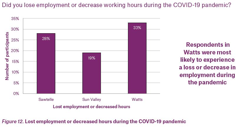
Across the three neighborhoods, Watts respondents suffered the greatest job losses as a result of the COVID-19 pandemic. Overall transit use, however, did not change for the majority of Watts respondents who lost employment. Among the relatively small group of newly unemployed Watts residents for whom transit use did change, ridership was more likely to increase.
Pandemic-related changes in employment affected women more than men. Twenty-nine percent of female survey participants lost employment or decreased working hours, compared to 18% of male survey participants. Nationally, a study from the University of Minnesota found that female employment dropped more sharply than male employment in general during the pandemic (2.2% versus 1.6%), especially among mothers. Unemployment due to COVID also remains more pronounced for Black men and women compared to White working-age people. State-level employment data for California during the pandemic demonstrates a similar trend, with 19% of women being unemployed or under-employed, compared to 16% of men. Despite modest employment gains in summer 2020, women’s participation in the labor force stagnated in the fall.
IMPLICATIONS OF COVID-19 PANDEMIC FINDINGS
Although the COVID-19 pandemic has affected travel patterns across all three study neighborhoods, its impacts have been uneven. Transit use in Watts has changed the least across respondents in the three neighborhoods, while walking in Watts has declined during the pandemic. This is consistent with research conducted in Chicago, which found that transit ridership declines are lowest among low-income, BIPOC communities, who disproportionately work as essential workers and cannot work from home during the pandemic.
Job loss among women during the pandemic may also be exacerbated by the demands of remote learning and childcare responsibilities often borne by mothers. Of the three study neighborhoods, respondents in Watts suffered the greatest pandemic-related job losses. Despite job loss, transit use among the majority of Watts residents who lost employment remained unchanged.
Job loss among women during the pandemic may also be exacerbated by the demands of remote learning and childcare responsibilities often borne by mothers. Of the three study neighborhoods, respondents in Watts suffered the greatest pandemic-related job losses. Despite job loss, transit use among the majority of Watts residents who lost employment remained unchanged. Although we did not collect data on why Watts residents who lost employment continued transit use, it may be connected to low levels of car access and ownership and the limited number of daily destinations in the neighborhood, which forces residents to use transit to reach shopping and other non-employment-related daily destinations. Respondents in Sawtelle walked more during the pandemic, but this increase in walking did not occur in the other two neighborhoods. This is likely attributable to fewer destinations accessible by foot and different perceptions of safety and comfort walking in Watts and Sun Valley compared to Sawtelle.

INTRODUCTION
The recommendations in this section provide guidance on how to make the City’s transportation system more equitable. It is presented in three parts:
Key Commitments — Core principles to guide a systemic change toward gender-inclusive planning across the Los Angeles Department of Transportation (LADOT).
Foundational Steps — Initial actions that set the stage for later work aimed at practical, holistic, and actionable changes to render Los Angeles’ transportation system more equitable.
Implementation Strategies — A set of specific actions across four focus areas: data, infrastructure, services, and programs. Taken together, these actions will begin to make all aspects of LADOT operations more gender-inclusive.
KEY COMMITMENTS
Because business-as-usual has resulted in gender-related transportation inequities, LADOT must adopt an innovative approach to build a truly gender-inclusive transportation system. To ensure all parts of a project’s life cycle are gender-inclusive, commitments to participatory processes, cross-sectoral integration, resourced community partnerships, sustained investment, and knowledge building must guide all LADOT projects from design through evaluation. These commitments establish the groundwork needed to achieve the goals laid out in the implementation strategies.
PARTICIPATORY PROCESSES
Gender-inclusive processes establish the priorities of women, girls, and sexual and gender minorities to ensure projects and programs are adequately designed to address residents’ most pressing challenges. Gender inclusion means actively embedding the voices of women, girls, and sexual and gender minorities across all of LADOT’s critical decision-making processes. LADOT and its partners must commit to respecting, seeking out, and valuing community knowledge as of equal priority as technical expertise.
CROSS-SECTOR INTEGRATION
Because gender inequity is a cross-cutting issue, approaches to gender-inclusive transportation must integrate a full range of sectors to address root causes. Multiple agencies provide the infrastructure and services women use in a single trip, so LADOT must commit to partnering with transportation-related agencies at City, County and Regional levels to address gender inequities across the larger transportation system. Further, LADOT must forge lasting partnerships across disciplinary silos because women’s mobility is affected by housing, land use, and city planning.
RESOURCED COMMUNITY PARTNERSHIPS
In order to develop gender-inclusive solutions that are appropriate for the communities that most stand to benefit, LADOT projects and programs must be designed, implemented, and evaluated through long-term, funded partnerships with CBOs that serve women, girls, and gender and sexual minorities.
SUSTAINED INVESTMENT
To make LADOT’s system truly gender equitable, changes will need to be more than adjustments or add-ons to existing budgeting and operations. It will necessitate a fundamental reshaping of processes. Gender-inclusive transportation planning and design demand and require an organizational commitment to additional and dedicated, human and financial resources from project development to delivery and through maintenance and operations.
EQUITABLE DELIVERY
Urban inequities result from generations of injustice and disinvestment. To move toward greater equity, therefore, LADOT must first consider investments in those neighborhoods that have long been overlooked by public funding: low-income BIPOC communities. To do this, the Department and its peers must shift practices, where necessary, and commit to investing in communities with the highest needs, rather than the loudest voice.
KNOWLEDGE BUILDING
To ensure LADOT and its partners continue to refine best practices for gender-inclusive transportation planning, all LADOT projects must be evaluated with a rigorous monitoring, evaluation, accountability, and learning (MEAL) framework based on gender-disaggregated indicators. MEAL frameworks should be developed and implemented in partnership with CBOs that serve women, girls, and gender and sexual minorities. This process will yield projects more closely responsive to local community needs.
EQUITABLE CITYWIDE IMPLEMENTATION ROADMAP
For generations, low income communities of color throughout the United States have, as a matter of policy, received disproportionate resources, resulting in disparities not only in transportation options, but also in housing, public space, education, and employment. The data collected in this study confirm the conclusion that Los Angeles has not been immune from this national trend. The low-income communities of Watts and Sun Valley, for instance, experience stark disparities in public assets—fewer crosswalks, limited signalized intersections, and sparse bus amenities—when compared to the higher income neighborhood of Sawtelle. This section outlines an implementation roadmap to reverse this trend, ensuring that transportation is gender equitable and meets the needs of all Angelenos.
To do this effectively, any plans must prioritize resources in low-income communities of color, which have been subject to generations of disinvestment. In making much-needed improvements in communities that need them most, LADOT can simultaneously accomplish multiple goals: infrastructure and service upgrades and gender equity.
By addressing gender equity in neighborhoods already well serviced by transportation options and quality infrastructure, LADOT would risk squandering resources, deepening existing divides, and inhibiting residents in high-need communities from accessing the benefits from this study. For example, a citywide program intended to increase walking and bicycling might have limited effectiveness in low-income BIPOC communities, which have long been overlooked by infrastructure investments, resulting in neighborhoods that lack basic features—crosswalks and bicycle lanes—to make such a program safe and effective.
Once high-need neighborhoods have been made more equitable, LADOT can implement gender-equity initiatives across the entire city.
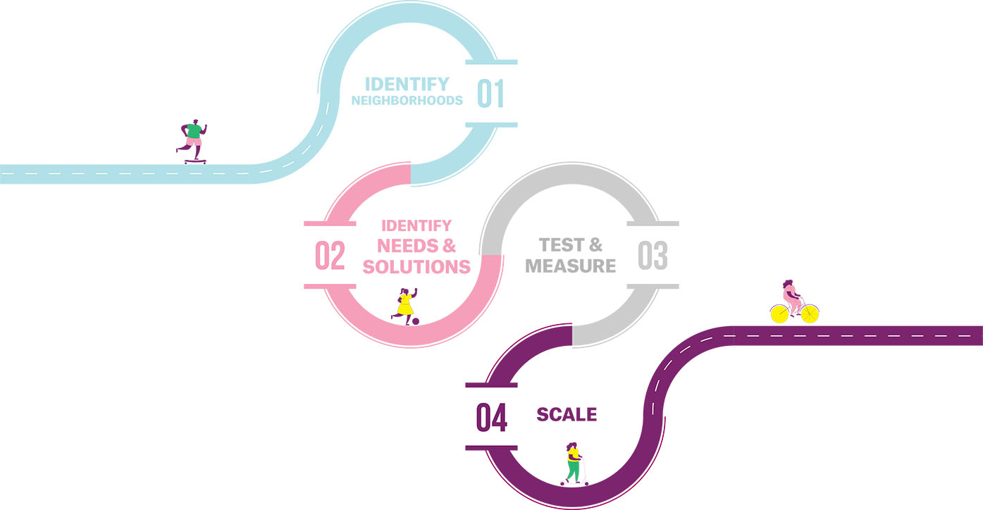
FOUNDATIONAL STEPS
In order for the Department to start any one project or plan, certain inital actions must be taken to ensure holistic, impactful, and equitable results.
Failure to take these steps risks the creation of piecemeal projects that do not align with the ways women travel. An uncoordinated approach also leaves planners to guess at user needs, rather than hearing about them first hand, putting our city further behind in achieving gender, racial, economic, and environmental parity for all Angelenos. These steps are intended to transform the way the Department works from the inside out, focusing on internal standards and processes:
Collect data on gender or perceived gender, race/ethnicity, and other intersecting identities like income, ability, and age in all data collection efforts, including efforts to track ridership, user experience, service and program evaluation, and bicycle and pedestrian counts. Data collection efforts should include qualitative data like community member stories and narratives.
Convene representatives from built-environment-focused government agencies in a gender-equity working group to coordinate projects, services, and programs that impact the built environment and transportation system. Essential departments for the working group include, but are not limited to:
- Bureau of Street Services (BSS)
- Bureau of Street Lighting (BSL)
- Bureau of Engineering (BOE)
- City Planning
- Metro
- Recreation and Parks (RAP)
Create participatory processes to operationalize the Department’s commitment to sharing decision-making power with women, girls and gender minorities—specifically low-income BIPOC women—for all planning and design efforts. Develop internal resources such as a framework, handbook, or other guides to help staff execute participatory processes. To further support this process, establish and resource lasting partnerships with CBOs and residents that are maintained on an ongoing basis, not solely when projects are happening.
Develop a gender and racial equity-based project prioritization framework that guides staff on where to focus capital investments and resources. As part of the framework, develop a set of equity criteria and a methodology for evaluating that criteria.
Establish new design and service standards and guidelines that accommodate the ways that low-income BIPOC women, girls, and gender minorities travel and improve safety while traveling. This guide should set standards for a range of factors, including but not limited to sidewalk width, frequency of transit, prevalence of stops/stations, night-time visibility, and fleet/vehicle design.
HOW TO READ THE IMPLEMENTATION STRATEGIES
The implementation strategies section contains nine objectives across four categories. Each objective is supported by action items to create a gender-inclusive transportation system.
- Closing the Data Gap outlines ways to make better decisions with data.
- Inclusive Infrastructure describes how the built environment should inform transportation decisions and how the built environment can be improved to increase women’s mobility.
- Services offer guidance on how to improve existing services and add new options that better meet the needs of women.
- Programs offer ideas for how public initiatives can work alongside infrastructure and mode options to increase women’s mobility, particularly low-income BIPOC women.
Within each category, there is a list of high-level objectives and subsequent activities that help achieve that objective. Some of the implementation strategies do not directly fall within LADOT’s jurisdiction. For these strategies, we suggest agencies and organizations with whom LADOT might partner (see page 57). These strategies include partnerships with some of the following outside agencies and/or CBOs to help Angelenos make better use of LADOT’s system.
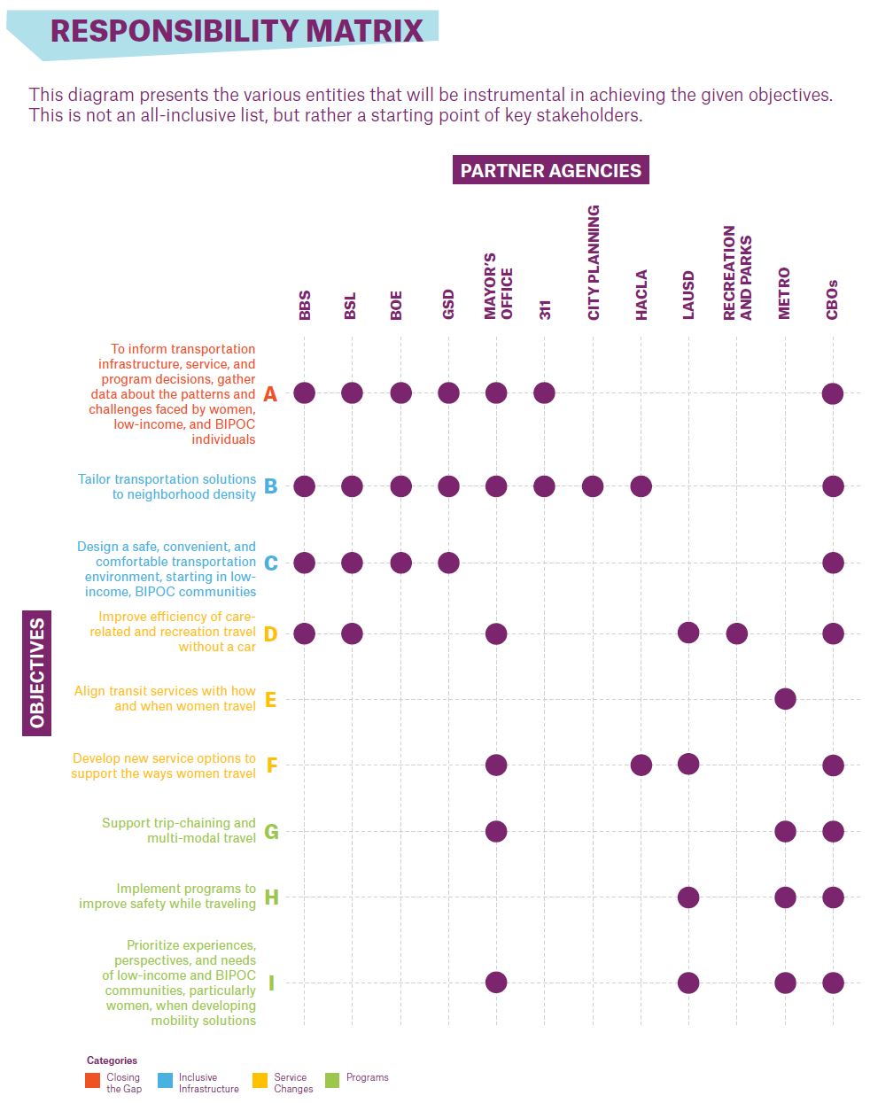
OVERVIEW OF PARTNERS
- 311 - The 311 Call Center connects callers to non-emergency City services and provides general City information. Angelenos can also use the MyLA311 app to request non-emergency services like pot-hole repair, bulky item pick-up, and more.
- Bureau of Street Services (BSS) - maintains, repairs, resurfaces, and cleans improved streets, alleys, bridges, tunnels, pedestrian subways, and related structures. BSS also oversees design and construction management services for streetscape projects.
- Bureau of Street Lighting (BSL) - provides engineering, design, construction, maintenance, and repair of the City’s Street Lighting System, including maintaining adequate roadway and sidewalk illumination for vehicular and pedestrian safety, estimating costs for new installations, and assessing maintenance
- Bureau of Engineering (BOE) - responsible for the design and construction of public works projects and private development affecting the public right of way for the City, as well as reviewing engineering features and standards of all privately developed subdivisions and tracts, issuing permits for work, surveying, and more.
- City Planning - creates and implements plans, policies and programs that realize a vision of Los Angeles as a collection of healthy and sustainable neighborhoods, each with a distinct sense of place, based on a foundation of mobility, economic vitality and improved quality of life for all residents.
- Community Based Organizations (CBOs) - a non-profit organization that represents a community or segment of a community and provides resources and services to that community
- General Services Department (GSD) - provides centralized support services to City departments, elected officials, and non-City organizations, including purchasing, materials management and warehousing, mail and messenger services, maintenance and repair of the City’s vehicle and helicopter fleet; testing of soils, asphalt, and building construction materials; printing and duplication services; construction and maintenance of City-owned buildings; property leasing and management, custodial, recycling and moving services, security; parking services for City facilities; and coordination of and logistical support for special events
- Housing Authority of the City of Los Angeles (HACLA) - provider affordable housing and rent assistance to low and very low-income households and economic development, employment, education and social programs.
- Los Angeles County Metropolitan Transportation Authority (Metro) - provides regional transportation planning services and operates rail and bus service throughout Los Angeles County
- Los Angeles Unified School District (LAUSD) - public school district providing K-12 educational services within the city of Los Angeles and all or part of 31 cities and unincorporated communities in Southern California.
- Mayor’s Office of City Services (MOCS) - oversees projects to improve roads, bridges, bus lines, public transit network, water infrastructure and waste management systems; MOCS also oversees Departments related to arts and culture, environmental conservation, aging, immigration, and youth development.
- Recreation and Parks - operates and maintains over 420 parks on more than 15,000 acres of parkland, as well as 184 recreation centers, 2 state licensed child-care centers, and 31 senior centers. Other Department facilities include golf courses, play areas, sports fields, swimming pools, hiking trails, beaches, museums, historical sites.
CLOSING THE DATA GAP
Objective A: To inform transportation infrastructure, service, and program decisions, gather data about the patterns and challenges faced by women, low-income, and BIPOC individuals
PARTNERS: BSS, BSL, BOE, GSD, MAYOR’S OFFICE, 311, CBOs
- Adapt current data and establish new data collection efforts to ensure the inclusion of gender or perceived gender, race/ethnicity, and other intersectional identities like income, ability, and age.
- Collect data on the quality of infrastructure using LADOT data collection efforts, sensors, and, when relevant, paid community reporters and neighborhood walking audits to set and measure data against established benchmarks, especially along routes women, girls, and gender minorities use most. LADOT and partner agencies should consider a public education campaign within low-income neighborhoods to increase use and accessibility of 311 for the reporting of infrastructure maintenance needs. At a minimum, data should measure:
- Sidewalk quality and width
- Percentage of curbs with accessible curb cuts
- Intensity of and distance between lighting
- Accessibility of sidewalk egress, including any barriers from micromobility infrastructure or debris
- Street crossing safety, including crosswalk width and timing and street traffic speeds
- Maintenance of sidewalks and curbs
- Street trees
- Street cleanliness
- Street furniture and seating
- Public art along routes
- Number of miles of connected pedestrian network
- Engage Community Based Organizations (CBOs) involved in gender-, race-, sexuality-, age-, and disability-based advocacy to identify key issues and specific concerns. Potential methods to improve inclusion of women, gender minorities, low-income, and BIPOC residents may include:
- Conduct walk audits with women of a range of racial, age, and ability identities.
- Place paper surveys, available in multiple languages, in places of employment and community institutions.
- Conduct surveys, travel diaries, and interviews at community anchors, such as schools, churches, daycares, and laundromats, including questions relevant to women’s travel, like sexual harassment in transit settings.
- Conduct transit station-based data analysis using crowd counting, surveys, etc., especially during off-peak travel.
- Establish a peer-to-peer learning network to raise awareness of and improve transportation solutions.
- Increase access to internet, computers, and smartphones necessary to participate in data collection.
- Deploy pop-up and mobile engagements to record resident narratives about transportation experiences and needs
CASE STUDY: GENDER-DISAGGREGATED DATA COLLECTION AND ANALYSIS
Transport for London (TfL), the City of London’s municipal transportation agency, conducts the London Travel Demand Survey (LTDS) every year to understand the travel behaviors and experiences of London residents. The survey collects data on the travel patterns, experiences, perceptions of safety and comfort,
access to information, fare payment methods, and barriers to transit use, as well as the participant’s gender, race, ethnicity, ability, and age. Findings are published in an annual report and inform the TfL’s annual reporting on the agency’s diversity and inclusion goals.
INCLUSIVE INFRASTRUCTURE
Objective B: Tailor transportation solutions to neighborhood density
BSS, BSL, BOE, GSD, MAYOR’S OFFICE, City Planning, HACLA, CBOs
- In low- and medium-density neighborhoods, where destinations and opportunities are further away, focus strategies on expanding access to transportation modes better suited to long distance travel like automobiles and public transit, understanding that the ability of public transit to meet women’s complex travel needs may remain limited in these areas.
- Bring resources to low-income, low-density communities to reduce travel burdens for women.
- In the short term, bring mobile resources to underutilized spaces (parking lots and empty lots, for example) and community anchors (such as schools and places of worship). These resources may include: mobile health clinics and telehealth stations, mobile libraries, affordable and healthy grocery stands, legal aid resources, and recreation programs.
- To implement long-term solutions, partner with the Department of City Planning and other agencies that inform land use development to encourage the
15-minute city,
promoting the location of destinations to which women most often travel, such as healthy grocery stores, libraries, clinics, recreation opportunities, childcare facilities, and essential services in close proximity to housing.
- Since automobiles accommodate trip-chaining better than other modes, partner with other agencies and CBOs to improve women’s access to driver’s licenses and vehicles that accommodate long trips.
- Expand BlueLA service and charging infrastructure to medium and low-density and low-income communities like Watts and Sun Valley.
- Bring resources to low-income, low-density communities to reduce travel burdens for women.
- In high-density, mixed-use neighborhoods with multiple destinations located within ¼-½ miles, focus strategies on increasing walking, bicycling, and other active modes.
CASE STUDY: LADOT PLAY STREETS PROGRAM
LADOT’s Play Streets program enables Los Angeles residents to temporarily close their neighborhood streets and convert them into public spaces for play, exercise, and gathering. The program brings amenities and recreational opportunities for all ages to their doorsteps,
reducing the travel burdens associated with accessing recreational space. The program is particularly impactful for parents and caretakers who have dependents and in communities where recreation spaces are lacking.
Objective C: Design a safe, convenient, and comfortable transportation environment
PARTNERS: BSS, BSL, BOE, GSD, CBOs
- Increase street lighting, particularly in and around bus stops, shade cover, and the amount of street furniture.
- Repair and widen sidewalks, such that a person with a stroller, wheelchair, or dependent can easily pass.
- Increase the amount of crosswalks and crosswalk signal frequency and duration in infrastructure-deficient neighborhoods.
- Place bus stops near active businesses and/or other active uses, and install key infrastructure at transit stops, such as seating and trash cans.
- Accommodate traveling with dependents and/or older adults, including priority seating on transit, space for stroller storage on transit, car seat availability in vehicles and child-seats and cargo racks/baskets on bikes/e-bikes, among other accommodations.
CASE STUDY: MARIAHILF DISTRICT IN VIENNA, AUSTRIA
The transportation infrastructure and public spaces in Vienna’s Mariahilf District were designed to be safe, comfortable, and accessible for those of all genders. After studying gendered transportation patterns, the City piloted a set of gender-inclusive transportation planning and design improvements in Mariahilf between 2003 and 2005, including widening 1,000 meters of sidewalk, adding 40 street crossings, and building 5 pedestrian ramps and staircases that accommodate strollers and carts. Mariahilf’s main commercial corridors are pedestrianized, open only to walkers, cyclists, transit, and pick-up, drop-off traffic. Main thoroughfares include ample lighting and street furniture like benches, tables, and public waste receptacles.
Public transportation stops are located near active uses like shops and active street corners for safety, and elevators accommodate pedestrians and transit riders with limited mobility or traveling with dependents. The Mariahilf pilot project provided a template for future citywide gender-inclusive transportation planning and design guidelines. Since adoption, the guidelines have had both tangible and intangible impacts: 35,000 public lights (23% of all in the city), 60 crosswalks, and a half mile of sidewalk pavement have been improved or installed among other improvements, and perceptions of safety among Vienna residents have increased 6% among both men and women.
SERVICE CHANGES
Objective D: Improve efficiency of care-related and recreation travel without a car
PARTNERS: RAP, CBOs, LAUSD, MAYOR’S OFFICE
- Work with women in low-income neighborhoods, particularly women who care for others like children or elderly dependents, to design a weekend, point-to-point transit shuttle service that connects them to recreation and open-space opportunities, especially to and from beaches.
- Partner with relevant government agencies and CBOs to incentivize child-care and pre-K providers to provide home or neighborhood-based pick-up and drop-off services for children to reduce women’s travel to and from childcare services and improve access to childcare and pre-K.
- Partner with relevant government agencies and CBOs to incentivize youth recreation service providers (community centers, sports leagues, and arts and cultural centers) to provide home- or neighborhood-based pick-up and drop-off services for youth. This will not only increase access for youth, but it will also reduce women’s obligation to travel to and from such activities.
CASE STUDY: HOLLYWOOD BOWL PARK AND RIDE SHUTTLE
The Hollywood Bowl Park and Ride Shuttle program offers a local example of a recreation-focused point-to-point shuttle service. The Shuttle provides a connection to-and-from the Hollywood Bowl from pre-determined Park and Ride parking lots throughout the Los Angeles region. Park and Ride lots are subject to change, but they are generally distributed throughout the Los Angeles region and all lots are wheelchair accessible.
Shuttle departures begin 2.5 hours before a scheduled show and continue every 10-15 minutes until the show begins, in addition to providing post-show return shuttle service. The Hollywood Bowl Shuttle offers flexible ticket payment options, including phone, online, and on-board cash purchase.
Objective E: Align transit services with how and when women travel
PARTNERS: Metro
- Partner with Metro to better connect DASH to the most frequently-used transit locations in communities to make trip-chaining more efficient and affordable using public transit. While it may not be possible to remove all the barriers to trip chaining using public transit, improved integration across transit services is a first step toward improving women’s ability to trip-chain on public transit, in concert with improving access to other modes well suited to trip-chaining like car- and van-share.
CASE STUDY: REGIONAL TRANSIT SERVICE INTEGRATION
To address route redundancy, service schedule conflicts, and confusing fare structures, Hamburg German’s transportation agencies formed a regional alliance to integrate policy and services, adopt a uniform fare structure, and coordinate schedules and routes. As a result, agencies optimized routes, filled service gaps, and reduced overall wait times for riders. Service coordination resulted in a 14% increase in ridership.
Over time, Hamburg’s regional transport alliance has helped the city adapt to and integrate new modes into the mobility landscape, ensuring car-, bike-, and ride-share services are available in areas without robust transit access. Payment is also integrated across transportation modes--users can pay for all services using a single card. Similar initiatives have been rolled out in Phoenix, Arizona, Seattle, Washington, and other US cities to much success.
Objective F: Develop new service options to support the ways women travel
PARTNERS: HACLA, CBOs, LAUSD, MAYOR’S OFFICE
- Partner with CBOs, housing authorities, and affordable housing developments to pilot non-profit van- and car-sharing models in low-income, BIPOC communities. Potential pilot models include: 1) non-profit community-based model (operating van- and car-share programs out of CBOs and local institutions, such as places of worship), and 2) housing amenity model (operating van- and car- share programs at housing sites for residents).
- Assess community interest in and the feasibility of a neighborhood-based dial-a-ride service that provides reliable, high-quality, and safe travel and employment opportunities for women in low-income communities. Capitalize on informal car-pooling and hire women from the neighborhood as drivers and support staff.
- Facilitate workshops with women to understand their needs and preferences for using scooters and bicycles, as these modes may provide a great deal of mobility for women’s local travel needs, yet are mostly used by men. Hosting events like CicLAvia in these neighborhoods is an opportunity to engage with women and girls who do not typically use bicycles, but might be interested in trying them in a safe environment and recruit participants for future focus groups to better understand barriers to using scooters and bicycles.
CASE STUDY: MÍOCAR CAR-SHARING
Míocar is an electric vehicle car-sharing service piloted in 2019 in low-income communities in Kern and Tulare Counties with low-levels of car and public transit access. Míocar is non-profit and is funded by Cap-and-Trade revenues through the California Air Resources Board. Míocar makes car-sharing accessible for low-income community members by placing cars and charging stations at affordable housing developments--they are available at 8 developments in 6 low-income communities. To raise community awareness about the potential benefits of car-sharing and how to use the program, Míocar partnered with CBO Self-Help Enterprises to provide orientations and help community members get comfortable with the service.
The Míocar pilot demonstrates its potential to improve quality of life and access to opportunity for low-income women. Frequency of Míocar use is inversely related with income and car access and is highest among households with households that lack access to a vehicle, have 3 or more adults, and include adults that earn $15,000 or less annually. Additionally, family and personal errands accounted for nearly 40% of Míocar trips, while work-related and social/recreational trips were the second and third most important reasons for Míocar trips, respectively. Results from the pilot also demonstrate that Míocar was not used as a substitute for public transport, but helped address existing transportation inequities.
PROGRAMS
Objective G: Support trip-chaining and multi-modal travel
PARTNERS: Metro, CBOs, MAYOR’S OFFICE
- Implement programs that help low-income, BIPOC women gain access to driver training and driver’s licenses.
- Partner with CBOs already assisting women to host workshops with women interested in getting their driver’s license and to raise awareness among undocumented women about their eligibility to receive a California driver’s license under a recently passed law (AB60).
- Enable free transfers between micromobility, LADOT, and Metro for more affordable and seamless trip-chaining.
- Implement a low-income transportation cash support program that women can use on any mode that best matches their travel needs, including modes other than transit like rideshare, to provide low-income women greater mode flexibility and to compensate for the disproportionate time and cost of travel that women experience.
CASE STUDY: INCREASING ACCESS TO DRIVER’S LICENSES
When Nevada authorized a legal driving card for undocumented immigrants in 2014, demand overwhelmed many DMVs. Despite widespread interest, the fail rate was as high as 90% among first-time applicants, in part due to a lack of access to information about the exam and study materials. To help address these barriers, the Clark County School District, the non-profit Zero Fatalities, and the Nevada
Driving School partnered to host workshops largely attended by undocumented immigrants to teach driving rules and offer practice tests, in addition to educating attendees about car insurance and registration requirements. As in California’s AB60, the Nevada law prevents the DMV from sharing information about cardholders with the federal government for immigration enforcement purposes.
Objective H: Implement programs to improve safety while traveling
PARTNERS: Metro, CBOs, LAUSD
- Hire local women as community ambassadors to provide visible, culturally-competent safety presence in public spaces like street corners, parks, and crosswalks, and offer general assistance, particularly in low-income BIPOC communities where increased police may not necessarily lead to increased levels of safety.
- Partner with Metro to implement a courtesy-stop program before light and after dusk on DASH and Metro bus routes to allow riders to exit buses closer to their destination outside of designated stops.
- Partner with CBOs to support, scale and iterate on pedestrian safety programs, such as Safe Passages Programs, Safe Routes to School, and others. Work with residents to understand and overcome environmental and social factors that inhibit walking.
- Partner with middle and high schools to create a curriculum about prevention of gender- based harassment and violence, in order to improve the comfort of women and gender minority cyclists and walkers.
- Train bus drivers to recognize and respond to incidents of sexual harassment on the bus.
CASE STUDY: INCREASING ACCESS TO DRIVER’S LICENSES
Developed in partnership with CBOs, the City of San Francisco’s Community Ambassadors Program (CAP) hires and trains racially and ethnically diverse, multi-lingual residents to provide a community safety presence on the streets and in public spaces in their neighborhoods. CAP team members serve as a trusted public resource, helping residents with limited mobility get on and off buses or cross streets,
offering information about city resources to unhoused community members, helping residents safely reach their destination, providing communication between the City and local merchants, and reporting hazardous waste in the public realm. The CAP program provides workforce development skills and employment pathways for many formerly unemployed, vulnerable, unhoused, or at-risk community members.
Objective I: Prioritize experiences, perspectives, and needs of low-income and BIPOC communities, particularly women, when developing mobility solutions
PARTNERS: Metro, CBOs, LAUSD, MAYOR’S OFFICE
- Introduce residents in low-income, BIPOC communities to new mobility services, like BlueLA, and guide them on best practices for usage through culturally competent outreach, engagement, education, demonstration, and evaluation.
- Integrate inclusive program and service elements in existing and future mobility solutions, such as:
- Predictable fare structures and free or affordable fare and membership options for low-income users
- Free trial membership options that automatically end when trial is over
- Flexible scheduling including day-of and/or walk-up use
- Non-smartphone-based reservation and use options, such as phone call- or text message-based reservations or in-person reservations at neighborhood destinations like supermarkets, libraries, schools, and/or CBOs
- Trip-planning resources for those with limited internet and/or smartphone access, such as a text message line that provides information on locations of services (i.e. scooters and e-bikes) or transit line updates, arrival times, and routes
- Rental structures on shared modes that accommodate longer trip types than may be affordable to low-income community members using existing hourly fare structures, such as affordable round-trip commuting
- Multilingual communication materials about how to use transportation services
- Evaluate and adapt COVID-response programs like Slow Streets designed to calm traffic, improve pedestrian and cyclist safety, and encourage walking, biking, and scootering to ensure programs goals and elemnts are aligned with the needs of low-income BIPOC communities.
- Create a community biking program to expand bicycle access and education in low-income BIPOC communities with local partners.
- Support bike-related organizations and other CBOs to host bicycle riding and repair workshops, group and partnered rides, and conduct outreach to raise awareness of and comfort with cycling, especially among women and girls.
- Partner with trusted local businesses, CBOs, and community-based entities like libraries, churches, and schools to host e-bike and bike lending libraries inclusive of women and girls.
CASE STUDY: PROMOTORA MODEL
To help raise awareness of and reduce barriers to public health resources, Latino Health Access, a nonprofit serving Orange County, trains paid and volunteer promotores to educate their fellow community members about nutrition, mental health, exercise, how to access doctors, and connects community members with resources and opportunities for civic engagement.
The promotora model has proven successful in connecting with community members who might otherwise be difficult to reach or have limited access to, or knowledge of, existing services and has been adapted to other sectors outside of healthcare, including transportation.
CONCLUDING THOUGHTS
LADOT programs, policies, and funding decisions have impact not only on the efficiency of movement about the city, but also on equitable access to housing, jobs, education, and health services. So on one hand, the city’s transportation system carries with it the opportunity to upend decades-old injustices, and, on the other, the risk of entrenching these injustices even further. The former path would offer transformative opportunities to the women, families, and communities long excluded from fair access to the city, while the latter would all but guarantee greater setbacks to already marginalized populations. Which path the city takes largely depends on the decisions and priorities established at LADOT.
While many of this section’s recommendations are concerned with systemic reforms, they also underscore the urgency of implementing agency-wide practices rooted in gender equity. Across all teams and positions, questions of equity must be central to LADOT’s decision-making processes. The recommendations included in this study will help guide that process, providing a framework to effect enduring, gender-equitable change for all Angelenos.
LADOT TEAM

LOS ANGELES DEPARTMENT OF TRANSPORTATION
Seleta Reynolds, General Manager
Clare Eberle, Transportation Planning Associate
Connie Llanos, Assistant General Manager
Lilly O’Brien-Kovari, Former Director of Strategic Initiatives
PROJECT TEAM

KOUNKUEY DESIGN INITIATIVE
Chelina Odbert, Executive Director
Naria Kiani, Senior Planning Coordinator
Carolyn Angius, Planning Associate
Adriana Carias, Design Coordinator
Lilla Petruska, Researcher
Patrick Flynn, Researcher
Robert Douglass, Designer

TOOLE DESIGN GROUP
Jessica Schoner, Data Science Practice Lead

UCLA-AFFILIATED RESEARCHERS
Anastasia Loukaitou-Sideris, Professor of Urban Planning
Evelyn Blumenberg, Professor of Urban Planning
Madeline Brozen, Deputy Director, Lewis Center for Regional Policy Studies

CityFi
Story Bellows, Partner
Sarah M. Kaufman, Affiliate, Associate Director of NYU Rudin Center for Transportation
Chelsea Lawson, Director of Analytics
Jason Cheng, Associate

INVESTING IN PLACE
Jessica Meaney, Founder and Executive Director
COMMUNITY PARTNERS

PACOIMA BEAUTIFUL
Veronica Padilla, Executive Director
Diego Ortiz, Director of Youth Programs
Yesenia Cruz, Youth Organizer

WATTS CENTURY LATINO ORGANIZATION
Arturo Ybarra, Executive Director
Pahola Ybarra, Program Manager

