LADOT is proactively understanding how new air mobility technology can integrate with public transportation, preserve the built and natural environment, and benefit all Angelenos equally in the decades ahead.

URBAN AIR MOBILITY ALIGNS DEPARTMENT VISION & TACTICS TO DESIGN OUR MOST PREFERRED FUTURE
UAM in Los Angeles

Urban Air Mobility (UAM), as referred to by the Federal Aviation Administration or Advanced Air Mobility (AAM) as defined by the National Aeronautics and Space Administration (NASA) is anticipated to expand substantially in the near future as a new mobility option opens up for people and goods to move more quickly around cities. UAM has existed for decades as in helicopters; however, this mode has been very limited in volume of passengers carried, primarily due to expense and noise. Revolutionary new types of quieter and less expensive aircraft currently under development are expected to enable UAM to expand substantially in the United States and around the world for many applications.
The Los Angeles Department of Transportation (LADOT), The Los Angeles Department of City Planning, and the Los Angeles Mayor’s office are collectively and pro-actively developing the policies and procedures to regulate UAM operations in anticipation of greater adoption. These efforts align with the City’s broader vision for safety and sustainability, and specifically aims to use UAM and its infrastructure as new tools for equity through choice of mobility.
Los Angeles’ approach for UAM implementation considers privacy, workforce development, data, and economic growth while developing policies for site and operation permitting. Achieving equitable access, acceptable noise and emission levels, multimodal transportation integration, understanding UAM impact on land use, density, and safety all require a careful and considerate evaluation of land use policies, permitting, planning, public engagement, and interagency coordination.
UAM services must simultaneously consider the natural and built environment as well as civilian-use airspace. Regulatory gaps between land and air authorities and the varying context affecting vertiports are requiring new types of dialogue and collaboration between City stakeholders, the FAA, developers, and UAM service providers.
UAM has the potential to facilitate movement across the LA area in minutes. Evaluating UAM perceived benefits of greater goods access, enhanced medical, emergency and public safety trips, air-taxi, as well as new and emerging use cases will take years. Many challenges remain ahead with little about UAM in the air or on the ground being certain.
Alignment with LA’s Strategic Work
LADOT’s UAM Policy Framework is grounded in the values & goals outlined in the LADOT Strategic Plan Update 2021-2023, the Urban Mobility in a Digital Age Strategic Plan, and the Principles of the Urban Sky.
Therefore, UAM priorities are:
EQUITY
The UAM framework should establish an equitable process for siting vertiports that considers access and impacts to underserved communities and does not cause additional burdens. Meaningful stakeholder engagement will occur every step of the way, from policy development to vertiport siting to operational frequency, and will be ongoing as the technology develops. Those already disproportionately impacted by transportation infrastructure should not be further negatively impacted. Equity considerations include factors such as geographic coverage for underserved communities, job training programs recruiting underrepresented communities in aeronautics industries, income-based discounts for those at or below federal poverty level, and various payment options such as a cash payment option and non-smartphone option. In addition to equity of access to the benefits of this new technology, the City will have to contend with likely negative externalities such as noise nuisance, traffic impacts, and visual clutter, all of which should be minimized to the fullest extent feasible, particularly in low-income communities and communities of color so as to not worsen habitability.
HEALTH AND SAFETY
As with any mode of travel that is becoming more mainstream, safety above all is a fundamental requirement. As LADOT has primarily been responsible for transportation on streets, and the FAA typically manages airspace, this new mode more closely interrelates the two and overlaps boundaries, making coordination an imperative. Each agency will need to have clear roles and communication protocols in place, as well as operational and safety requirements that are agreed to and strictly enforced.
DATA RESPONSIBILITY
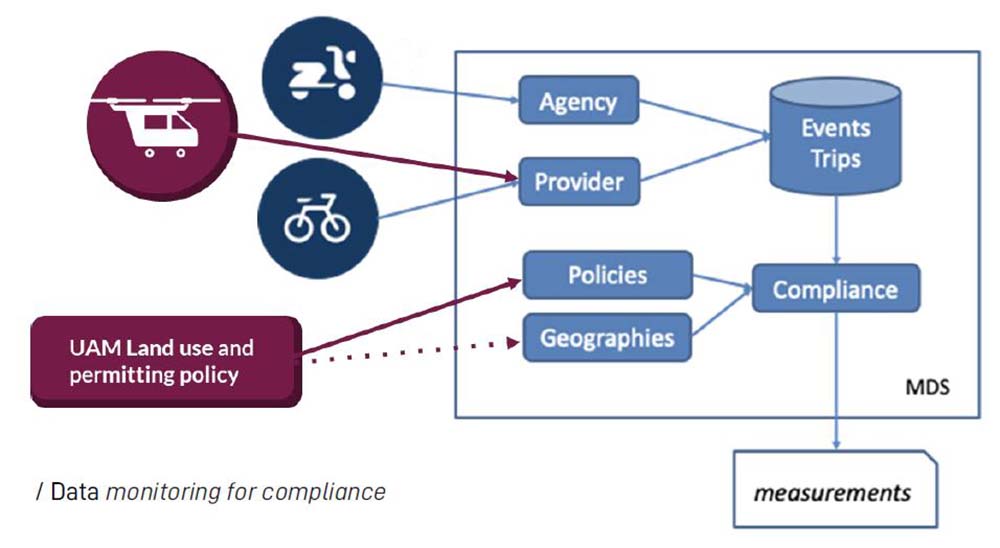
UAM can efficiently integrate with the digital infrastructure to receive information on the state of both air and ground movement within the public right of way. (fire, police, congestion, etc.) Cities and other stakeholders seeking enhanced access to data and information should clearly articulate their need for specific data and should prioritize the protection of individuals’ privacy. Tools like LADOT’s Mobility Data Specification (MDS) can allow operations, compliance monitoring, and help the City make better informed policy updates on an on-going basis.
SUSTAINABILITY
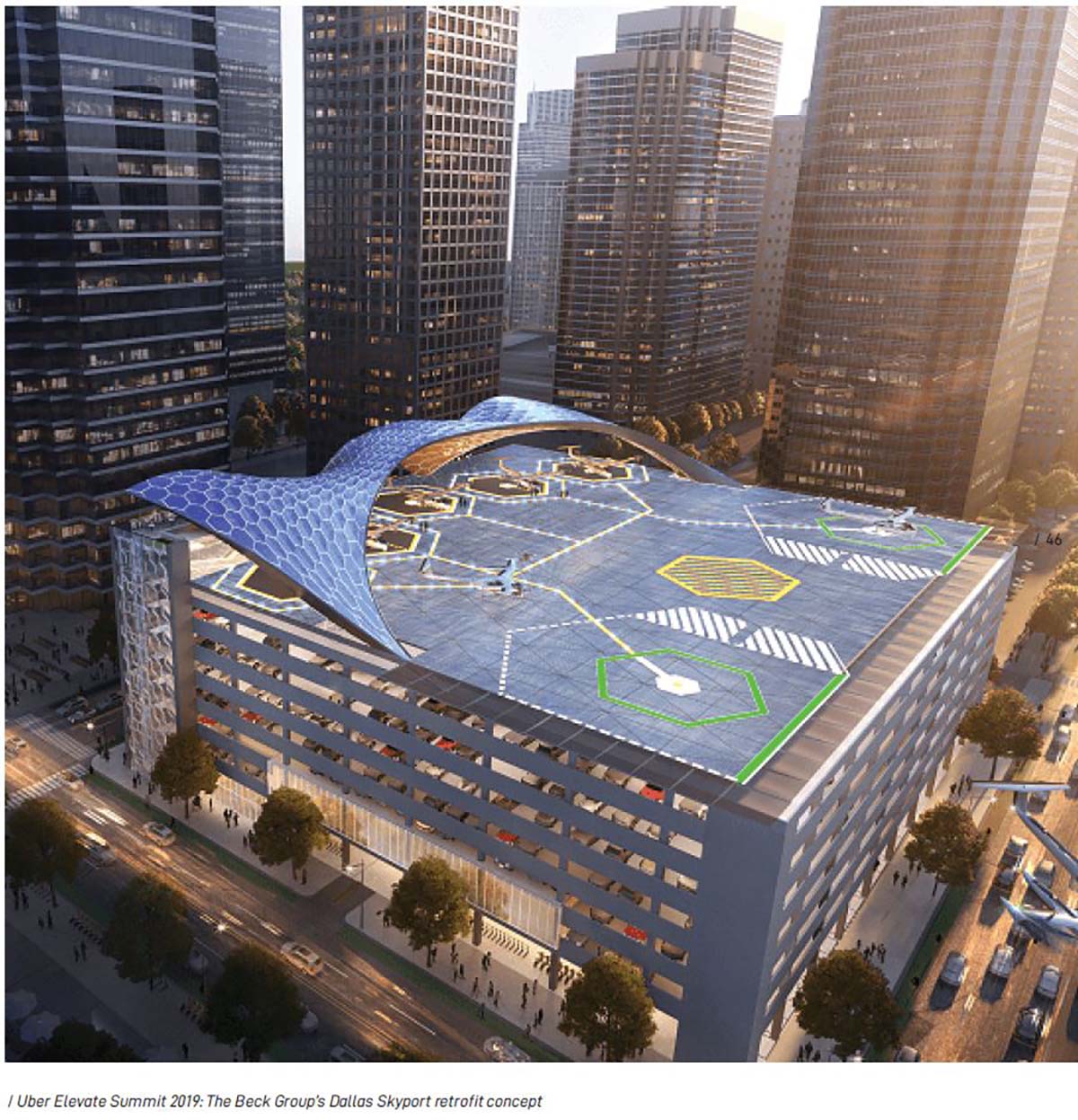
The UAM framework should set clear guidelines for sustainable infrastructure integration. This may include the adaptive reuse of existing infrastructure to include airports, heliports, and even parking garages. UAM should be considered a part of a multimodal solution for connecting travelers with their destinations (See Multimodal Connectivity). This will enable policy makers to align transportation investments across all modes to achieve more sustainable travel behaviors that are aligned with the net-zero commitments outlined by the city’s commitment to climate action. In all modes of transport, all-electric solutions are preferable, which makes all future mobility hubs also energy hubs. Strategically envisioning and planning true multimodal hubs with a UAM component will enable the prioritization of power grid enhancements and other critical investments that facilitate a transition to clean energy.
MULTIMODAL CONNECTIVITY
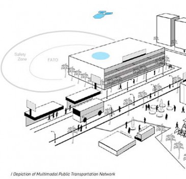
New transit modes should connect with existing forms of transportation and mobility hubs to offer a seamless rider experience and allow for secure, integrated operations. Where possible, UAM should connect to existing, high-quality transportation options (public and/or private), offering seamless travel from the air to destinations in Los Angeles' diverse built environments. City builders, residents, and visitors alike expect urban multimodal transportation networks to provide a safe and user-friendly customer experience.
ECONOMIC GROWTH
Establish LADOT’s role in urban air mobility over the city’s airspace, consistent with the 7 Principles of Urban Sky, specifically local workforce development. Unlike other technological developments being considered for the next decade, UAM is expected to increase jobs on the ground and in the air. One new employment opportunity in commercial aviation operations generates multiple jobs in manufacturing, maintenance, flight approval or other related positions down the line. Job training programs and public/private partnership opportunities including internships for skilled labor positions in aviation and aeronautics can directly target underrepresented communities.
TRANSPORTATION NETWORK ADAPTATION
The UAM framework should set clear guidelines surrounding vertiport implementation policies, permitting, and technology that are future-ready and incorporate sustainable practices. As more types of UAM aircraft go into development targeting air taxi services, a flexible land use policy can be developed that is guided by rigid emissions and noise criteria. Safety regulations incorporated into zoning around vertiports and individual vehicles, can be developed to allow new types of use within them. The permitting of vertiports, UAM aircraft, and their data rich infrastructure provide LADOT, and other City departments, with new controls to help reach environmental, economic, and social goals. Such controls can take full advantage of new technology as UAM aircraft move through FAA certification and production in to specifically improve emissions, noise, safety, and community benefit overall.
Creating a Preferred Future
Looking at the not so distant past demonstrates how yesterday’s technologies and their promise of progress created short term decisions. This has resulted in lasting impact on today’s residents and visitors. The City is taking a holistic approach so that quality of life concerns of today's and tomorrow's communities are at the center of policy decision making.
INDUSTRY AND PROFIT DRIVEN DECISIONS
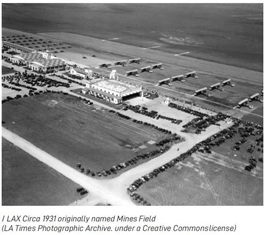
In May of 1927, Charles Lindbergh's famous transatlantic flight helped convince Los Angeles city leaders of the need for a permanent, municipal airport.
Yesterday’s aviation technology provided dynamic new services such as airmail and commercial passenger travel between Los Angeles and other aviation-friendly cities.
Regional airports sprouted around the city with land use prioritized by needed long runway infrastructure and accommodation for private industry maintenance or supply companies.
Today’s aviation innovations promise similar revolutions and bring with it the risk that industry and profit driven decisions alone can potentially create lasting negative impact for future generations.
Similarly, recent app based mobility providers failed to consider potential negative impact on our public spaces. This oversight required significant public resources to create today’s equitable access, safety, and accountability.
The City’s proactive and collaborative approach to UAM allows City stakeholders and private industry to jointly create positive, equitable, and lasting benefits to residents, visitors, and industry alike.
IMPACT FROM LEGACY DECISIONS
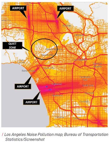
Yesterday’s decisions have unevenly distributed negative impacts from airport and heliport development and operations. Such impacts could have been mitigated had more interdisciplinary policy making been a paramount consideration.
Using technology and lessons learned from the past, UAM Vertiport impact can be more accurately understood, envisioned, and regulated and therefore is much less likely to deliver adverse effects to future generations.
Limitations placed on vehicle specification, time of day access, alternating flight paths, and planned restrictions over sensitive biological areas are a few of the foreseen means to mitigate negative affects for all stakeholders.
MOVING TO EQUITY AND MOBILITY DRIVEN DECISIONS
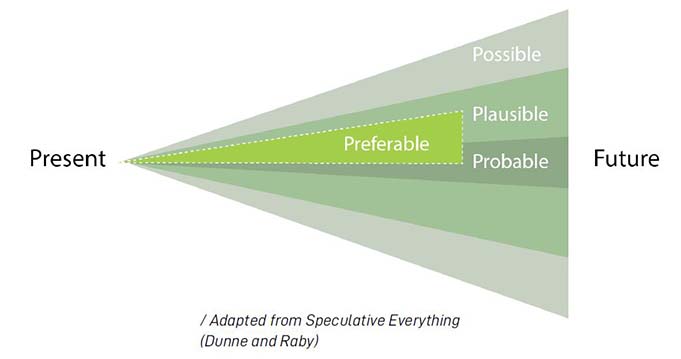
This new form of transportation can deliver many possible future outcomes. Some are plausible and many more probable if UAM technology alone, similar to historic aircraft technology and services, are the primary drive behind policy decision making. On the contrary, the City’s embrace of a proactive and holistic approach helps create Los Angeles’ most preferable future. Equitable deployment and integration of UAM technology into Los Angeles’ transportation network can be achieved by placing the interest of the entire community, for generations to come, at the center of UAM policy decision making.
UNDERSTANDING IMPACT
To maximize public benefit and an equitable inclusionary approach of UAM into Los Angeles’ public transportation system, community engagement is considered an ongoing component of the City’s and LADOT’s advanced planning and forecasting activities.
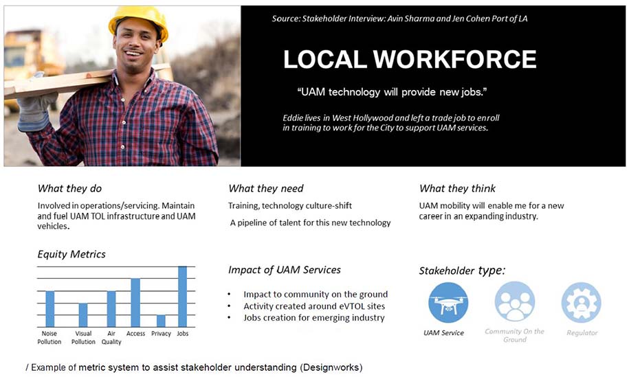
In order to facilitate richer dialogue and to better understand UAM’s future integration opportunities, stakeholder expectations and sensitivities have been translated into Equity Metrics (Noise Pollution, Visual Pollution, Air Quality, Access, Privacy, and Jobs).
Capturing the diverse needs of residents, business owners, developers, operators, city agencies, and federal regulators helps align expectations with how UAM will be equitably incorporated into the existing transportation network and local workforce.
Equity Metrics can help the City collaborate with established local community groups. These groups can play a key role in the City’s community engagement strategy and help gauge where and how residents want vertiports integrated into their communities.
In addition, the creation of stakeholder input groups can provide another high-level community lens in the development of a new UAM policy.
Aligning with Business Improvement District’s (BIDs), Neighborhood Councils, and other advocacy groups through stakeholder input groups can extend community geographic districts and may help identify new opportunities of aligning private investment, advocacy goals, and UAM deployment.
Community engagement keeps all Angelenos’ interests as the primary focal point during the City’s proactive collaboration with State and Federal agencies.
Understanding implications for all stakeholders will improve the outcome of future impact studies conducted by other Departments including but not limited to the Department of City Planning (DCP), and will support more effective dialogue with private industry during LA’s on-going impact analysis of Urban Air Mobility.
STAKEHOLDER UNDERSTANDING
Considering identified needs, aspirations, and concerns from UAM Stakeholder interviews is one part of the City’s on-going community engagement efforts. Positive and negative impacts are compared through a metric system designed to put community interest at the center of near and long term decision making.
In Addition to Los Angeles’ local workforce, the following stakeholders’ expectations and sensitivities have been included:
Community Residents
City Stakeholders
Local Business Owners
Local Vertiport Developers
National Vertiport Developers
Design and Development community
Residential Developers
Local UAM Operators
National UAM Operators
Local Employers
FAA Employees
EXPERIENCING THE FUTURE
In order to carefully consider the impacts of UAM aircraft and their operations, and to best mitigate potentially damaging impacts from policy or regulation, the City has employed experiential tools to address many relevant and hard questions such as:
How do community stakeholders experience the noise generated by future UAM take-offs, landings and flyovers today?
Do UAM flights layer into the background noise of Los Angeles? How do we evaluate it?
How can the importance of UAM impact be communicated to policy makers that must eventually result in successful integration?
Can trust between experts and a community be established?
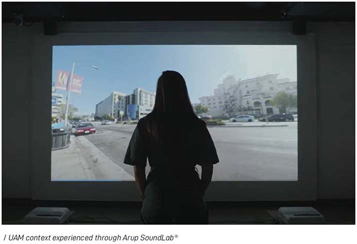
State-of-the-art calibrated immersive simulations place community and city stakeholders on the ground of hypothetical UAM sites. Varying context, such as vehicle type and site characteristics allow participants to experience visual and auditory aspects of UAM aircraft take off, landing, and flyby operations. Similar to automobiles, UAM aircraft have varying configurations and styles that are associated with specific performance. Calibrated aural profiles of traditional helicopters are used as a baseline to compare and contrast against large and small UAM aircraft to provide accurate context for viewers of the simulations.
Comparing different scenarios helps understand what is acceptable to a surrounding community. These simulations are built on criteria within a regulatory context to help inform the policies and data parameters needed to regulate UAM far ahead of the deployed technology.
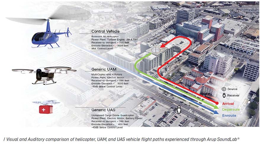
Noise contours for typical aircraft need to be established on a site by site basis. The simulation of such contours helps evaluate the height (elevation) of the Touchdown and Lift Off (TLOF) surface, approach/departure fight paths, expected aircraft types and frequencies, and visual impact of operation.
The Community Noise Equivalent Level (CNEL) is an average made up of numerous single noise events. Including CNEL provides the context needed help define aircraft fleet mix, define flight paths or corridors, and determine limits to prevent possible negative aspects from UAM.
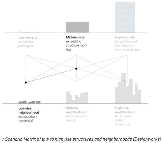
These robust simulation tools are helping the City establish threshold levels of impact acceptable to a community, relative to specific land uses and densities, while considering existing public transportation and the surrounding context (urban, suburban, open space, etc.).
Developing regulations and solutions for aircraft noise requires a multifaceted approach. The City’s use of new simulation technology helps inform policy makers, and further ensures the community’s interests and the preservation of the natural environment are at the forefront of UAM policy decision making.
PHASED APPROACH
The City of Los Angeles’ early consideration of UAM and its implications helps implement a safe, equitable and sustainable new form of transportation.
An iterative implementation strategy over the next two decades allows stakeholders to evaluate initial UAM trials and partial deployment. This phased approach best informs the construction and scaling of new infrastructure, and helps the community benefit from equitable access to multimodal transportation and its land use.
LA’s commitment to UAM has been bolstered by the Mayor’s announcement of seating a new UAM Fellow with a keen focus on community engagement, continuing to plan for equitable access, and to ultimately translate UAM implementation into sustained Workforce Development.
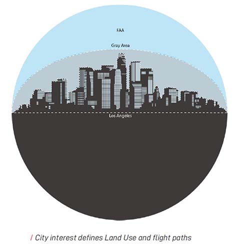
OVERLAPPING BOUNDARIES
As UAM becomes ubiquitous within the fabric of LA’s public transportation and existing land use, regulations limited to airports and the FAA controlled airspace no longer satisfy all needs of Los Angeles. City property, land use, and multimodal integration require the creation of a uniform regulatory framework that works well for the FAA, industry, local government, and the community alike.
As UAM technology results in services that require new role definition for regulators and operators, Los Angeles’ proactive approach is providing assurance that our collective future is our most preferred future.
Purpose and Organization of Document
The priorities stated above, coupled with the aims of UAM, will be the basis of a framework for a UAM policy that considers both land use and permitting. It is LADOT’s aspiration that this framework document could serve as a model to help other cities establish their own policies around UAM. The document is organized in four sections:
- ROLES AND RESPONSIBILITIES
What is the City’s role in UAM, and how does it fit into a larger aviation picture that includes state and federal agencies such as the CTC, Caltrans, the FAA, or NASA?
- CONSIDERATIONS FOR LAND USE POLICY
A guide for developing policies that establish the influence areas and safety zones for vertiports, as well as the associated land use and environmental regulations that should be considered in zoning regulations.
- VISION FOR KEY AREAS OF INTEREST
How do the City’s strategic pillars of equity, health and safety, sustainability, economic growth, deidentified data, and multimodal connectivity translate into the UAM policy framework?
- FUTURE POLICY AND IMPLEMENTATION OPTIONS
A summary of permitting considerations for vertiport developers, UAM operators, UAM vehicles, and UAM service booking agencies.

1.1 INTRODUCTION
As with any emerging transportation technology, there will be an evolutionary process whereby UAM vehicle technology will be developed and advanced. Vehicle propulsion is expected to evolve from hydrocarbon power to hybrid or fully electric power. Takeoff and landing characteristics are expected to evolve from traditional rotary to vertical takeoff and landing (“VTOL”, or “eVTOL” when electric powered, including transitional from rotary for lift to winged flight). Piloting is expected to evolve from traditional “piloted” with pilot in cockpit, to “Unpiloted”: initially remotely piloted, and eventually autonomous. New types of UAM aircraft will have a very different flight trajectory and noise profile than today’s helicopters. As such, the proposed framework incorporates the need for evolutionary flexibility, by considering three phases of UAM air operations:
- INITIAL:
Operations are conceived considering current rules, regulations, and local agreements, initially aligning with current regulations around helicopters.
- DEVELOPING:
An increase in operations will continue the incremental changes to the existing regulatory framework and procedures, including the establishment of a Provider of Services for UAM (PSU).
- ESTABLISHED OPERATION:
Operations likely to evolve along the lines of key indicators such as structure, regulations, and automation levels. Additional regulations will be jointly identified and established by City, State, and Federal authorities.

During the initial phases of operations, LADOT and its partners should gather data on various characteristics of UAM flights specific to the final approach and takeoff to identify where disparities between UAM and typical helicopter operations exist in the areas of noise and safety.
These data points will serve to influence modifications to vertiport design and community planning standards which could be implemented in a “developing” UAM market in subsequent years.
Further refinement of these characteristics and technology developments will help guide policy as the UAM market enters an “established operation” or more mature stage.
1.2 ROLES AND RESPONSIBILITIES OF THE CITY
The role of the City is to ensure that Los Angeles has a safe, efficient, and modern transportation system that improves the quality of life for its communities and assures equitable and sustainable access to mobility and connectivity choices for all residents, businesses, and visitors.
The City is taking a comprehensive approach to the transportation network through consideration of how transportation needs impact the community's priorities, from public safety to economic and community development.
Given the unique nature of the operations of UAM aircraft, a major component of the City’s strategy will be the planning, regulation, and enforcement of an orderly development of a vertiport network, and how the vertiport network will be integrated into the City’s overall transportation network.
The building, operation, and maintenance of individual vertiports are anticipated to be supported through ever evolving forms of Private Public Partnerships with a focus on benefitting the local workforce and stakeholders.
The City’s primary goal of equitable and safe integration of UAM technology will inform all phases and therefore will best align all private and public interests along side policy objectives.
RESPONSIBILITIES SPLIT BETWEEN LADOT, OTHER CITY DEPARTMENTS, AND REGULATORY BODIES FOR THE IMPLEMENTATION OF UAM COULD INCLUDE:
1.
Mapping expressed public needs and equity goals to city plans, policies, and permitting.
2.
Integrating UAM services into existing and future transportation policies and plans.
3.
Integrating UAM infrastructure into existing and future land use policies and plans.
4.
Interfacing with NASA and the FAA to ensure aircraft and airspace safety.
5.
Interfacing with various levels of government to ensure UAM operation security and safety for the community and environment.
6.
Permitting operators or Providers of Services for UAM (PSUs) and setting local policies. (e.g. hours of operation, vertiport access, trip priorities, and trip or operator fees).
7.
Participating in multi-directional data exchange for key areas such as real-time route shifting for planned or emergency events, increasing access to vertiports, or monitoring policy compliance.
8.
Working with other municipalities and the county to ensure UAM policy consistency.
9.
Working with transit and public transportation operators to operate UAM services independently or in coordination with existing transit services.

1.2.1 INTERAGENCY COORDINATION
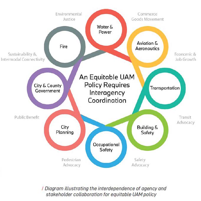
In addition to the main actors of the UAM ecosystem, successfully implementing the UAM program will require coordination and cooperation between regulators and agencies at every level from national to local to define and resolve any conflicts that may arise within the essential roles and responsibilities of the UAM system. Even though civil aviation authorities are accustomed to dealing with all airspace issues, the integration of UAM will require city and regional stakeholders to take an active role in shaping some aspects of UAM policy development. These ecosystem stakeholders must work together to integrate UAM operations strategically and efficiently within the context of broader smart city planning efforts. They should also pay close attention to the wants and needs of the communities in which UAM will be implemented, working to get ahead of potential issues such noise and visual pollution, while also identifying opportunities for UAM to help the community achieve its goals. Working group with relevant stakeholders should convene regularly to ensure compliance with legal and safety standards. These working groups are a good opportunity to have stakeholders share knowledge, collaborate to solve any potential issues, identify operational improvements, and plan for future changes. The following agencies have been identified as potential stakeholders:
- Federal Aviation Administration (FAA)
- National Aeronautics and Space Administration (NASA)
- Los Angeles Department of City Planning (DCP)
- Los Angeles Department of Transportation (LADOT)
- Los Angeles Fire Department (LAFD)
- Los Angeles Department of Water and Power (LADWP)
- Los Angeles Department of Building and Safety (LADBS)
- City / County of Los Angeles
- CalTrans Division of Aeronautics
- Airport Authorities (e.g. LAWA, SMO, BGPAA, LGB, etc.)
- California Division of Occupational Safety and Health (CalOSHA)
- National Institute for Occupational Safety and Health (NIOSH)
- Port of LA
- SoCal Gas
1.2.2 KEY STAKEHOLDERS
In parallel to convening relevant stakeholder groups of national and local regulators and agencies, the City should create a platform for participation of relevant community groups. The creation of an Advocacy Advisory Committee (AAC) will provide a high-level community lens in the development of a new UAM policy. The intent is that the AAC will document the wants and needs of the communities in which UAM will be implemented.
Sessions of the AAC should aim on getting ahead of potential issues such as noise and visual pollution, while also identifying opportunities for UAM to help the community achieve its transportation and quality of life goals. The AAC can be one conduit by which local voices are heard and accounted for. Ideally, AAC participants should come from local community groups with varying special interests.
The AAC should align with the City of Los Angeles Transportation Commissioners specifically for UAM related topics and interface with other stakeholder advisory groups that the City partners with for a comprehensive dialogue.
The following types of interest groups should be considered:
- Environmental Justice
- Transit Advocacy
- Pedestrian Advocacy
- Safety Advocacy
- Civil Rights
- Economic
- LA Community Leaders
1.3 VISION FOR KEY AREAS OF INTEREST
1.
EQUITY
As key priority areas, equity should be considered critical indicators of success for UAM in Los Angeles. The following equity considerations should be applied to all planning involved with deciding how and where the UAM ecosystem will operate.
COMMUNITY ENGAGEMENT
In addition to the operational stakeholders, interagency coordination, and the AAC, targeted community engagement with local stakeholders should be the primary focal point. This way DCP and LADOT can gauge where and how residents want vertiports integrated into their communities. Community engagement will be considered at every stage of the process, from framework development to approval of vertiport sites, frequency of operation, and multimodal integration. Engaging directly with established local community and advocacy groups is a pillar of the City’s community engagement strategy.
ENVIRONMENTAL NOISE
DCP and LADOT should carefully consider the environmental noise impacts of UAM aircraft types and their operations, and facilitate mitigation of potentially damaging impacts through policies and regulations.
The introduction of UAM, with multiple new vehicle types and flight patterns, will require updates to noise abatement policies, which if done effectively, could improve the public’s acceptance of UAM within the Los Angeles soundscape.
VERTIPORT ACCESSIBILITY
Accessibility should consider all users including people with disabilities and seniors, and underserved communities, particularly communities of color. The network of vertiport sites should ultimately be equitably distributed throughout the City and connect to existing transportation networks. In addition to including them in all areas where they would be welcome (based on community stakeholder input), the City and LADOT should ensure that they are planned with equitable access by all users in mind. Incentivizing placement of vertiports in underserved communities may be an option to ensure equitable access, but such a policy would need to be based on clear community desire, connectivity to existing transportation networks, and considerations for negative impacts to surrounding community.
CORRIDOR SATURATION & FLIGHT PRIORITY
While determining the configuration of UAM corridors, DCP and LADOT may want to consider paths that minimize flights over residential areas; and largely constrain paths to noise generating transportation paths – freeways, rail lines, and main arterials – as the established and publicly charted helicopter routes do today. Furthermore, varying noise regulations should be considered for differing types of aircraft used for emergency services, passenger movement and goods movement. While these paths will not fully mitigate environmental noise to surrounding properties as there is a direct line of sight to the UAM flight path, the flight paths would align with other noise producing pathways that have some impact on the surrounding land-use. First responder vehicles shall take priority similar to terrestrial transportation.
ECONOMIC DEVELOPMENT
The integration of UAM in the urban fabric has the potential to benefit a community at every level, from local businesses to citizens in search of employment opportunities, both directly and indirectly. Local and regional stakeholders must take active measures to ensure that these benefits are realized to their full potential however. For example, UAM can help cities and regions attract new forms of investment, but stakeholders must make strategic choices in the process of infrastructure development to ensure that investment is funneled to the areas that need it most. Additionally, job training programs to attract, encourage, and invest in communities of color that are underrepresented in aviation and aeronautical skilled positions will also bring an equity aspect into the economic development that the UAM opportunity brings Los Angeles. As such, cities and regions should work closely with the business community to ensure that UAM is thoughtfully implemented and positioned to become a long-lasting component in local and regional transportation systems.
PAYMENT SYSTEMS AND FARES
While fare pricing may depend on UAM operators, DCP and LADOT as governing agencies might consider implementing policies or incentives for operators to provide lower fares and more accessible payment options to low-income users.
FLIGHT PRIORITIZATION
In the scenario where there are a limited number of UAM Corridors and the UAM network has not been developed sufficiently to allow for additional capacity, there will likely be cases where demand for UAM flights exceeds capacity, known as system saturation. When this is the case, a system of prioritization will be required. Prioritization criteria may include, but would not be limited to, the following types of flights (not necessarily in priority order):
- Distress: Serious and/or imminent danger, requiring immediate assistance.
- Urgency: Condition requiring immediate attention to maintain safety (emergency, etc.)
- Direction Finding: Situation where piloted or unpiloted navigation requires assistance
- Flight Safety: Condition concerning the safety of an aircraft or passenger (mechanical, medical, fire, etc.)
- Meteorological: Environmental changes or weather related situation affecting safety
- Flight Regularity: Consistency of operations to prevent delays or passenger complaints
- Higher Occupancy Aircraft: Greater payload requiring specific operational needs
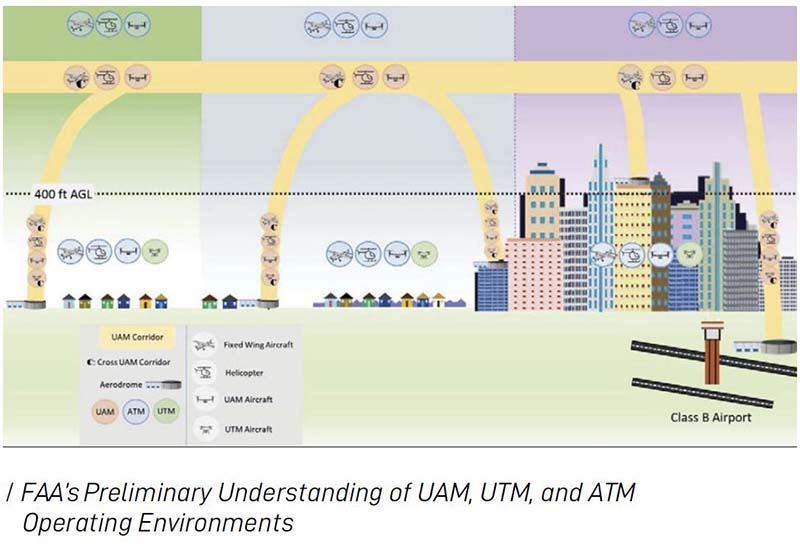
Looking ahead to a future environment where the UAM system has been implemented for a significant amount of operational time, and continues to mature and expand, the anticipated high volume of flights (e.g. peak hour demand) in a thriving system will require many designated flight corridors to accommodate such demand (termed “UAM Corridors” in the FAA UAM ConOps document).
2.
SUSTAINABILITY
The UAM framework should set clear guidelines surrounding vertiport implementation policies, permitting, and technology that protect the environment through adaptability to the evolving industry. As UAM aircraft promise quieter and greater efficiency over time, a flexible UAM policy should establish clear criteria to incentivize operators and riders to choose zero emissions vehicles that help to decarbonize the City’s transportation network.
EMISSIONS
While the City and LADOT does not have jurisdiction to directly regulate the emissions of UAM aircraft given state and federal regulations in place, there are several strategies the City could use to effectively regulate the level of emissions that the public is exposed to from UAM aircraft. Such strategies, as described in the permitting framework section of this document, include:
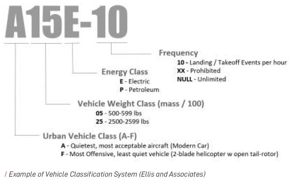
- Regulating the types of vehicles that can land on city-permitted vertiports (incorporating a Vehicle Classification System)
- Limiting fleet size according to fuel type: all fossil-fuel, hybrid, and zero emission
- Limiting the provision of fossil-fuel refueling capabilities at city-permitted vertiports (through fire code or other ordinance limiting the presence of fossil fuel storage on-site)
- Incentivizing electric and renewable electric recharging capabilities and non fossil fuel vehicles at city-permitted vertiports
INCENTIVIZING ZERO EMMISON TRIPS
UAM policy should further incentivize the use of zero emission transit and the use of zero emissions multi-modal systems (transit, walk, cycle). Such incentives that align with the Mayor’s Green New Deal and Executive Directive 25 will help UAM replace existing forms of transit that aren’t zero emissions.
LEVERAGING DATA AND TECHNOLOGY
The existing National airspace is managed through a network of radar stations and manned air traffic control centers that monitor and manage the position of aircraft in the skies. This system will be even more important in order to successfully separate aircraft in a highly concentrated and dynamic environment of aircraft, micro-climates, and various obscurations. Los Angeles plans on integrating with these systems to both provide information on the availability of vehicle charging infrastructure, ground-based incidents, and to communicate digitally acceptable use for vertiport infrastructure. Data from these systems can be leveraged to inform the need for future investments in vertiport infrastructure and measure socio-economic, sustainability, and environmental outcomes.
In conjunction with collaborations with NASA and other members of the Open Mobility Foundation, LADOT’s digital policy platform will be enhanced to accommodate UAM use cases and data structures while also preserving privacy outcomes according to the principles developed by the department in 2018-2020 to protect user privacy for micromobilty.
INTEGRATION INTO THE TRANSPORTATION NETWORK
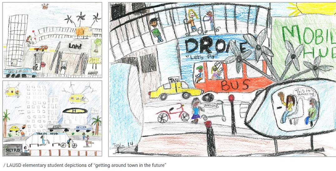
The promise of UAM aligns with the City’s goal of harnessing future transportation technology to optimize sustainable mobility across all modes of transportation.
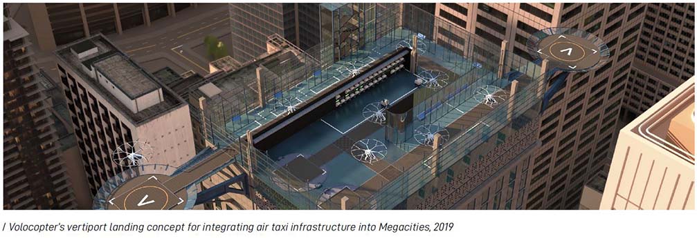
Vertiports will be one aspect of the multimodal vision that LADOT has for Los Angeles. Trips made on UAM will serve passengers across many distances in a quick manner, but we must recognize that many trips will not begin or end in the immediate vicinity of the vertiport. To ensure UAM is fully integrated into the safe, healthy, livable and sustainable transportation network of the future, vertiports will need to be well integrated with other modes to ensure the first/last mile connections provide options for all users and trip types.
To achieve this, a focus on ground transportation integration should be a requirement for vertiports. Siting vertiports along existing transit routes, such as Metro Rail and Bus lines, will provide equitable access to these facilities. Additionally, an emphasis on shared mobility at the vertiport should be made to further emissions reduction. LADOT’s mobility hubs may be expanded to these sites to provide BlueLA carshare, Metro Bikeshare, and other private shared mobility services including scooters and dockless bikeshare. Incentives for UAM could further discourage Single Occupancy Vehicle users/connectors.
Through this multimodal integration, UAM will have the opportunity to become an accessible and integral part of LA’s multimodal and sustainable transportation network.
3.
HEALTH AND SAFETY
Safety should include the protection of people, animals, and property on the ground and in the air from vertiport-related hazards.
Categories of safety include safety at the vertiport, safety around the vertiport (including height restriction areas and vertiport safety areas), aircraft safety, and personal safety for passengers and staff.
SAFETY AT THE VERTIPORT
It is important to issue a baseline set of physical security requirements for vertiport operators as typically seen at airports. Such an approach should include multi-layered protection with local physical security risks being assessed as part of the permitting and regulatory review on a case-by-case basis.
(See Section 3.2.1 for details).
SAFETY AROUND THE VERTIPORT
Vertiport safety regulations can be integrated into zoning to minimize the number of people exposed to potential UAM aircraft accidents in the vicinity of the vertiport by considering density and use limitations within these zones
SAFETY OF SURROUNDING BIOLOGY
In addition to specifying safety requirements for persons and property, the UAM policy will include means of protecting the surrounding wildlife and natural environment..
(See Section 2.3.1 for details).
AIRCRAFT SAFETY
Since its inception, the Federal Aviation Administration has made its mission to establish safe practices for designing, building, and operating aircraft. In 2017 it achieved its goal of zero commercial passenger fatalities. Operating in low-level airspace increases the importance of existing and new regulations that address safety systems in UAM aircraft designs and operations. Cities like Los Angeles will complement shared safety outcomes with Federal Regulators through thoughtful vertiport placement, assessment of flight corridors, and public provisioning for weather sensor networks.
PERSONAL SAFETY OF PASSENGERS AND STAFF
Safety at vertiports will be required to protect passengers, staff, aircraft, and vertiport property from accidental or malicious harm, crime, terrorism, and other threats. Such an approach should include multi-layered protection, combining restrictive user policies, security monitoring, and consideration of how to protect those directly under UAM flight paths.

2.1 PURPOSE
Consideration for establishing approaches for regulating land use around vertiports designed to help the City promote a safe, healthy, livable, and sustainable transportation network of the future through policy and regulation.
Some factors to consider for establishing possible land use policy around UAM may include the following::
- Review existing land use plan and zoning codes
- Assess how equity goals are being achieved
- Consider vertiport safety and influence zones
- Consider height and land use impacts within each zone
- Consider criteria for vertiport level of utilization (volume) and time of day (curfew) restrictions
- Identify transportation network implications and integration into a multimodal network for criteria requirements
- Establish criteria for general vertiport location approval process
2.2 BACKGROUND: CURRENT HELIPORT DESIGN
Per the “Urban Air Mobility Concept of Operations v1.0” issued on June 26, 2020 by the FAA, initial vertiport design criteria can coincide and incorporate current heliport and helipad design criteria, until sufficient flight performance data for UAM and VTOL aircraft can justify refinements to these standards and/or creation of new standards for UAM aircraft. Issues related to community planning (primarily noise, safety, and airspace clearance) are covered in the FAA Advisory Circular (AC) and are expanded in more detail in the California Airport Land Use Planning Handbook.
The FAA is developing interim guidance for vertiports based on UAM performance compared to traditional helicopters. Differences or gaps will be filled by performance standards and vehicle performance categorization.
DCP would lead the effort on creating the policies and codifying a regulatory permitting process with the input and collaboration of LADOT's technical expertise.
2.3 DEVELOPING A LAND USE POLICY
2.3.1
CEQA
CONSIDERATIONS
The California Environmental Quality Act Guidelines (CEQA) requires that new development must be environmentally assessed for any impacts that may result from new development. A key consideration for the City will be to decide how to incorporate UAM vertiport siting into the City’s land use and zoning codes. Environmental assessment will be done for all aspects of policy development and any implementation considerations
2.3.2
REVIEW EXISTING LAND USE
PLAN AND ZONING CODES
When considering where vertiports could or should be located, many factors need to be considered. These factors can be broadly categorized into connectivity – how well the vertiport is connected to both the urban air system as well as ground transportation systems; land use compatibility – whether the surrounding land uses can generate or benefit from demand for urban air travel; and community impact – the effects of both positive and negative externalities from the vertiport.
MULTIMODAL CONNECTIVITY
Developing and Establishing UAM Corridors: Vertiport locations on or near established flight paths should be prioritized to minimize overflight of non-designated flight paths. As UAM evolves, new UAM corridors will need to be identified and established. LADOT and DCP should work with the FAA and other partners to ensure that these corridors do not negatively impact or favor one community over another, while still creating a safe and efficient network for urban air travel. Community engagement will be key to developing equitable and accessible corridors.
Connections with Ground Transportation: Vertiport locations should be well-connected with existing and future ground transportation, medical centers, and fulfillment locations. Locations within close proximity to high capacity transit systems, such as Metro Rail and Bus, Metrolink, and Amtrak, should be prioritized.
LAND USE COMPATIBILITY
Current and Potential Land Uses: Vertiport locations should consider what types of land uses may support UAM demand, such as major retail centers, stadiums and arenas, major tourist attractions, higher education campuses, offices, and major transportation facilities. Certain types of land use may be more incompatible with vertiports, such as K-12 schools, and other sensitive uses.
Zoning: DCP can consider which current zoning or new zoning may be needed to allow for vertiport development.
COMMUNITY IMPACT
Socioeconomic and Demographic Characteristics: The distribution of vertiports in the City should carefully consider balancing both access and exposure to UAM operations. Closely linked to UAM corridors above, LADOT should work with DCP to ensure that vertiport locations do not negatively impact or favor one community over another. Strong community engagement will be an on-going necessity while considering where to allow future vertiport development.
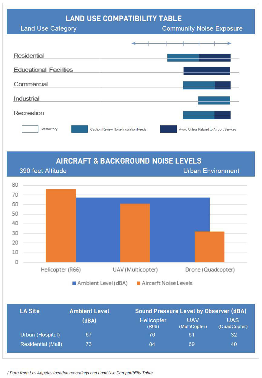
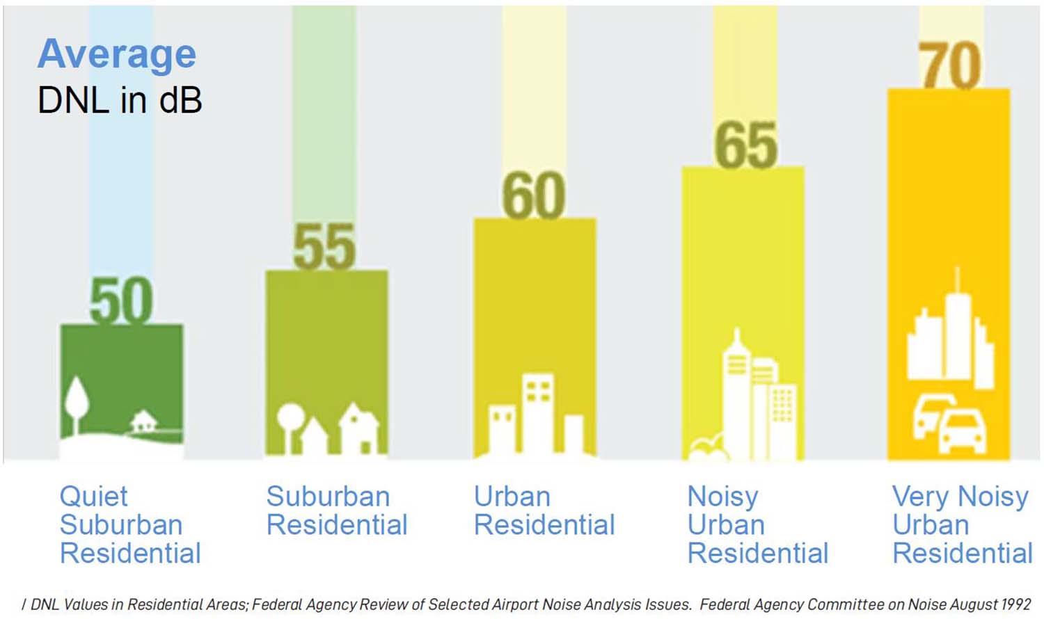
Noise: Certain land uses that may be sensitive to noise should be carefully considered. Acceptable community noise levels for UAM aircraft are still unknown as there are limited studies and manufacturer data available at this time. However, we anticipate future policy will reflect todays in that acceptable noise levels will vary for different land uses, as shown in the Land Use Compatibility Table above, from the Los Angeles County Airport Land Use Plan (2004). The Table to the right shows sound level comparisons by vehicle type compared to ambient noise at hypothetical vertiport locations.
2.3.3
CONSIDERATIONS FOR DEVELOPING GENERAL
VERTIPORT LOCATION APPROVAL PROCESS
While specific location approval will need to be more rigorous and take into account the specific vertiport design for the site, as discussed in the following sections, the City can take a first step by considering generalized areas where a potential vertiport might be located. The considerations discussed in the previous section should provide a starting point for the approval process of general vertiport locations, and should align with LADOT’s Strategic Work:
- Equity
- Health and Safety
- Sustainability
- Economic Growth
- Deidentified Data
- Multimodal Connectivity
2.3.4
CONSIDERATIONS FOR POSSIBLE VERTIPORT SAFETY
AND INFLUENCE ZONES
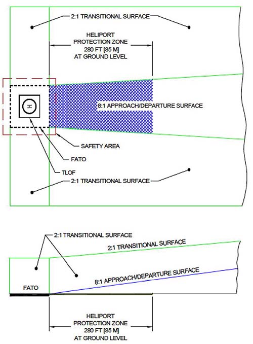
Initial considerations for the framework is to consider vertiport safety zones to protect the safety and noise impacts in the vicinity of the vertiport by imposing land use limitations. The safety zones to the dimensions of the “design aircraft”, which is the largest type of aircraft the vertiport is designed to accommodate. Vertiport safety zones in the future will likely differ from heliport safety zones with appropriate modifications for new types of UAM aircraft.
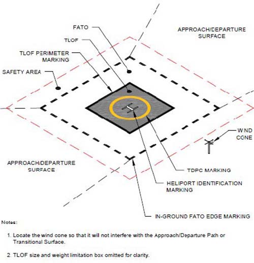
The graphics below show the various zones around a heliport that could be used in initial stages of UAM operations. These zones will evolve once more is known about UAM vehicle flight paths and noise contours.
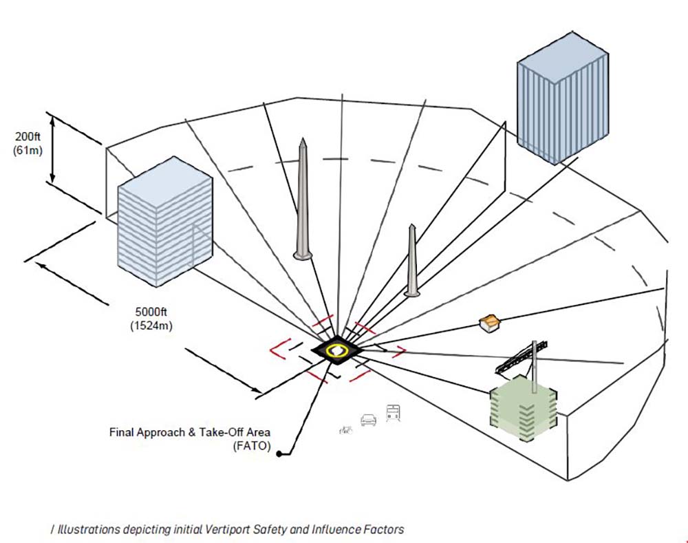
When developing the extents of a Vertiport Influence Area (VIA), LADOT could reference guidelines for heliports and Heliport Influence Areas (HIA) provided by the California Airport Land Use Planning Handbook and the FAA Advisory Circular 150/5390-2C. Three key factors should be considered:
1. VERTIPORT SAFETY AREA AND PROTECTION ZONES
As more data becomes available for typical UAM operations, DCP, LADOT and its partners could work with the FAA to re-evaluate the risk level that is actually present within zones and determine if additional land uses and densities may be permitted within them.
2. NOISE CONTOURS FOR TYPICAL AIRCRAFT ON FINAL APPROACH AND TAKE OFF
Noise contours for typical aircraft need to be established on a site by site basis and may follow the guidance in the California Airport Land Use Planning Handbook or the FAA’s integrated Noise Model.
DCP and LADOT can reference the guidance provided in the Los Angeles County Airport Land Use Plan (2004) when measuring noise levels near a vertiport:
3. AIRSPACE CLEARANCE SURFACES
While national airspace is regulated by the FAA, it is the local government’s responsibility to ensure that the airspace surrounding airports (including heliports and future vertiports) and the designated air routes into and out of an airport are maintained.
As more data becomes available for typical UAM operations, DCP and LADOT (and its partners) may work with the FAA to re-evaluate the typical configurations of these surfaces to determine if revisions could be made for vertiports serving only UAM aircraft types.
2.3.5
EXISTING LAND USE REGULATION CONSIDERATIONS
The City can consider all of the various factors that need to be part of the land use, environmental, and community visions for Angelenos to enable a safe, equitable, and sustainable integration of UAM.
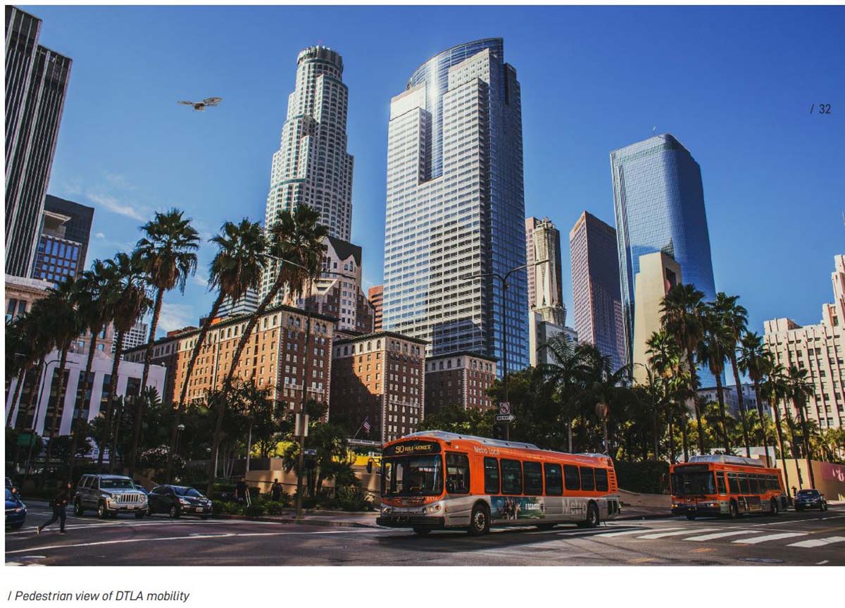
2.3.5.1
HEIGHT LIMIT
CONSIDERATIONS
Height limitations in the vicinity of a vertiport are required to protect the public safety, health, and welfare by ensuring that UAM aircraft can safely navigate the airspace around the vertiport in the critical takeoff and final approach phases of flight. This protects both those in the UAM aircraft and those on the surface who could be injured in the event of an accident. In addition, height limitations are required to protect the operational capability of vertiports to accommodate a variety of UAM aircraft types in a variety of weather conditions.
As mentioned earlier, while national airspace is regulated by the FAA, it is the local government’s responsibility to ensure that the airspace surrounding a vertiport and the designated air routes into and out of a vertiport are clear of vertical encroachment via zoning and individual building height permits.
It is conceivable that there may be cases where vertiport height limits contradict allowable zoning. The policy framework should address community need for balance between airspace versus focusing on development rights when such cases arise.
2.3.5.2
VERTIPORT LAND USE
COMPATIBILITY
When considering where new vertiports should be located, the City can reference existing resources such as the California Airport Land Use Planning Handbook and The California State Aeronautics Act requiring all public-use heliport’s need to obtain a Heliport Permit.
If a public-use heliport is considered a public airport it then requires an Airport Land Use Compatibility Plan (ALUCP) developed by a local Airport Land Use Commission (ALUC).The City could consider similar provisions for vertiport permitting and development of a land use compatibility plan for vertiports intended to be used by eVTOL aircrafts and operators.
NOISE AND OVERFLIGHT
In many ways, 2021 is much like 1958 where the existential question is if the public will accept aerial travel as safe and sustainable transportation. Low noise technologies can help earn public acceptance of UAM as a net benefit to society.
The City has invested in research to further understand how these new types of aircraft are experienced by those at vertiports and those living, working, and playing near them. The findings reinforce the importance noise has on public acceptance and supports to a tiered regulatory framework based on a new Vehicle Classification System (VCS). Operators using low-noise aircraft could be rewarded with take off and landings in more places than high noise aircraft use. Such an approach could simultaneously help the City garner public support for UAM operations and also manage those services through integration policies served by the City’s Digital Policy Platform.
While the noisiest part of flight is typically experienced during takeoff and landing, overflight of sensitive areas is also a concern and an important factor in public acceptance. Los Angeles can work closely with the FAA and aircraft operators to define flight corridors that maximize safety and minimize any negative impacts on Angelenos.
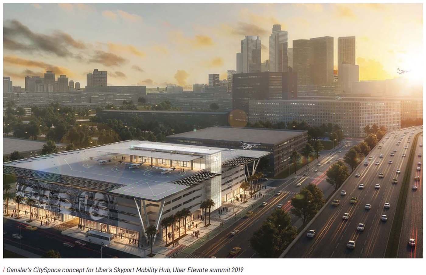
SAFETY AND AIRSPACE PROTECTION
- Establish the extent to which aircraft safety concerns on final approach, take-off and landing may affect surrounding land uses (a Vertiport Influence Area, or VIA).
- Establish acceptable levels of risk related to specific land uses and densities, considering the surrounding urban form and context (urban, suburban, open space, etc.)
The four key topics addressed in an ALUCP are:
1
Noise:
Minimize the number of people exposed to frequent and/or high levels of aircraft noise capable of disrupting noise-sensitive activities.
2
Overflight:
Notify people near airports of the presence of overflights to minimize or avoid annoyance associated with these conditions.
3
Safety:
Minimize the risks associated with potential aircraft accidents by providing for the safety of people and property on the ground and enhancing the chances of survival of the occupants of aircraft involved in an accident.
4
Airspace Protection:
Avoid the development of land use conditions which, by posing hazards to flight, can increase the risk of an accident occurring.
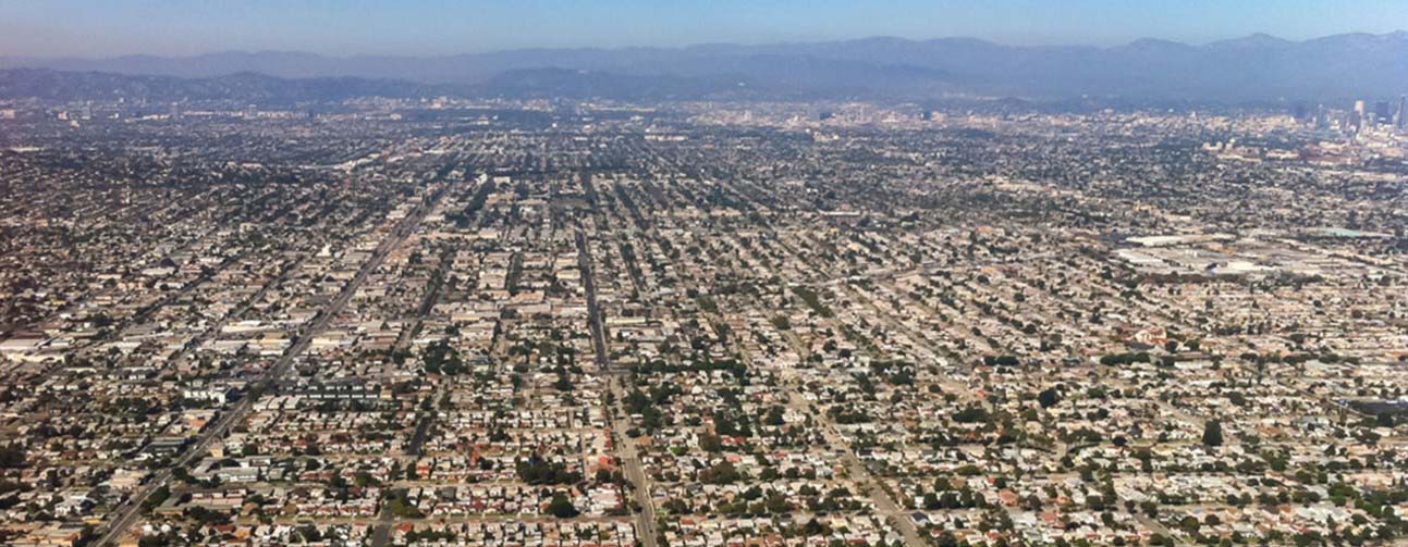
2.3.6
POSSIBLE COMPATIBLE LAND USES
The City should examine what existing land uses are complementary to each other as well as examine what land uses are not compatible or may cause negative or unwanted impacts. Generally, sensitive uses are prioritized in order to identify and avoid locating incompatible land uses near sensitive uses.
As sensitive uses include a broad range of uses such as schools or single family residences, the City can do a full land use analysis to evaluate the opportunities that best identify possible vertiport locations.
VERTIPORT PROTECTION ZONE
One option for helping to develop opportunities with land use compatibility is to create Vertiport Protection Zones.
These zones can be developed to both protect sensitive uses from negative impacts and to co-locate compatible land uses near each other. The creation of these zones can include noise impact considerations to ensure that land uses do not create ambient noise levels resulting in negative impacts to the surrounding areas.
2.3.7
CONSIDERATIONS FOR ESTABLISHING VERTIPORT UTILIZATION AND OPERATIONS
The City’s responsibility is to regulate the utilization of vertiports in order to limit noise nuisance and mitigate safety concerns for the surrounding community. A number of factors can contribute to the functional capacity of a vertiport.
These factors can include the following: Capacity of the adjacent UAM air corridor, the number of landing pads and aircraft parking spaces available, the passenger processing capacity of the facility (including ground-level passenger pick-up/drop-off....landing pad), other local ground transportation, number of daily operations, hours of daily operations, and trip type/purpose (emergency trips for medical services, goods movement, passenger movement, etc.).
|
|
Note:
Studies have shown that low community acceptance of transportation increases in areas having low background noise. National Parks Service has partnered with certain entities to conduct long-term background noise level studies in Los Angeles and other cities, and further study is necessary to quantify this impact on the public.
|
|
The City’s commitment to understanding UAM noise relative to community benefit and its impact on the surrounding built and natural environment can help inform local, state, and federal agencies.
2.3.8
INTEGRATING VERTIPORTS INTO A
MULTIMODAL NETWORK
Vertiports will be one aspect of the multimodal vision that the City has for Los Angeles. Every effort should be made to encourage vertiports to be sited near existing transportation facilities, including transit lines, major arterials roads, and roads with bike lanes.
Emphasis on a suite of comprehensive modal options made available at vertiport sites, such as Mobility Hubs, will help ensure integration of UAM into the multimodal network of Los Angeles.
Data protocols between UAM operators and ground transportation operators through a common data platform may also be developed to help better align supply of ground transportation with the demand generated by vertiport passengers.
Finally, adequate passenger loading space from private vehicles, taxis or rideshare vehicles (TNCs) will also need to be integrated into vertiport design.
Potential vertiport sites can reference the existing LADOT Transportation Assessment Guidelines (2019) and prepare the required assessment. The assessment should pay close attention to:
- Pedestrian, bicycle, and transit facilities assessment (Section 3.2)
- Focus on the sections where “a project [may] intensify use of existing pedestrian, bicycle, or transit facilities” and/or if the project will be located on the City ’s Vision Zero High Injury Network.
- Operational evaluation, including a quantitative evaluation of the project’s expected access and circulation opera-tions and passenger loading evaluation (Section 3.3.3)
- Due to the nature of a vertiport as a transfer point between modes of trans-portation, an extra focus on passenger loading (especially from TNCs) should be included.
- Delay Analysis and Safety Evaluation for transportation projects (Section 3.3.4.2)
The geographic distribution of vertiports will increase as the market matures, therefore this should be taken into consideration when envisioning what multimodal connections will best serve passengers utilizing UAM.
In the initial phase a greater emphasis on transit and TNC / passenger vehicles may be more appropriate
- As the market develops, the catchment areas for vertiports may decrease, prompting a shift to shorter first/last mile connections and more flexibility to emphasize active modes and micro-mobility.
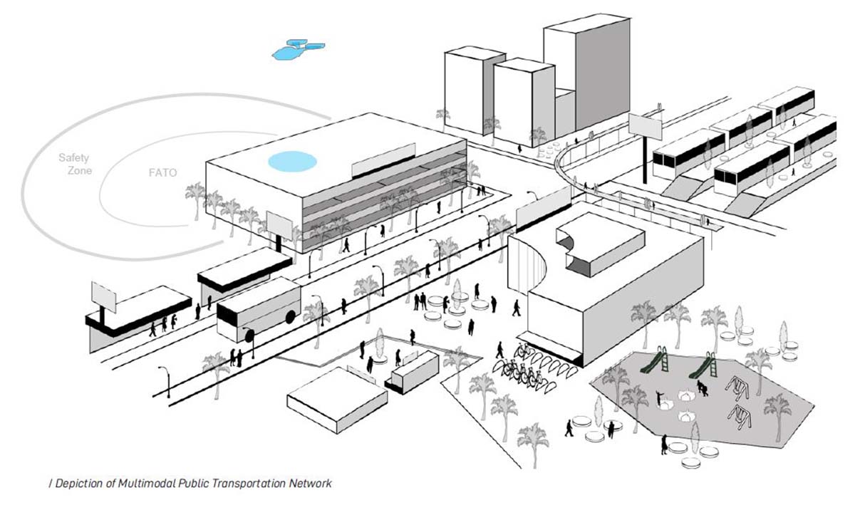

2.3.9
EQUITY AUDIT FOR
COMMUNITY ENGAGEMENT
When deciding where to place vertiports as well as the overall vertiport network and flight paths, achieving equity for under-represented communities must be part of all the considerations.
Equity is both a process and an outcome and should be considered in development of a UAM land use policy as well as for each subsequent vertiport project. The first step is to establish a baseline -define and identify the Angeleno quality of life standards and minimum expectations.
In California, there are several tools that can be leveraged to understand baseline conditions, including the Cal EnviroScreen
(https://oehha.ca.gov/calenviroscreen) and the Healthy Places Index (https://healthyplacesindex.org/).
Additionally, look for options for public benefits such as priority/expedited emergency services benefits, digital policy opportunities, job creation, job training opportunities, etc.
Areas of opportunity to consider for expanding public benefits may include exploring::
- Does a vertiport project disproportionately burden one demographic group over another?
- Is childcare provided for job trainees?
- Are community members being paid to assist with engagement topics?
- Are informative materials translated into multiple languages?
- Can the project help reconcile the legacy of historical inequities?
- Does the location or design of vertiports make it likely that certain demographic groups will have greater access and accrue more of its benefits?
- Are community members being engaged at times and locations that are convenient and culturally specific?
- Does the vertiport project align with and support community priorities?
- Does the vertiport project have accountability to the community to ensure equitable benefit?
- Who has power in this process?
- How can a UAM policy or vertiport project share power with communities?
- What is the history of the location where a vertiport is being considered?
- Are there past injustices that have occurred in that community or to the particular demographic that lives there?
- Has the community identified current or ongoing problems that stem from past injustices?
2.4
UAM Land Use Policy Elements
Zoning Considerations
|
|
Understand current or new zoning considerations / Existing guidelines for heliports (FATO) Evolve UAM flight path boundaries and characteristics (e.g. shorten safety zones) Analysis of emerging navigation technology affects on safety (e.g. autonomous vehicles)
|
|
Safety Regulations
|
|
Consider existing heliport risk levels (Vertiport Protection Zone - VPZ) Data analysis to better determine the risk level present within a VPZ Basedon new technology, further refine the risk levels present within a VPZ
|
|
Compatible Land Uses
|
|
Consider existing acceptable risk and noise levels (Heliports and CEL ) Criteria for geographic location and configuration evaluation ( Including Heliport Influence Area - HIA) Alignment with LADOT’s Strategic Work and City Goals
|
|
Sensitive Land Uses
|
|
Baseline existing sensitive landuses (e.g. schools, protected habitat, land marks, hazardous materials) Align with the City’s vision for preserving the environmental and community benefits Consideration of a Vehicle Classification System (Vehicle type relative to noise levels)
|
|
Noise Contour Areas
|
|
Benchmark Heliport Influence Area (HIA) / LACounty Airport Land Use Plan -( 2004) Noise level evaluation against initial projections (Possible noise monitoring station data comparison) Compare noise effects and influence on land uses (Empirical data from more sophisticated noise models)
|
|
Number of Operations
|
|
Consider background noise levels and acceptability basedon community feedback (Urban, Suburban, Industrial Areas) Corridor capacity integration with public transportation (Align with multimodal network criteria) Density and acceptance analysis (Added corridors and/or access)
|
|
Time of Day Restrictions
|
|
Consider daytime and evening limits (Determine when trip purpose best meet demand; balance with noise considerations) Evaluate effectiveness of any time of day operation limits against community benefit Consideration of a Vehicle Classification System (Vehicle type relative to time of day restrictions)
|
|
First / Last Mile Connections
|
|
Prioritize locations for equitable access and integration with the City’s existing transportation network Further integration with shared active mobility (e.g. bikeshare, scooters) Integration with Mobility Hubs for evolving trip types, higher trip density, and higher pedestrian activity
|
|
Traffic Impacts
|
|
Prioritize the safety of pedestrians (Pick-up / drop-off activity) Evaluation of decreased single occupancy trips (Integration with existing transportation network) Considerations for improving active connections and access (proximity to high capacity transit systems)
|
|
Digital Policy
|
|
Used to implement the City’s tiered regulatory framework potential Complements Land-use policymaking to govern aircraft noise, propulsion type, time of day, day of week operations Served by LADOT’s Digital Policy Platform and integrated with flight planning and airspace management systems Prioritizes deidentified data Useable for updates and compliance monitoring Utilized for flexible and adaptable integration with existing transportation network

3.1 PURPOSE
This chapter outlines possible options for implementing vertiports in the City of Los Angeles.
This early cross departmental collaboration helps all departments align on defining the City’s long-term goal of a future UAM policy as well as ensuring that permitted operators meet the City’s predetermined sustainability, equity, and safety goals.
EXPLORATION OF A REGULATORY PERMITTING PROCESS
In the course of developing policies and site location opportunities for vertiports, the City can consider creating a regulatory permitting process.
This regulatory permitting process can include requirements such as: standards and regulations for passenger movement, standards and regulations for goods movement, existing heliport conversion requirements, operation frequency and schedule information, federal and state safety compliance, fleet information, operational data exchange, flight route information, permit processing fees, insurance and indemnification.
3.2
PERMITTING CONSIDERATIONS FOR VERTIPORT DEVELOPERS
SAFETY
DCP and LADOT are to establish safety guidelines for vertiports to reduce risks to passengers and staff. The City’s responsibility to mitigate safety concerns will consider noise nuisance for the surrounding community and will likely extend to the permitting of vertiport developers and UAM operators.
Best Practices may include, but are not limited to:
- Working with the FAA and other Federal Regulators to ensure alignment on vehicle and operational safety.
- Air operations area (flight deck) are to be for authorized personnel only (trained vertiport staff) with passengers escorted to/from UAM aircraft on the flight deck.
- Building is constructed to helipad / heliport standards (or new vertiport standards) concerning occupancy separations, fire suppression, fall protection, etc.
- Security checkpoints to screen for weapons, prevent hijacking, or other malfeasance.
- In UAM aircraft and at vertiports, provide cameras, voice communications, and “panic button” for operator notification of unsafe conditions or unruly passengers.
- Sound monitoring for analysis of compliance with agreed noise levels for a specific location or type of vertiport.
SAFETY AT THE VERTIPORT
To ensure structural and emergency safety of the vertiport building, the building shall follow the State Heliport (CalTrans Division of Aeronautics) and local building permitting processes (Los Angeles Department of Building and Safety, and Los Angeles Fire Department). It is unlawful to operate a heliport in the State of California without a State Heliport Permit. In the future, a vertiport will most likely fall under a similar or the same category of heliport permitting.
SAFETY FOR PASSENGER AND STAFF
Safety at vertiports will be required to protect passengers, staff, aircraft, and vertiport property from accidental or malicious harm, crime, terrorism, and other threats. Unlawful interference could be acts of terrorism, sabotage, threat to life and property, or communication of a false threat, bombing, etc. Depending on the operations of the vertiport, these security measures may include, but not limited to:
- Security screening intended to deter and prevent hijackings and the transport of explosive, incendiary, or unauthorized weapons aboard UAM aircraft. Staff background checks may be conducted through DOJ or other if determined necessary or beneficial.
- Cybersecurity is intended to protect the information of UAM operators’ business and passengers as well as prevent potential aircraft sabotage. Such an approach should include multi-layered protection, combined with restrictive user policies and constant security monitoring.
DESIGN CONSIDERATIONS MAY INCLUDE, BUT ARE NOT LIMITED TO:
- Size: Touchdown and Lift Off (TLOF) area shall be sized to accommodate the TLOF requirements of the aircraft.
- Weight Capacity: In a circle in the middle of the TLOF, identify the maximum weight of the UAM, in units of thousands of pounds. This number should align with any Vehicle Classification Systems (VCS).
- Charging or refueling of electric powered UAM aircraft.
- Markings: Define the limits of the Touchdown and Lift-off area with a solid red line.
- Safety Net: If the TLOF is elevated above the adjacent roof surface, it shall be outfitted with fall protection. (Load capabilities based on the State Heliport permitting process)
- Fire Protection: Fire Hose Cabinets shall be provided with specified residual pressure and gallons per minute flow as provided by the fire department.
- Lighting: Shield any ambient lighting to avoid affecting the pilot’s vision with unwanted glare.
- Wind Cone: Locate a lighted wind cone assembly that complies with the requirements of FAA Advisory Circular 150/5345-27 (within the line of sight from the vertiport but outside the safety area and below the flight paths)
- Means of Egress: Each vertiport shall have not less than two exits from the TLOF in accordance with the latest California Building Code.
- Separation of Exits: Such egress points shall be separated a minimum of 75 ft. along the perimeter of the TLOF.
- Drainage: Provisions shall be made to drain flammable liquid spillage away from any exit or stairway serving the landing area. (outside certain circumstances to be defined)
- Pavement: Type and strength of pavement material for the TFOL area to handle a long lifecycle and should have a non-slippery surface for people
3.3
PERMITTING CONSIDERATIONS FOR UAM OPERATORS
The UAM ecosystem may benefit from a flexible framework that allows the City to manage market entry and aircraft supply through the permitting of companies, vehicles, and pilots, including certain basic requirements such as a minimum number of aircraft in a permitted fleet.
The City, by way of the Department of City Planning, and in conjunction with the LADOT can consider limitations on number of operators and frequency of flights if the market reaches a saturation of congestion.
Similar to LADOT’s regulations for Taxi and For-Hire vehicles, any new ordinance governing Part 135 air carriers for UAM may consider specifying that all aircraft in service must be part of a managed fleet and will be required to have a FAA approved hazardous materials (dangerous goods) certificate.
Best practices include requirements for UAM operator companies to perform inspections as well as provide pilots with training on aircraft safety and maintenance/inspection checks.
It is possible that certain type of vertiport permitting such as emergency, air ambulances, search and rescue, or other types of first responders may have differing evaluation than other types of UAM operations.
Additionally, the UAM operator companies must maintain records of all inspections, preventative maintenance, and maintenance repair records for each aircraft, and provide detailed descriptions of aircraft maintenance and inspection in their annual business / management plans that are submitted to LADOT.
The City will maintain it's ideals of sustainability, equity, and connectivity as this new mode of transportation becomes introduced to the Los Angeles landscape.
As such, these values will be reflected in policy considerations and the regulatory permitting requirements that the City will set for these new type of urban aircrafts.
3.3.1
FLIGHT PATHS
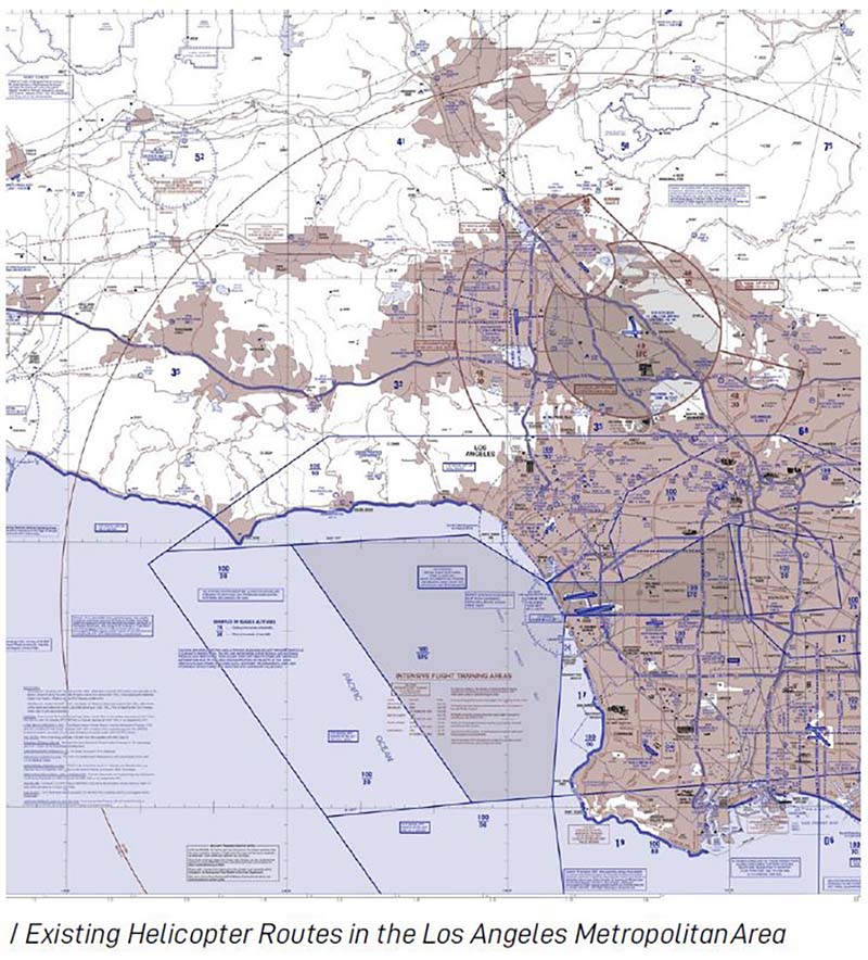
It is expected that the earliest UAM operations traversing between two vertiports will fly along defined helicopter routes. The FAA has published helicopter route charts for eight metropolitan areas in the United States, including Los Angeles.
These helicopter routes tend to overlay highways, freeways, arterial roads, and railways on the ground as a visual reference for pilots while in the air. As the system continues to evolve, these helicopter routes for UAM operations will need to also evolve as they become more complex due to advancement and higher demands of future UAM operations.
To ensure continuous, safe UAM flights, it is within the City’s interest to assist new UAM operators and service providers by delivering and requiring defined systems operating standards. Such systems operating standards should include, but be not limited to, considerations for:
- Equitable distribution of air traffic between vertiports, especially when operating in areas where communities of concern a represent.
- Flight path restrictions and/or mitigation measures that ensure a continuous, efficient, and safe environment for UAM aircraft in intended areas of operations (e.g. avoiding determined incompatible land uses and obstacles affecting navigable airspace).
- Required data and information exchange between UAM operators, PSUs, and city agencies.
- Measurement considerations for noise abatement in areas where higher-tempo and higher density of future UAM operations will occur, especially when operating in areas where communities of concern are present.
- Establishment of a tiered noise violation process where the UAM operator of any aircraft operating contrary to the provisions of a created noise ordinance shall be given a written notice that a violation has occurred. Further violation notices are likely to include fines and eventual UAM operating license termination.
3.3.2
AIRCRAFT OPERATING /
PERFORMANCE STANDARDS
Airworthiness safety and risk management are critical to the integration of UAM into the U.S. National Airspace System (NAS). The aviation safety process, which is well established, includes the design and operation of UAM per FAA rules and regulations. Safety is based on acceptable risks and appropriate mitigations as they pertain to people and property damage. Aircraft must be operated within the environmental and performance parameters defined by the manufacturer and must be maintained in accordance with established instructions for continued airworthiness.
The requirements for aircraft/airworthiness certifications demonstrate that the aircraft design complies with FAA regulations. This would be an expansion of FAR Part 107 in which the FAA will issue waivers/authorizations to certain requirements of Part 107 if an applicant demonstrates they can fly safely under the waiver without endangering people or property on the ground or in the air.
3.3.4
EMISSIONS STANDARDS
Section 233 of the Clean Air Act (CAA)states: No State or political subdivision thereof may adopt or attempt to enforce any standard respect-ing emissions of any air pollutant from any aircraft or engine thereof unless such standard is identical to a standard applicable to such aircraft under this part.
Therefore, LADOT does not have jurisdiction to directly regulate the emissions of UAM aircraft. However, there are several strategies that LADOT and its partners can use to effectively regulate the level of emissions that the public is exposed to from UAM aircraft. Such strategies include but are not limited to:
- Limiting fleet size according to fuel type: all fossil-fuel, hybrid, and all-electric.
- Regulating the types of vehicles that canland on city-permitted vertiports.
- Limiting the provision of fossil-fuel refueling capabilities at city-permitted vertiports (through fire code or other ordinance limiting the presence of fossil fuel storage on-site).
- Providing incentives for eVTOL charging capabilities at city-permitted vertiports.
The California Clean Miles Standard and Incentive Program is a program stipulating that by 2021 there should be an established baseline for GHG emissions by TNCs.
In 2021 annual reduction targets should be defined, and in 2022 each TNC company needs to develop reduction plans to meet a specified target level of greenhouse gases emissions. This process of setting targets is to be repeated every 2years.The City can lobby the State Legislature to extend this to UAM aircraft fleets or work with the legislature to determine if the law can be applied to UAM operators in the future.
Outside of that, DCP and LADOT can determine the best strategy to effectively manage emissions exposure from UAM as the market matures.
3.4
PERMITTING CONSIDERATIONS FOR UAM SERVICE BOOKING AGENCIES
It is important that UAM service booking agencies follow a set of digital guidelines set forth by DCP and LADOT. This is likely whether they will be integrated with UAM operators, vertiport developers, or are independent.
The section on the following pages describes in detail the data guidelines that UAM service booking agencies most likely will need to abide by.

3.4.1
DATA COLLECTION, DATA REPORTING, AND DATA PRIVACY
To satisfy the LADOT Mobility Data Sharing (MDS) Requirements, UAM service booking agencies seeking to operate within the Los Angeles jurisdiction must comply with the Open Mobility Foundation MDS.
GUIDING PRINCIPLES
- Open-Source: allows any city or company to run MDS and related products as a service within their city free from any royalties or license fees.
- Competition: fosters a competitive market for companies to develop products as a service in cities by creating a single platform where everyone is invited to participate and build.
- Data and Privacy: adheres to best practices for privacy standards, commits to data collection transparency, and above all else, protects citizen privacy.
- Harmony: encourages consistent regulation so that providers can offer low cost, predictable services across municipal borders.
- Sustainability: prepares cities for regulating transportation services that are low-emission, resilient, and ultimately better for the environment.
DATA COLLECTION
Required data collection will be consistent with many other Mobility-as-a-Service (MaaS) programs in the United States, including Uber, Lyft, Bird, Lime, and Ford GoBike. Data requirements will be listed in the permit regulations. Required data may likely include:
- Data in the MDS which includes deidentified information on trips, rides, number of vehicles, as well as other system usage statistics to be used in planning efforts;
- A new data feed specification system, similar to General Bikeshare Feed Specification (GBFS) or General Transit Feed Specification (GTFS), which will allow system availability and status information to be shared with the public and third-party operators; and
- Deidentified reporting on system use, memberships, low-income programs, and other pertinent data.
DATA REPORTING
Data reporting will be required for all Operators as it will assist the City in observing changing trends in the industry and inform decisions made by the affected government agencies and by City Council. To operate UAM aircraft within the Los Angeles jurisdiction, Operators will abide by the following data reporting regulations:
Operators shall make deidentified real-time data in MDS format available to the City, and/or a City-designated, third party transportation data analysis platform, for purposes of aggregating this data, evaluating vehicle usage, or enforcing the requirements in a permit. The precise origin and destination points will be obscured to a one-block (or equivalent) radius to protect user privacy. Vehicle IDs must be unique vehicle identifiers that are consistent over time. Operator data may be publicly reported in an aggregated form(s).
Any MDS compatible application programming interface (API) must expose data where:
- The trip starts in or out of the City of Los Angeles,
- The trip ends in the City of Los Angeles or not,
- GPS telemetry data shows the trip passing through the City of Los Angeles.
- Operators shall make deidentified real-time data available via a public API endpoint in the data standard similar to General Bikeshare Feed Specification (GBFS) or General Transit Feed Specification (GTFS), with reasonable modifications to this specification to account for the unique nature of Operator’s UAM aircraft. A smartphone-based application used to hail a UAM aircraft does not qualify as a publicly accessible application program interface. Public UAM feeds may omit aircraft IDs to protect user privacy.
- The public API need not be available without authentication; however, any member of the public, including commercial entities, can gain access to the data provided by the API by requesting access through a web interface. Moreover, the provider should provide access on an average of at least 50 requests an hour.
More information about MDS can be found online at
https://github.com/openmobilityfoundation/mobility-data-specification.
LADOT reserves the right to share data collected with third parties to process and analyze data and to use it for program planning and operations purposes.
DATA REPORTING
- Operators must provide reports on key performance indicators, including, but not limited to, the following:
- Utilization rates;
- Total downloads, active users, and repeat user information;
- Total trips by day of week and time of day;
- Origins and destinations;
- Trips per UAM aircraft by day of the week, time of day;
- Average trip distance;
- UAM aircraft maintenance reports (including but not limited to UAM aircraft identification number and maintenance performed);
- Incidents of theft and vandalism;
- Number of complaints;
- Number of crashes or collisions, including the date and time of the incident, UAM aircraft ID, location of the incident (geo coordinates), traveling path of the aircraft, the severity of the incident (fatality, injury, or property damage only), and if Police report was filed;
- Payment method information;
- Rebalancing to designated service areas;
- Number of customers participating in the low-income discount program; and
- Number of discounted rides taken.
- Operators must provide reports on a quarterly basis.
- Operators must agree to distribute an opt-in user survey, developed by LADOT or a designated third party, to all Users annually and to provide input on survey questions.
- The Operator agrees not to engage in anti-competitive behavior with other UAM aircraft Operators, including falsifying data.
- Operators shall provide real-time access to data showing the location of all their UAM aircraft.
DATA PRIVACY
Data collection poses risks to personal privacy and threats to innovation and competition. Therefore, data should be collected in a quantity and at a level of detail that is reasonably necessary to implement and ensure compliance with new regulations or to deliver legitimate public policy outcomes. Personal privacy rights of passengers and pilots and should be protected and not result in the disclosure of confidential business information.
The rules and regulations should require trip data to be deidentified and specify that it will be used only for the stewardship of the public right of way including areas involving public safety, congestion management, and transportation planning, including curbside management, traffic management, multimodal service planning, and the allocation of public funding for those purposes.
Operators will be responsible for protecting any personally identifiable information from unauthorized use by implementing the following standards:
- The Operator must employ an electronic payment system that is compliant with the Payment Card Industry Data Security Standards (PCI DSS), and provide proof of compliance.
- The Operator must provide a Privacy Policy that .safeguards Customers’ personal, financial, travel information, and usage
- The Operator should clearly communicate to the public and the City what personal information is being collected about Users, how it is being used, and for how long.
- The Operator should produce a Privacy Policy that complies with the California Online Privacy Protection Act (CalOPPA) and any data protection laws applicable to minors, and further, expressly limits the collection, storage, or usage of any personally identifiable information to the extent required to accomplish the provision of the Urban Air Mobility system.
3.5
COORDINATION / CONSIDERATIONS FOR CARGO UAS
Like UAM, Unpiloted aircraft system (UAS) cargo delivery is a subset of the NASA’s and FAA’s Advanced Air Mobility (AAM), an industry initiative to develop an air transportation system that moves people and cargo between local, regional, intraregional, and urban places previously not served or underserved by aviation using revolutionary new aircraft. The commercial applications and opportunities for UAS operations, particularly at low altitudes, across a myriad of sectors from inspection, to survey, to monitoring, to package delivery, present enormously enticing incentives and business cases. While all of these applications for UAS operations are useful for Los Angeles, the largest interest to the City would likely be cargo UAS delivery.
Cargo delivery drones may be much smaller than person-carrying UAM aircraft, therefore they may have different landing sites, different designated airspace, and different air traffic management rules, as developed in parallel with UAM, in a system designated by NASA and FAA as UAS Traffic Management or “UTM”, with UTM operations managed by UAS Service Suppliers (USS).
UTM has been under development for several years, with an FAA ConOps V2.0 that is a few years ahead of the recently issued UAM ConOps.
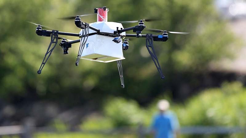
SOCIALIZATION AND COMMUNITY ENGAGEMENT
The Major’s Office recently announced a new partnership to introduce Urban Air Mobility, becoming one of the first US cities to provide government support to this emerging industry. The Urban Air Mobility Partnership is a public-private collaboration between the Mayor’s office, the Los Angeles Department of Transportation, and Urban Movement Labs, a public entity created to test new mobility ideas. Private sector participants include Designworks, Arup, Ellis and Associates, and is financially sponsored by the UAM Division of Hyundai Motor Group. This one year project will map out challenges to UAM in the city, implement solutions to challenges, visualize a vertiport, hire a UAM fellow to advance public engagement around UAM, and create a policy toolkit for UAM that may be adopted by local governments across the United States.
INTERAGENCY POLICY
DEVELOPMENT COORDINATION
The City should identify key stakeholders to be involved from each city agency and a committee lead to take on development of a UAM policy. Policy should articulate the City’s desired role relative to Federal agencies and regional partner governments. In addition to operational stakeholders and interagency coordination, community engagement should be the primary focal point.
An advisory committee should be created to involve local communities for meaningful policy development, including equity policies related to cost of service, geographic distribution of vertiports, geographic distribution of UAS drops, frequency and density of service to underserved areas,etc.
EQUITY
Equity and inclusion shall remain key priorities for UAM long term success in Los Angeles. UAM Policy considerations, supported by a dynamic Digital Policy, can be used to ensure equitable access to take off and landing sites and to increase community benefits overall from UAM in Los Angeles.
FUTURE UAM SERVICE PLANNING
City agencies should consider a land use and permitting policy for vertiports that includes an approach to California Environmental Quality Act Guidelines (CEQA) compliance. This may entail a decision on site-by-site or system-wide CEQA clearance. The City, State, and Federal agencies shall continue collaborative dialogue around defining governance over vertiport deployment.
JOB CREATION
The City can begin evaluating the type and number of jobs Operators will require to support UAM services. Investigation into these jobs can inform the type of training necessary for new employment opportunities created through UAM.
DIGITAL POLICY
Deidentified data collected through the MDS can be used to continually improve UAM operations and to support a flexible approach to an evolving technological landscape. Voluntary options to use personal data may help evaluate new or enhanced services or assist the City improve rider experience.
INTERMODAL CONNECTIVITY
The City can begin to include UAM services as consideration in new or on-going research and development projects. Consideration of UAM services in projects today can help define the criteria that will be necessary for successful integration of UAM into Los Angeles’ transportation network.
SUSTAINABILITY
The City can incentivize UAM operators and reward riders for choosing UAM vehicles that help decarbonize the City’s transportation network. The infrastructure needed to support UAM would ideally be the same as other forms of shared mobility to ease adoption of zero emission modes of travel and reduce single occupancy trips.
Acknowledgments
Prepared for the Los Angeles Department of Transportation
Seleta J. Reynolds, General Manager
Marcel Porras, Chief Sustainability Officer
Janna Smith, Supervising Transportation Planner
Consultants
Designworks
Peter Falt – Project Lead
Margaux Reynolds
Jonathan Markowski
Amanda Wu
Yangdi Xue
Natalie Linden
Ellis and Associates
Todd Petersen
Arup
Elizabeth Valmont
Ryan Biziorek
Byron Thurber
Paul Moore
Nina Harvey
Jon Swan
Bettine Gommer
Justin Guan
Support provided by:
Gabriela Juárez, AICP, Los Angeles Department of City Planning
Conni Pallini, Los Angeles Department of City Planning
Ken Bernstein, Los Angeles Department of City Planning
Julia Thayne DeMordaunt, Office of Los Angeles Mayor Eric Garcetti
Karina Macias, Office of Los Angeles Mayor Eric Garcetti
Clint Harper, Office of Los Angeles Mayor Eric Garcetti

